
As summer-like heat continues across the Houston metro area, an emerging pattern in the eastern Pacific Ocean could make traditional winter weather harder to come by and worsen the Texas drought.
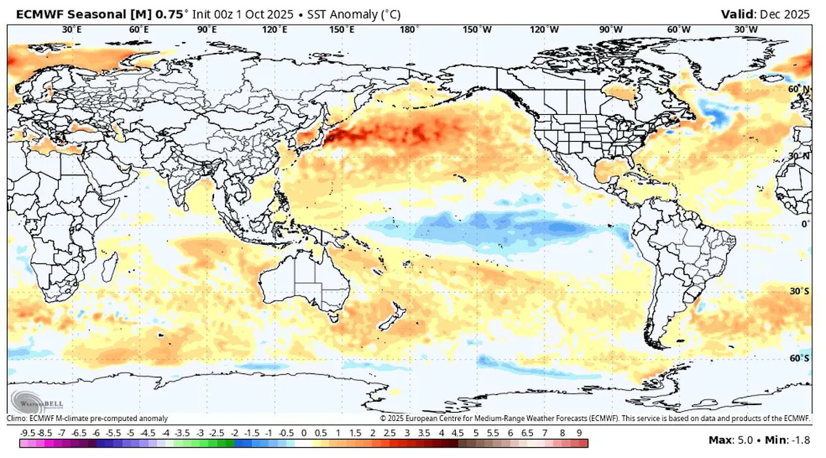
La Niña, when equatorial waters in the eastern Pacific turn cooler than normal, has returned and it could shape the region’s weather well into next year. The National Weather Service’s Climate Prediction Center confirmed in late September that La Niña is now in place and is expected to persist through February 2026 before sea-surface temperatures ease back toward average levels in early spring.
{ “__type”: “devHubFreeformEmbed”, “__id”: “Datawrapper”, “__fallbackImage”: “https://datawrapper.dwcdn.net/aR3vg/mobile.png”, “__data”: { “datawrapper_id”: “aR3vg” } }
La Niña forms when trade winds strengthen across the equatorial Pacific, pushing warm water west toward Asia and allowing cooler, nutrient-rich waters to surface off South America. Those subtle shifts can ripple across global weather systems and for Texas, the result is often a familiar one: fewer storms, less rainfall, and warmer days through the fall and winter months.
HURRICANE SEASON: While Texas’s hurricane season may be over, La Niña can influence how active the Atlantic hurricane season can be.
“This is the most important oceanic temperature pattern for our wintertime weather,” said John Nielsen-Gammon, Texas state climatologist and director of the Southern Regional Climate Center. “It’s been relatively dry over the past couple of months, so a continuation of dry weather could allow more widespread drought to develop.”
La Niña could mean dry Texas winter
More than 70% of Texas is dealing with abnormally dry conditions, according to data this week from the U.S. Drought Monitor. October rainfall has barely registered at Houston’s official climate observation site, Bush Intercontinental Airport, and parts of Harris County have slipped into moderate drought.
The Climate Prediction Center and the North American Multi-Model Ensemble both point to a weak La Niña, meaning the Pacific cooling is modest but persistent. Even so, the setup tends to deflect storm systems northward, leaving the southern United States on the dry, sunny side of the jet stream. That keeps high atmospheric pressure locked in place, sustaining the same kind of heat and drought pattern Texans have already endured through much of 2025.
If that trend continues, Houston’s dry streak could stretch deep into winter, with rainfall totals lagging far behind normal.
Drought and wildfire risk during La Niña
Dry weather doesn’t just mean brown lawns. Soil moisture is dropping across Texas as reservoirs decline and wildfire fuel loads increase.
“The La Niña poster child would be the winter of 2010 to 2011,” Nielsen-Gammon said. “That winter was the start of the driest water year in Texas history and had the most active wildfires in recent memory.”
TEXAS DROUGHT: As drought worsens across Southeast Texas, history shows how bad a dry fall season can get.
That 2011 season saw more than 31,000 wildfires burn millions of acres statewide, according to Texas A&M Forest Service data. While this year’s La Niña is expected to remain weak, Nielsen-Gammon notes that even small departures from average can intensify existing drought, particularly in southeast Texas, where October has already been unusually hot and rain-starved.
La Niña and cold snaps
Despite La Niña’s reputation for warmer winters, Texas cold fronts remain a threat.
“The highest risk of extreme cold outbreaks in Texas seems to be during mild La Niña winters,” Nielsen-Gammon said, pointing to the state’s recent history.
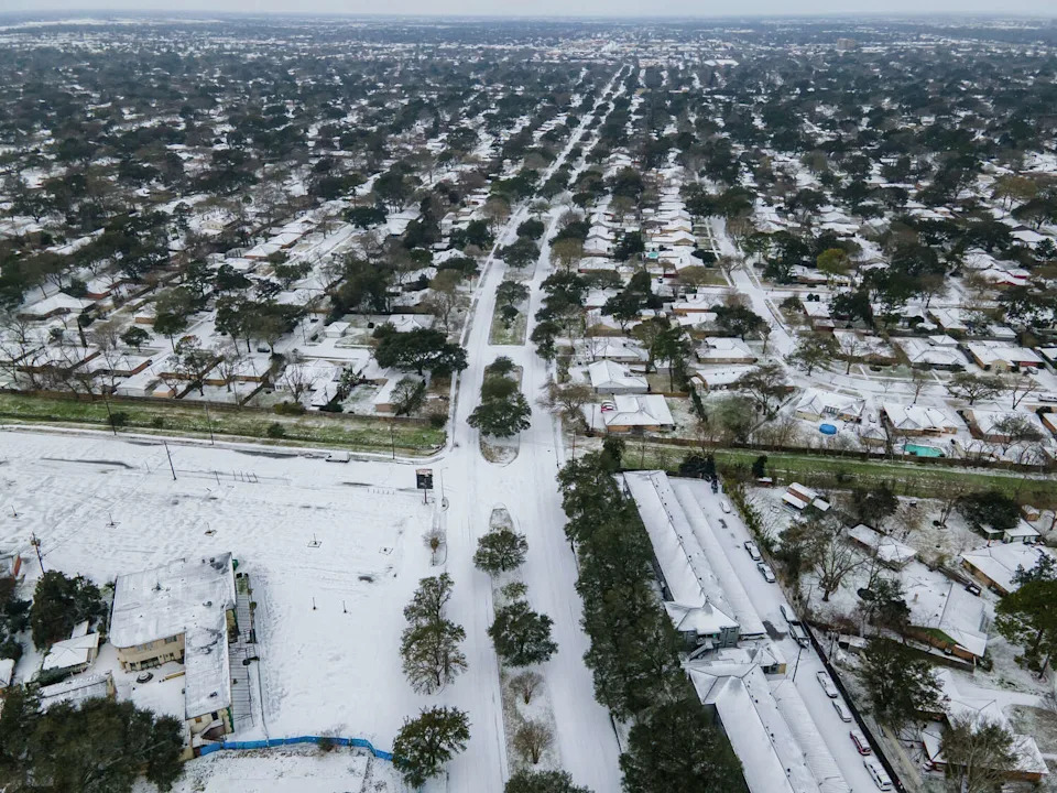
Snow covers West Belfort Street in Houston’s Westbury neighborhood on Feb. 15, 2021. The historic February 2021 freeze in Texas brought heavy snowfall during a La Niña winter. (Mark Mulligan/Staff photographer)
During the 2020-21 La Niña winter, Houston ran slightly warmer than average in January – until the February freeze plunged temperatures into the teens, crippling power systems and causing billions in damage. That season remains a reminder that La Niña can still deliver surprises, even in an overall warm setup.
What can Texas expect this winter?
The Climate Prediction Center’s seasonal outlook shows above-average temperatures and below-normal rainfall likely through the end of 2025. Unless a major pattern shift develops, Southeast Texas may not see meaningful relief until early spring, when La Niña is forecast to fade.
That means drought and wildfire risks could persist through the holidays, especially in areas already under burn bans. Of Texas’s 254 counties, 151 are under burn bans.
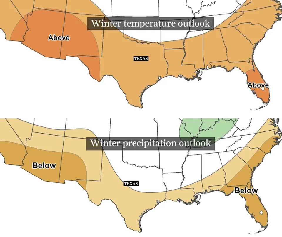
These maps from the National Weather Service’s Climate Prediction Center shows the temperature and precipitation outlook between December 2025 and February 2026. Above-normal temperatures are expected across Texas, top, while below-normal precipitation is expected. (Climate Prediction Center)
“If you’re hoping for a cold, wet winter,” said Nielsen-Gammon, “La Niña probably isn’t your friend.”
But La Niña’s reach extends far beyond Texas. The Pacific pattern can suppress rainfall across the southern United States, enhance storm activity during the Atlantic hurricane season, and redirect the jet stream over North America and Asia. Combined with record ocean warmth and an already warming climate, even a weak La Niña could amplify extremes – deepening drought in the south while fueling wetter, stormier weather elsewhere.
For now, Houston’s skies tell the story: more sun than rain, more warmth than chill, and another winter that may feel like summer never really left.
This article originally published at La Niña could bring another warm, dry winter to Houston and Texas. Here’s what we know.