
FORECAST HIGHLIGHTS
MORNING FOG & CLOUDS, WARMTH: This will be the trend all week long
VERY SMALL SHOT AT RAIN: Mainly Tuesday, light & brief
TOASTY CHRISTMAS: Likely near 80°, warmer than average across the nation, too
FORECAST
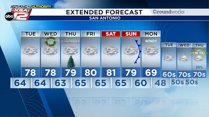
THIS WEEK
Humidity is back. It is rolling in this morning and it’ll camp out over South Texas all week long. This means we’ll be in more of a spring-like pattern of morning clouds (lasting until about noon) and afternoon sunshine. Plus, it’ll be warm. Highs will be in the mid-70s to near 80 through at least Saturday.
VERY SMALL SHOT AT RAIN
A little disturbance in the Gulf will rotate up toward San Antonio on Tuesday. While this could spark off a shower or two, any rain will be brief and light.
Futurecast for Tuesday afternoon (Copyright KSAT-12 2025 – All Rights Reserved)
CHRISTMAS EVE/CHRISTMAS DAY
Expect a high near 80 both days, with lots of humidity. Morning clouds will give way to afternoon sunshine.
About 15° above average for Christmas in San Antonio. (Copyright 2024 by KSAT – All rights reserved.)
CHRISTMAS WARMTH ACROSS THE NATION
It’s not just warm around San Antonio! I’ll be, in some cases, 20° to 25° warmer than average across the nation. Many places will be breaking a record for their warmest Christmases ever!
Christmas Day will be warm across the nation! (Copyright 2025 by KSAT – All rights reserved.)
2025 A RECORD YEAR?
There’s a high likelihood that 2025 in San Antonio will finish as the 2nd warmest year on record. We currently hold an average temperature of 72.9°. Which year holds the record for warmest? 2024. Interestingly, 2023 comes in third. It’s been a hot three years!
If 2025 ended today, it would be the 2nd warmest on record (Copyright KSAT-12 2025 – All Rights Reserved)Daily Forecast
KSAT meteorologists keep you on top of the ever-changing South Texas weather.
QUICK WEATHER LINKS
Copyright 2025 by KSAT – All rights reserved.