
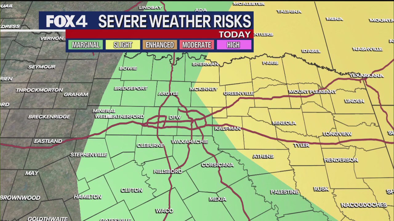
DALLAS – North Texas is bracing for a cold front expected to bring strong to severe thunderstorms, primarily impacting areas east of the Dallas-Fort Worth Metroplex this afternoon and early evening. While computer models initially showed a weaker system, forecasters have increased rain and thunderstorm coverage, noting a “marginal risk” for most of North Texas and a “slight risk” for eastern zones.
Live Radar 
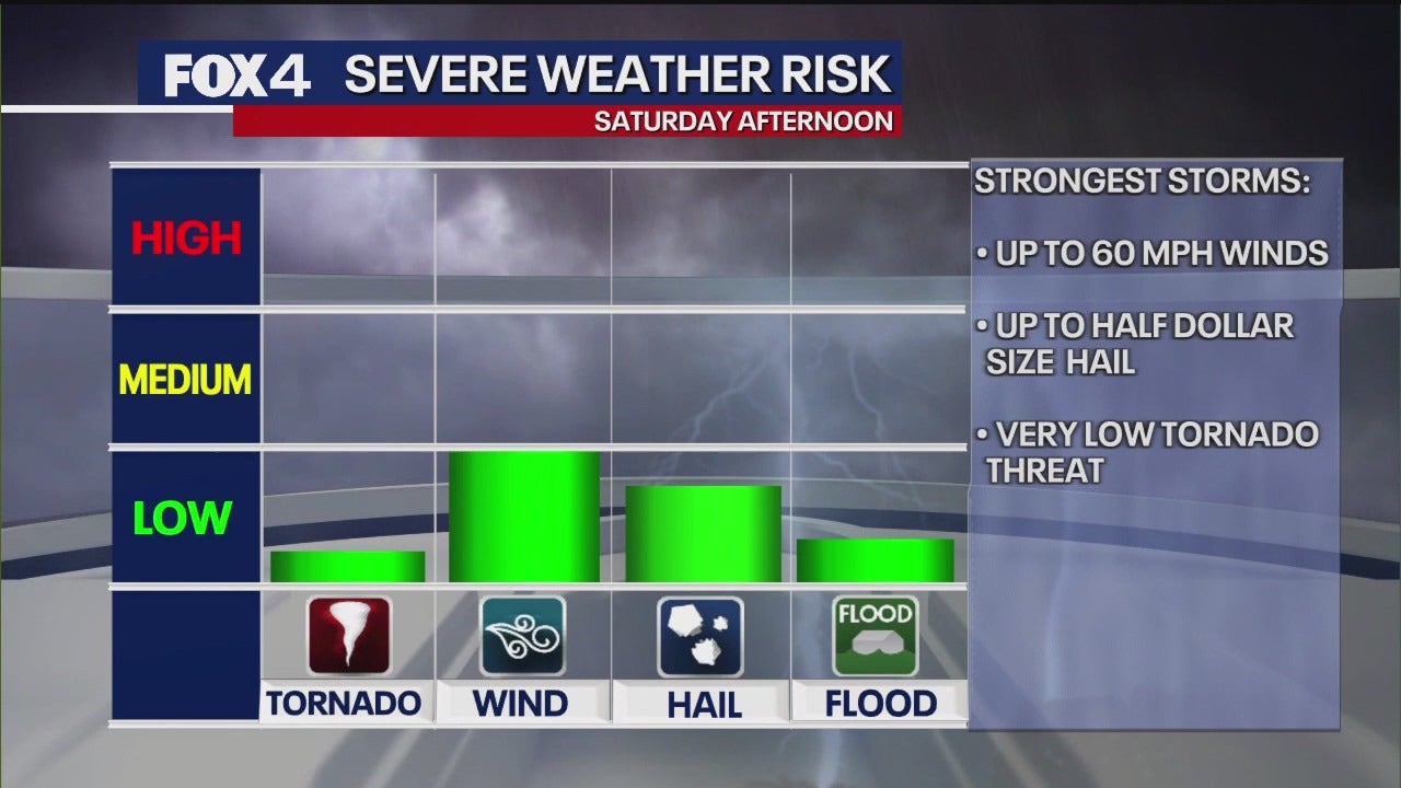
The primary threats from these storms are expected to be damaging winds, potentially gusting up to 60 mph, and hail up to half-dollar size. While a “very low tornado threat” exists, it is confined to the slight risk area. Forecasters emphasize that not all areas will experience severe weather.
It’s been several weeks since we’ve had some rough weather and storms, even across any portion of North Texas, so please have the WAPP and take your time. Wait till everything passes and then the rest of the day should be good for you.
Storms are moving quickly from west to east. Early morning showers have already lifted northeast into Cook and Grayson counties and Oklahoma. The main complex of thunderstorms is expected to intensify as temperatures rise, particularly after 10 a.m.
Weather Today
The big concern throughout this forecast is today, especially between about noon to 6 p.m. That is when the threat for those strong to severe storms will be out there. Please keep your eye to the sky. I know that we’ll be keeping you updated on air and online.
Timeline:
By noon, scattered showers and storms are anticipated across the Metroplex, with more activity to the west. The severe threat is considered greater in the eastern and southeastern zones, where temperatures will be warmest, allowing for more atmospheric heating.
By 2 p.m., the more intense weather is projected to shift into the eastern and southeastern zones. By 4 p.m., most areas from the I-35 corridor westward are expected to be quiet. However, thunderstorms may persist in far eastern and southeastern zones, such as Palestine or Mejia, until 6 or even 7 p.m.
Following the storms, northerly winds will take over, ushering in significantly cooler temperatures.
Sunday Forecast
Tomorrow, the last full day of the fair, is expected to be fantastic, with clear skies and morning lows in the 50s. The high temperature tomorrow is forecast to be 75 degrees, below the average of 78 degrees for the first time in a while.
Monday Forecast
The clear skies and cooler temperatures will continue into Monday morning before a quick warm-up brings temperatures into the upper 80s for one day. More disturbances are expected next week, leading to additional rain chances but also tempering the high temperatures, with upper 80s and low 90s not expected for the most part.
7-Day Forecast 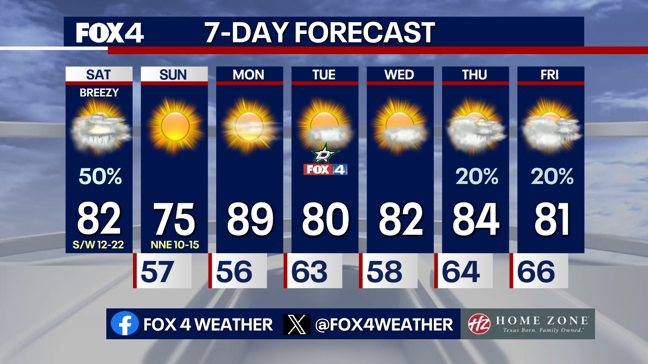
The Source: Information in this article is from the FOX 4 Weather Team.