
HOUSTON – TRACKING Tonight’s Front:
30-Degree Temperature Drop, Scattered Showers, and Wind! Hold on tight to your Christmas decorations — your inflatables might blow away — thanks to a strong front impacting you and your family tonight into tomorrow!
Wind Alerts (Copyright 2025 by KPRC Click2Houston – All rights reserved.)
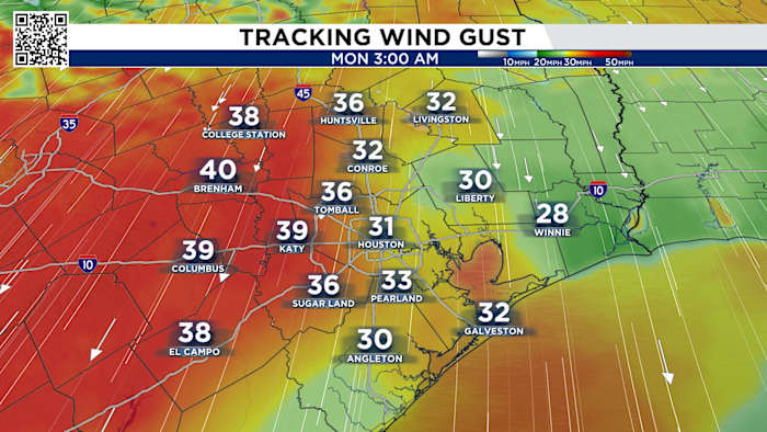
Not only are we tracking a chance for rain and a dramatic temperature drop, but a Wind Advisory for some (not all) has been issued tonight at 9 PM through Monday at 6 PM for Brazos Valley and our coast communities, starting tonight at midnight through Monday at 6 PM. We’re tracking sustained winds of 20–30 mph with wind gust peaks at 40–45 mph.
Tracking wind gusts (Copyright 2025 by KPRC Click2Houston – All rights reserved.)
Today’s High:
Yesterday, we came close to tying a record — the record high for Saturday was 83 in 2016, and we hit 82 at 2:05 PM. Today we could tie the record for heat – 82 in 2021.
Foggy start with an above average temperaturesCold Front Sunday Night:
A front moves through Southeast Texas late Sunday night. It will bring a chance for showers early Monday morning but more importantly, it brings a HUGE temperature drop. Although the timing can change, here is what I’m tracking this morning: Our front pushes through around 10 PM to areas north of I-10 and by 11 PM to areas south of I-10, with the chance for a spotty shower or two from 3–5
Cold Front
Highs fall from the lower-80s this weekend to the 50s as we start next week. It’s about time! But we’ll be back in the 70s by Friday!
Tracking your highs (Copyright 2025 by KPRC Click2Houston – All rights reserved.)
Morning lows drop into the 30s Tuesday and Wednesday, and I wouldn’t be surprised if a few spots see a light freeze, with some feels-like temperatures in the 20s! We’re jumping by 20 degrees in terms of our morning lows from Tuesday to Friday,
Tracking our lows (Copyright 2025 by KPRC Click2Houston – All rights reserved.)Your Extended Forecast:
Our cool down will be pretty short lived. We’re back in the 70s as we start 2026. At least it won’t be in the 80s!
Tracking your 10 day! (Copyright 2025 by KPRC Click2Houston – All rights reserved.)
Stay up to date with the latest changes using Storm Tracker 2 radar and regular updates from the KPRC 2 Weather Team on Click2Houston.
Anthony’s Weather Lab
More Stories Like This In Our Email Newsletter
Copyright 2025 by KPRC Click2Houston – All rights reserved.