
LUBBOCK, Texas (KCBD) – Throughout much of December an area of high pressure remained nearly stationary over the southwestern US. At times, the center shifted toward the South Plains.
In that location, the high forced incoming Pacific systems to the north. These weather systems then moved eastward well to the north of our area. In December and early January, the position of the high was far enough east that the moisture-laden systems made it to the western states before being deflected north. You may remember the reports of the heavy rains and mountain snows last month and at the start of the New Year.
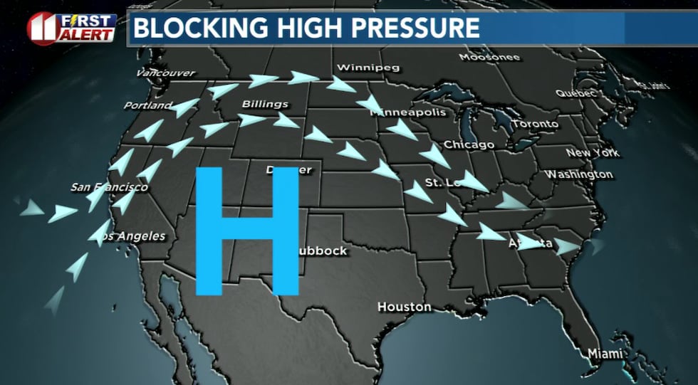 The approximate position which kept us dry and very warm through much of December.(KCBD First Alert)
As the center of the high shifted toward us at times in December, the sinking (and therefore compression) of air contributed to not just well-above average temperatures but much-above average temperatures. Lubbock set several daily high temperature records during that time.
This blocking is returning, but this time the center is farther west, closer to the West Coast.
While both positions effectively block storms from the Pacific – the ones with the most moisture – from making it into West Texas, this time things are a little different. The set up this week has the center of the high near the West Coast. This will deflect incoming systems northward before they have a chance to drop precipitation on the western states. It also, unfortunately, is still near enough to prevent significant moisture from reaching the South Plains.
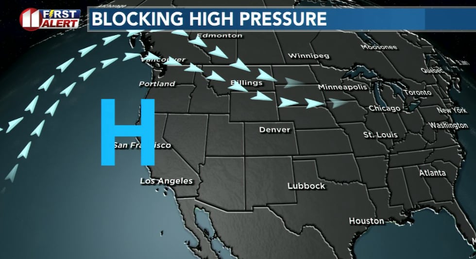 High pressure will keep West Texas dry through at least early next week.(KCBD First Alert)
While our area will be under the influence of this high, keeping us dry, due to the farther west position of its center we won’t have the record highs we saw in December. Close enough, however, to still moderate our temperatures. Though our forecast highs take on the curves of a rollercoaster, the deepest dips drop us only to around the average for the time of year.
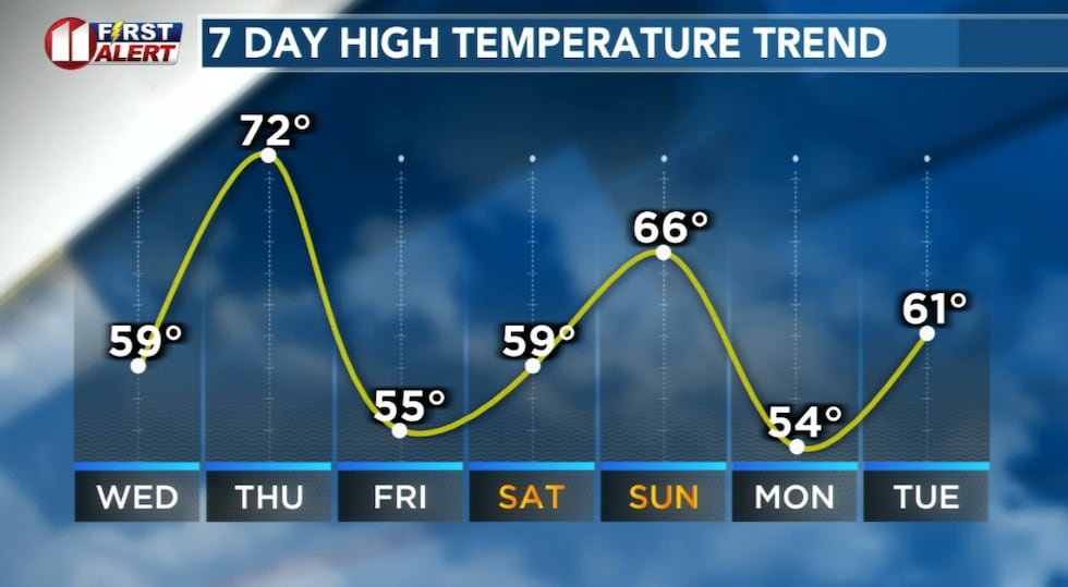 A rollercoaster ride, but even the deepest dips are still near average highs.(KCBD First Alert)
The temperature dips follow cold fronts. The first of which will arrive before sunrise tomorrow, Wednesday. The temperature drops, the wind blow, but no precipitation falls.
A quick warm up to well-above average high temperatures will follow Thursday.
The second front arrives early Friday. Again, the temperature drops, the wind blows, but no precipitation falls.
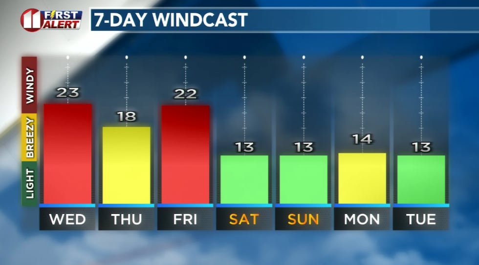 Gusty winds follow cold fronts early Wednesday and early Friday.(KCBD First Alert)
All of which will be followed by a dry weekend.
The high pressure area is expected to continue to linger off or near the West Coast into early next week. Perhaps until the middle of next week.
OF NOTE
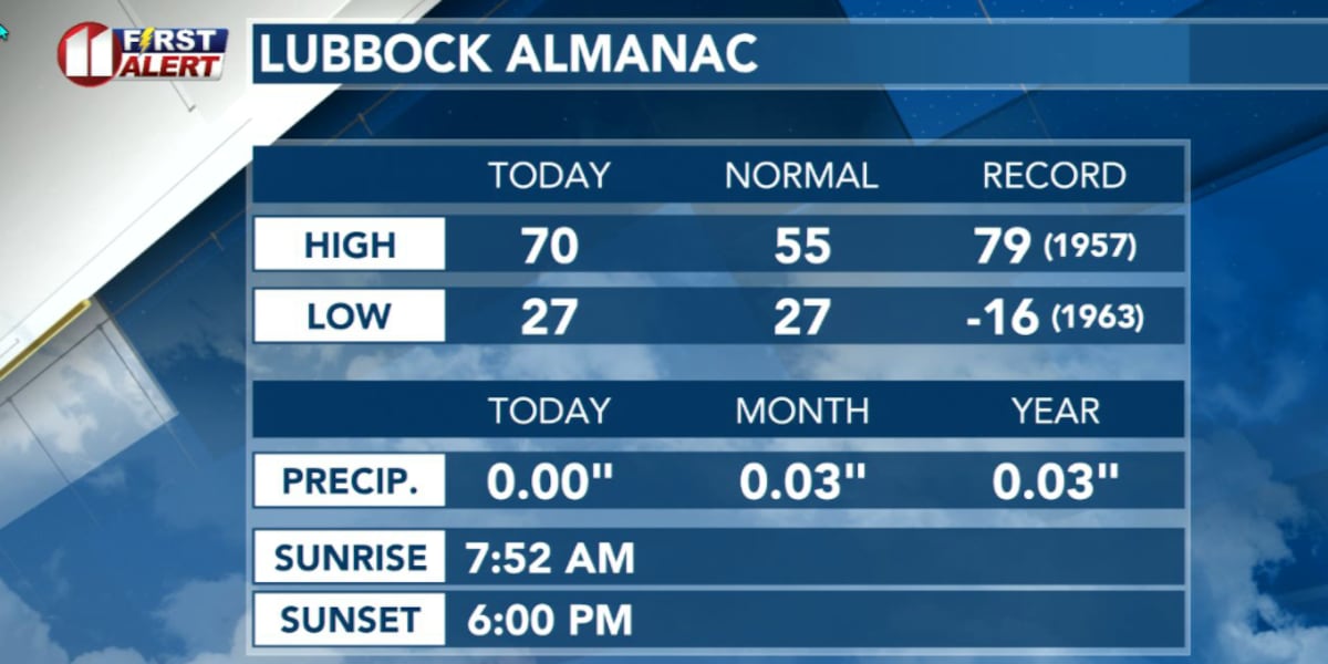
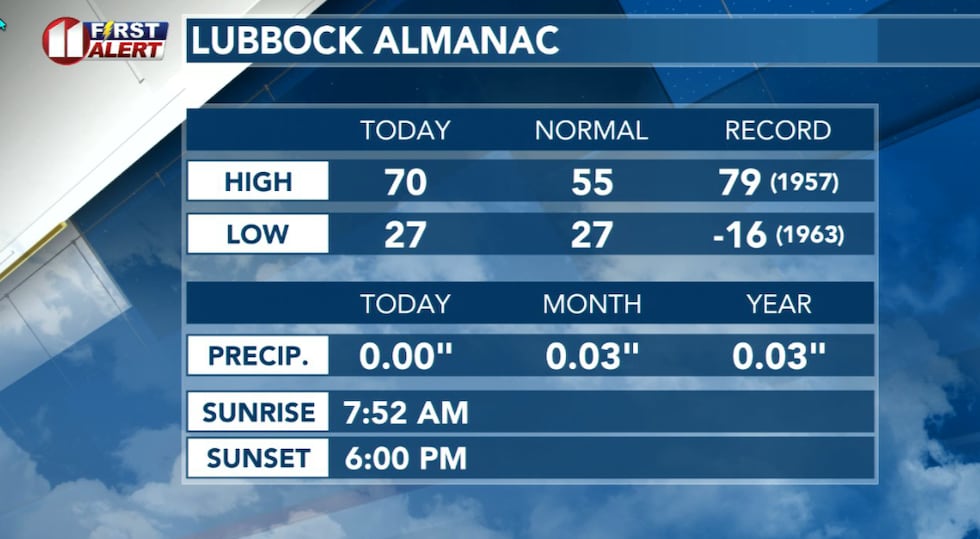
At this time of year, Lubbock’s average low is 27°. Take note, on this date in 1963, the temperature dropped to 16 degrees BELOW ZERO. It’s the second coldest temperature in Lubbock’s record, which dates from 1911. The coldest was 17 BELOW ZERO on February 8, 1933!
 Lubbock Almanac for Tuesday, January 13.(KCBD First Alert)
Lubbock’s average high this time of year is 55°. Lubbock’s January 13 record high is 79° in 1957.
Lubbock’s January 14 record high is 82° in 1928. Lubbock’s January 14 record low is 3° in 1963.
OUR FORECAST, 24-7
Keep up with our latest forecast, including our outlook for the Martin Luther King, Jr. holiday, right here on our KCBD Weather Page. It’s available 24-7. After closing this story, scroll down the page to the current weather and forecast section. You can also find the same information in our KCBD Weather app. It, too, is free. Visit your app/play store and search for “kcbd weather”. If you do download the app, or already have, thank you. We appreciate you!
ON THIS DATE
On this date in 1992, a small but vigorous upper-level disturbance brought heavy snow to the South Plains. Bailey County reported the heaviest snowfall with 7 inches measured in Muleshoe. Lubbock measured 5.5 inches of snow with similar totals elsewhere. The snow contributed to a number of minor accidents, but no injuries or significant damage were reported.
(National Weather Service Lubbock)
Copyright 2026 KCBD. All rights reserved.