
Colder Air Builds, With Possible Winter Impacts This Weekend
Texas has spent most of this winter on easy mode. Warm afternoons, limited rain, very few true cold snaps, and long stretches where nothing much happened. That pattern is finally starting to break.
Over the next several days, we’ll see a noticeable shift toward colder and more active weather across the state, with the potential for winter-related impacts by the weekend.
This won’t be an instant flip of the switch today, but the trend is clearly heading in that direction.
Early Week: A Split State and Some Much-Needed Rain
Right now, weather conditions are split across Texas.
West Texas and the Panhandle are already feeling colder air, with a few light snow flurries possible today. These flurries are not expected to accumulate or cause travel issues, but they’re a sign that colder air is already working its way south.
Meanwhile, much of Central, East, and South Texas remains milder and cloudier.
By Tuesday night into Wednesday, attention shifts east as a disturbance moves across the southern United States. This system will bring rain to East Texas, Southeast Texas, and the Piney Woods. Some areas could see up to around a half inch of rain, which would be welcome relief given how dry conditions have been.
This is not a severe weather setup, and flooding is not expected. The biggest benefit will be reduced fire danger and a short-term improvement in soil moisture across eastern parts of the state.
Late Week: A Stronger Cold Front Arrives
After midweek rain exits, the pattern becomes much more serious.
Late Friday, a strong cold front is expected to move south across Texas. Confidence has increased significantly that this front will usher in a true Arctic air mass that settles in for several days, not just a quick overnight chill.
This will likely be the coldest stretch of weather Texas has seen so far this winter.
Temperatures will fall sharply behind the front, and strong north winds will make it feel even colder. In parts of West and North Texas, daytime highs may struggle to climb above freezing for multiple days.
Why This Weekend Matters: Cold Air Meets Moisture
What makes this setup worth watching closely is the timing.
As Arctic air pushes south, a storm system is expected to move in from the southwest. This combination is one of the classic ways Texas ends up with winter weather.
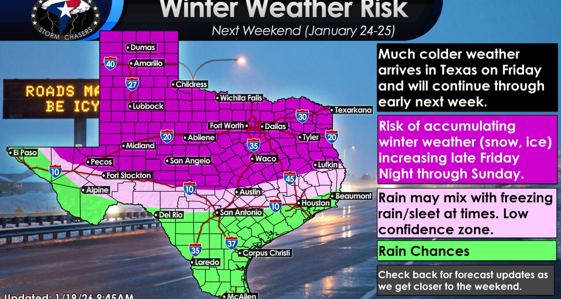
Much colder weather is expected to move into Texas this weekend and continue into early next week, with winter precipitation and travel impacts possible in some areas.
Right now, the highest confidence for winter impacts is across the northern half of Texas. This includes:
The Panhandle
West Texas
The Permian Basin
The Big Country
North Texas and Texoma
Parts of Central Texas
In these areas, snow, sleet, freezing rain, or a mix of winter precipitation is possible beginning late Friday and continuing into Saturday, with impacts potentially lingering into Sunday.
Travel could become difficult, especially if precipitation overlaps with prolonged sub-freezing temperatures.
Farther South: Lower Confidence, Not Zero Risk
Farther south, confidence is lower, but that does not mean risk is zero.
Parts of the Hill Country, Brazos Valley, and South Central Texas could end up near the transition zone between cold rain and winter precipitation. Small changes in temperature or timing could determine whether rain stays liquid or changes over to ice or snow.
These are the kinds of setups where details matter, and those details will continue to evolve over the next few days.
How Cold Are We Talking?
This system has the potential to bring the coldest air of the season so far.
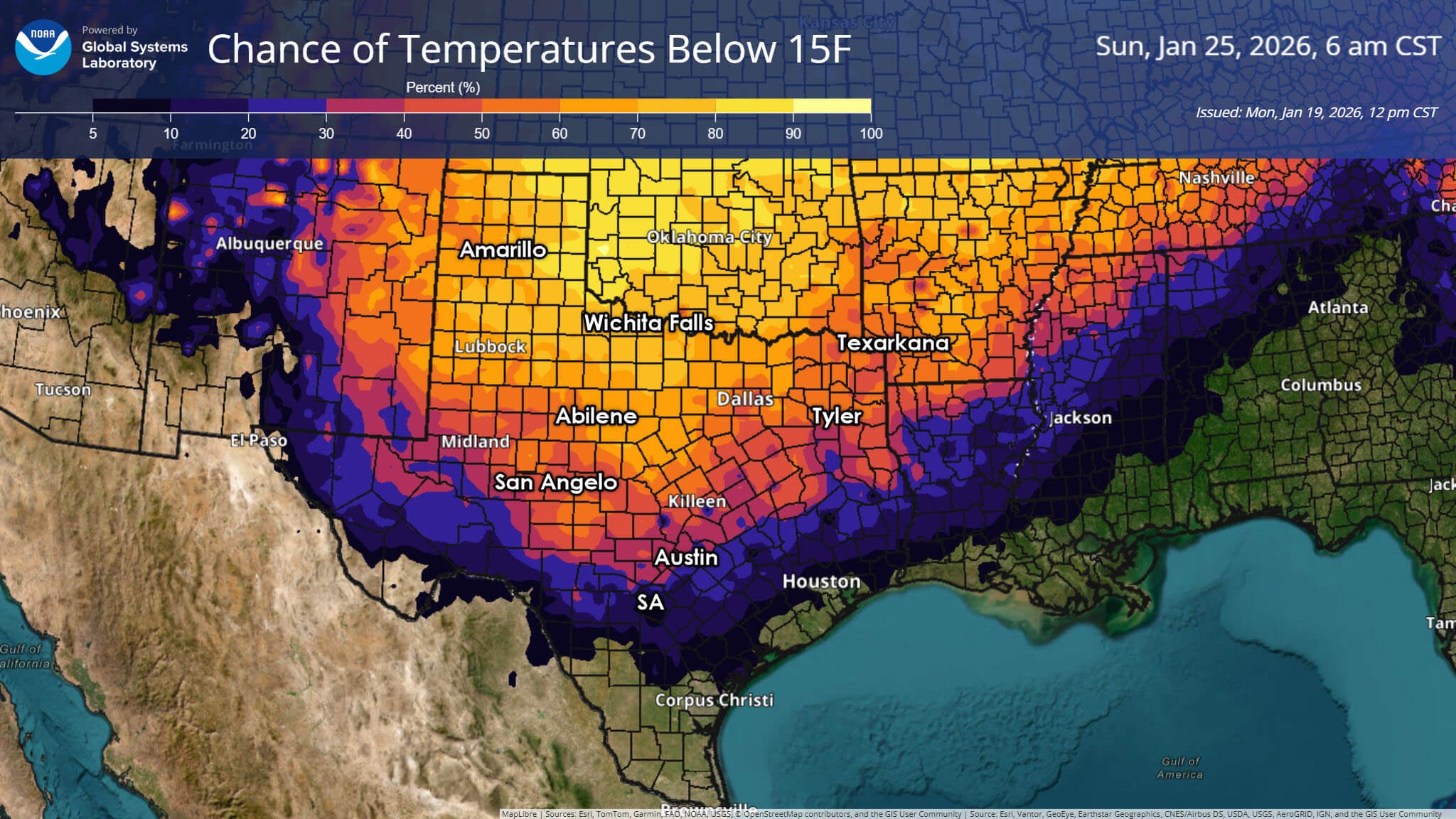
Confidence is increasing that much colder air will spread across Texas this weekend into early next week, with a growing chance of very cold temperatures in parts of the state.
In North and West Texas, overnight lows could fall into the teens or even single digits, with wind chills near or below zero at times. Daytime highs in those areas may remain below freezing for more than one day.
Farther south, freezing temperatures could reach areas that haven’t seen them yet this winter, particularly overnight. Even places that avoid winter precipitation may still need to prepare for hard freezes.
This does not look like a repeat of February 2021. There is no signal for a prolonged, statewide infrastructure-crippling event. But it does look cold enough to cause problems if people are caught off guard.
What We Know, What We Don’t
Confidence is increasing that Texas will see a significant cold event this weekend. Confidence is also growing that winter weather will affect at least part of the state.
What remains uncertain is:
Exact precipitation types
How far south winter weather extends
How long impacts last
Those details will change, sometimes rapidly, over the next few days. That’s normal for Texas winter systems and why it’s important not to lock onto a single model run or viral graphic too early.
Bottom Line
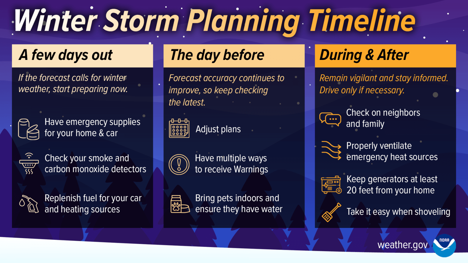
A simple timeline showing how to prepare for winter weather before it arrives, as colder conditions become more likely across Texas.
Winter is finally making a meaningful appearance in Texas.
The weekend has the potential to bring disruptive cold and winter weather, especially across the northern half of the state. Now is the time to start paying closer attention, reviewing weekend plans, and preparing for cold weather impacts.
Updates will continue as confidence improves and details become clearer.
Stay informed. Stay flexible. And don’t panic. This is Texas winter weather doing what it does best.