
The Brief
After a chilly Monday with lows in the 20s and 30s, temperatures will gradually rise through Wednesday before the next round of rain arrives.
A powerful cold front will move through late Friday, causing temperatures to plummet and transitioning ongoing rain into a wintry mix of freezing rain and sleet.
Expect slick conditions through Saturday as temperatures stay below freezing, with a high risk of black ice on area roads Sunday morning before a final thaw begins next week.
DALLAS – North Texas is bracing for a return to winter-like conditions as a series of cold fronts prepare to move through the region. Here is a look at the week ahead and the potential for a wintry mix this weekend.
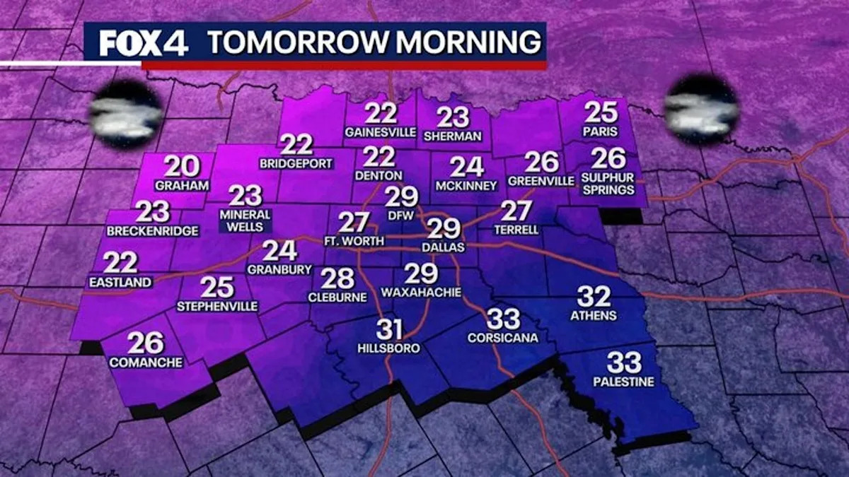
Monday Forecast
Monday will be breezy and cool following a weak cold front, with highs reaching the low to mid-50s. Another freeze is expected Monday night as lows drop into the mid-20s and low 30s, according to the National Weather Service.
Remember to protect the “four Ps”: People, pets, pipes, and plants.
7-Day Forecast
Temperatures will gradually warm through midweek before rain chances return Wednesday. A disturbance will bring the highest coverage of rain to areas south and east of DFW.
By the end of the workweek, an arctic air mass will invade from the north. As temperatures tumble Friday night, ongoing rain is likely to transition into freezing rain or sleet.
Dallas Weather Weekend Outlook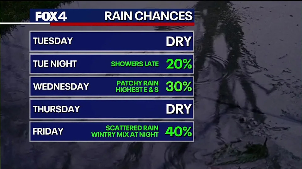
What we know
Temperatures are expected to fall in the early morning hours of Saturday.
As it gets color, any icy rain become more sleet and we may even see some snow. Chances are higher the farther north you go.
While conditions will dry out by Sunday, morning temperatures well below freezing mean ice will likely remain on area roads.
Most of the region will climb back above freezing Sunday afternoon. But, any remaining moisture will refreeze overnight into Monday. A more significant warmup early next week should melt any lingering icy spots.
What we don’t know
The winter weather is still a long way out, so it is too early to give estimates on the exact timing and amount of wintry precipitation we could see.
What is still unclear is the timing of this Arctic air and exactly how cold it will get? We also don’t know how much moisture will be available and the exact timing regarding precipitation.
A change in a few degrees or if the system speeds up or slows down could significantly impact the forecast.
Right now, everything is on the table from rain to freezing rain/sleet and even some snow, but it is far from a guarantee.
The Source
Information in this article comes from the National Weather Service and the FOX 4 Weather team.