
If you’ve been enjoying the relatively mild winter so far across Texas, that chapter is about to close.
A major cold snap is on the way later this week, and confidence is increasing that a widespread winter weather event will impact a large portion of the state heading into the weekend. This is not a “watch the models for fun” situation anymore. We are now firmly in the phase where planning ahead makes sense, especially for travel and cold-weather preparedness.
This article is meant to walk you through what we know right now, what we don’t know yet, and what actually matters for everyday Texans.
Short-Term: Rain First, Cold Later
Before winter weather becomes the headline, Texas has one more relatively quiet weather system to get through.
Late tonight into Wednesday, rain will spread across much of the eastern half of the state. This includes East Texas, Southeast Texas, and parts of the Brazos Valley. Rain totals generally look modest, but some areas could see up to around a quarter inch, with locally higher amounts possible.
This rain is not expected to be severe. There’s no flooding concern, no winter precipitation, and no severe storms with this midweek system. One upside is that it should help temporarily reduce wildfire danger, which has been an ongoing concern across much of Texas.
Once this system moves out, attention quickly shifts to what arrives late Friday.
The Bigger Picture: A Classic Texas Winter Setup
Later this week, a strong Arctic cold front will push south through the Plains and into Texas. On its own, that would simply mean very cold, windy conditions.
The complication is what happens after the cold air arrives.
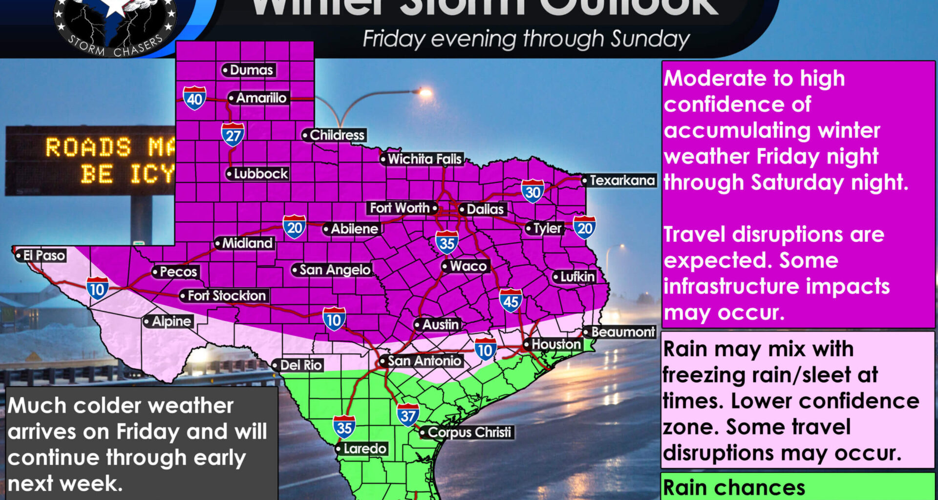
Confidence is increasing in an impactful winter storm this weekend, with travel disruptions likely late Friday through early Sunday, especially across North Texas.
At the same time the Arctic air settles in, a separate storm system is expected to develop to the southwest and move across Texas. This system will bring widespread precipitation, and because cold air will already be in place near the surface, a classic Texas winter weather scenario becomes possible.
In plain terms, this is the type of setup that can produce multiple precipitation types across the state:
Snow where the cold air is deep enough, especially in the Panhandle
Sleet where warm air aloft briefly melts snow before it refreezes
Freezing rain where surface temperatures remain below freezing
Cold rain where temperatures stay just warm enough
The exact placement of those zones is still uncertain, but confidence is growing that travel impacts are likely for a large portion of Texas.
Timing: When Things Go Downhill
Based on current data, the most concerning period begins Friday evening and lasts through Saturday, with lingering impacts into Sunday.
Friday afternoon and evening: Cold front pushes south. Temperatures drop rapidly behind it, especially across West Texas, the Panhandle, and North Texas.
Friday night into Saturday: Widespread precipitation develops as temperatures fall below freezing across much of the state.
Saturday: The worst travel conditions are expected, especially across the northern half of Texas.
Saturday night into Sunday: Precipitation tapers off, but bitter cold remains.
Sunday afternoon: Some improvement possible, but any melting will refreeze Sunday night.
For many areas, this is shaping up to be a multi-day event rather than a quick hit.
Who Is Most at Risk Right Now?
While exact lines will shift, here’s how things are generally shaping up at this point:
Highest Confidence for Significant Impacts
Texas Panhandle
West Texas
Northwest Texas
Texoma
North Texas
Big Country
Concho Valley
These areas are most likely to see prolonged freezing temperatures, snow or sleet, and dangerous travel conditions.
Mixed Winter Weather Risk
Hill Country
Central Texas
Brazos Valley
Parts of East Texas
Southeast Texas into the Golden Triangle (along/north of I-10)
These regions are currently favored for freezing rain and sleet, which can be more disruptive than snow due to ice buildup on roads, trees, and power lines.
Lower Risk but Still Cold
South Texas
Rio Grande Valley
These areas are expected to stay mostly rain initially, but temperatures will still fall sharply, and freezing conditions are possible farther north than usual.
How Cold Are We Talking?
This will be a serious cold snap, though it does not currently resemble a repeat of February 2021. We won’t be dealing with temperatures twenty degrees below zero. We won’t be below freezing for a week, and we won’t have snow down in Brownsville. That being said, we will be dealing with cold-weather hazards this weekend.
That said:
Many areas north of Interstate 10 could remain below freezing for multiple days
Overnight lows in the single digits and teens are possible across North and West Texas
Wind chills could drop below zero at times
Daytime temperatures on Saturday may fail to reach freezing across large parts of the state
Even where winter precipitation is limited, the cold alone will be impactful.
Why Travel Could Be a Problem Even After the Snow Stops
One of the biggest issues with this setup is what happens after precipitation ends.
Any melting that occurs Sunday afternoon will refreeze quickly after sunset as temperatures plunge again. This means roads that appear improved during the day could turn into solid ice Sunday night into Monday morning.
If you’re in the northern half of Texas, Saturday is not a good travel day, and Sunday night could be just as problematic.
What You Should Be Doing Now
This is the window for preparation, not panic.
Start planning alternatives for weekend travel
Make sure pipes, outdoor faucets, and irrigation systems are protected
Check heating sources and backup power options
Have food, water, and blankets ready in case of power interruptions
Keep pets and livestock plans in mind
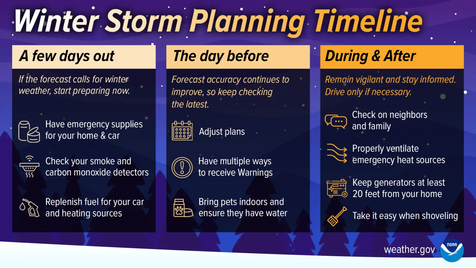
A simple timeline showing how to prepare for winter weather before it arrives, as colder conditions become more likely across Texas.
We will refine details over the next few days, including precipitation types and impact corridors, but the overall signal for cold and winter weather impacts is strong.
Bottom Line
Texas is heading into its most significant winter weather threat of the season so far.
Confidence is increasing in:
A major cold snap beginning Friday
Widespread winter weather impacts late Friday through Saturday
Dangerous travel conditions, especially across the northern half of the state
Prolonged freezing temperatures lasting into early next week
Details will change, but the need to prepare will not.
We’ll continue updating as confidence increases and finer details become clearer. Stay informed, avoid the hype, and use the next few days wisely. You can stay tuned with the free Texas Storm Chasers mobile app.