
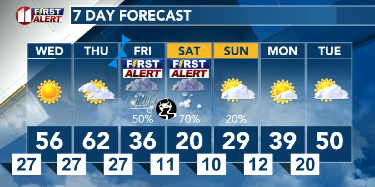
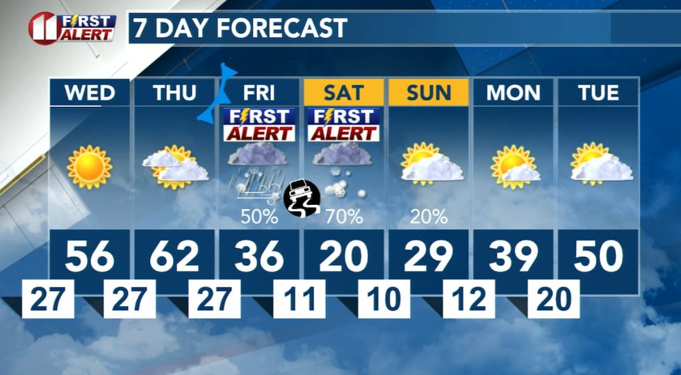
LUBBOCK, Texas (KCBD) – What may be a significant winter weather event will impact the KCBD/FOX34 viewing area late this week and weekend. This storm will bring our area its lowest temperatures so far and may bring significant wintry precipitation.
The Calm Before
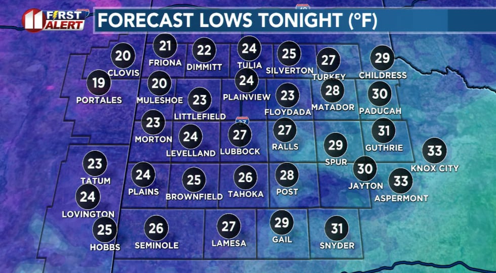
Before the noted changes, a period of seasonably mild weather. Tonight won’t be as cold, this morning Lubbock dipped to 16 degrees, Muleshoe 7°, Friona and Vigo Park 8°, and Hart 9°. It will be clear, the wind southwesterly around 10 mph, lows near average for the time of year.
 Not as cold tonight, with lows near average for the time of year.(KCBD First Alert)
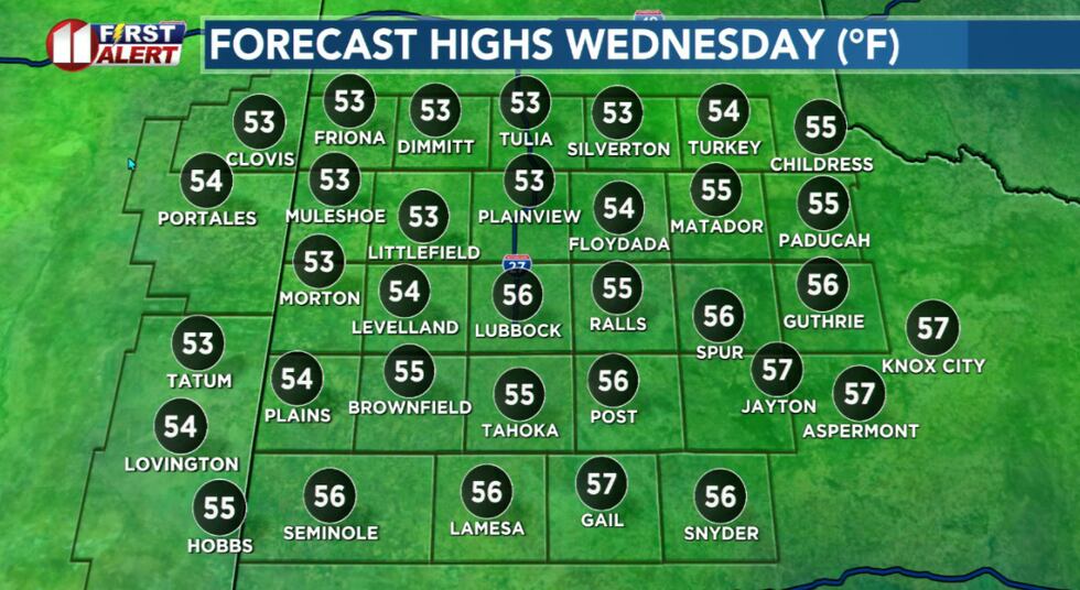
Mild conditions return tomorrow afternoon, a near repeat of today. Under a sunny sky temperatures will again peak near seasonal averages. Winds shift to the north at about 10 to 20 mph.
 Mild afternoon with near average temperatures.(KCBD First Alert)
Quiet weather, including mild temperatures for the time of year, highlight our forecast for Thursday. The afternoon will be a little warmer, again with a bit of an afternoon breeze.
First Alert Weather Days
The First Alert Weather Team is designating Friday and Saturday as First Alert Weather Days. We want to call your attention to the potential for impactful weather during that time.
The strongest cold front of this season – so far – will arrive Friday morning. Temperatures will fall throughout the day. Highs will happen just after midnight Friday (morning). Lows for the day will happen just before midnight Saturday.
 What may be a significant winter weather event will impact the KCBD/FOX34 viewing area late this week and weekend.(KCBD First Alert)
The cold air, combined with a weather system approaching from the southwest, is likely to bring a mix of wintry precipitation to West Texas, including the KCBD/FOX34 viewing area.
The precipitation may begin as early as Friday morning, though late afternoon or early evening looks a little more likely. The initial precipitation may fall as sleet or freezing drizzle or light rain. Some snow may mix in overnight as temperatures drop.
This mix may result in a layer of ice on roads and other surfaces. This would, of course, potentially create hazardous travel conditions. It’s possible this may affect the work/school commute, mainly in the afternoon and evening. Plan accordingly. If you plan on driving, check that your vehicle is winter-ready, drive to conditions, slow down, allow extra travel time, and extra space between vehicles.
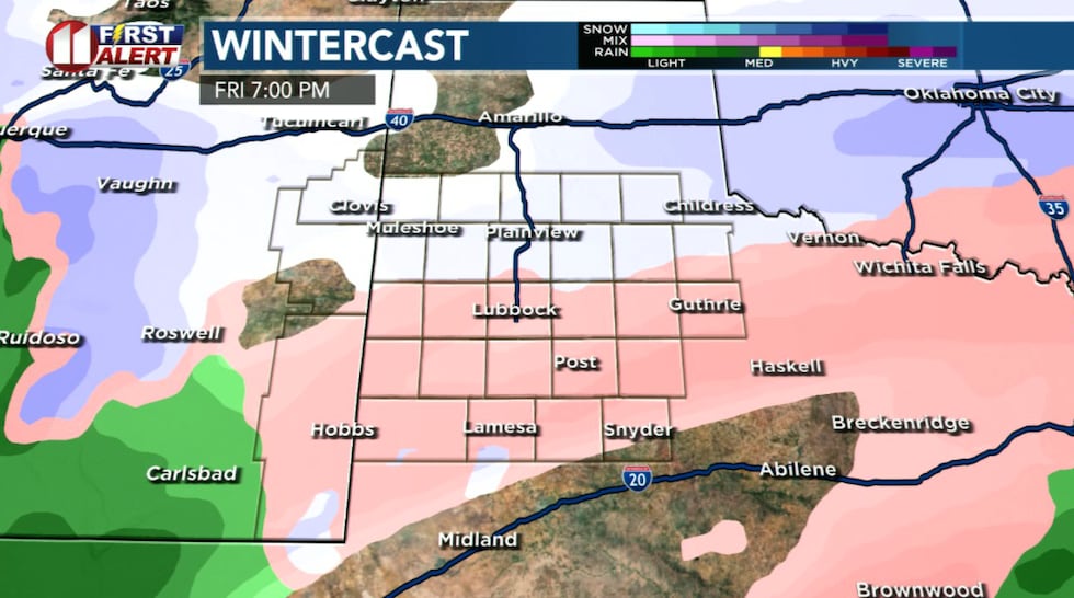 Wintry precipitation is likely to develop Friday.(KCBD First Alert)
Preparation
Limit time outdoors during extreme cold and dress in layers that cover your skin. More layers mean more layers of air to contain your body heat. Check on family, friends, and neighbors to make sure they’re prepared. Monitor our First Alert Weather forecasts for updates as conditions develop.
A reminder ahead of the cold weather arriving at week’s end, the 4 P’s of Cold Weather: People, Pets, Plants, and Pipes. If you are not already, you have several days to prepare. I expect this to bring us our lowest temperature so far this winter. For Lubbock, that was Tuesday morning’s low of 16°.
As I mentioned here yesterday, everyone wants to know how much snow? And this far out, we always say, it is too early to say. That said, IF everything comes together as guidance continues to suggest, some snow is likely for much if not all of the viewing area.
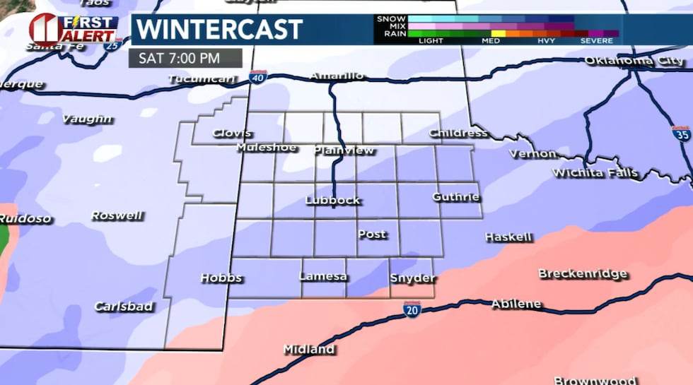 Hazardous travel conditions are possible Saturday into Sunday morning.(KCBD First Alert)
Compared to yesterday, there are some changes to possible amounts. Guidance today is ranging from around 3 to 8 inches in the area. Now, that doesn’t mean that your location will receive that much snow. It’s a possibility in the South Plains area. A small change in the track of the weather system (coming from the southwest) may make the difference in this event shutting down the town to it’s no big deal.
Another issue with forecasting snow amounts is based in how the models handle wintry precipitation. If forecast temperatures are 32° or below, most models will translate the moisture in all types of precipitation to it’s snow equivalent. Even if the precip is rain, freezing rain, or sleet. The earlier the precip changes over to snow the more snowfall there is likely to be. If it doesn’t change over until later, the less snowfall there will be.
One thing I do have high confidence in is it is going to get cold Friday, will be coldest Saturday, and won’t warm much Sunday. Down at the surface where we live it certainly will be cold enough for snow. You might find today’s “On This Date”, below, of interest.
On This Date
On this date in 1983, an incredible snowstorm paralyzed almost all of the Texas South Plains and Panhandle from the 20th through the 21st. This was undoubtedly the largest storm in some time, dropping more than eight inches of snow over such a large area. The heavy wet snow shattered snowfall records in Lubbock with 16.3 inches accumulating. Snow on the ground prior to this storm created a deep snow pack of 25.0 inches at the Lubbock Airport. Plainview measured 18 inches. Prior to the snow, sleet and freezing rain fell over the region resulting in extremely slick roads. Surprisingly, no casualties were reported, but property losses were estimated in the several millions of dollars. Ground and air travel ground to a halt, stranding many people. The very wet snow also collapsed a number of roofs, both residential and commercial. Snow-laden tree branches fell on power lines knocking out power to several communities. Hitting on a Thursday and Friday, school kids were perhaps the most elated as they received a four-day weekend to play in the historic snow.
(Source: National Weather Service, Lubbock)
Copyright 2026 KCBD. All rights reserved.