
FORECAST HIGHLIGHTS
DRIZZLE & FOG THIS AM: Damp morning commute, light showers today
COLD FRONT OVERNIGHT: Front arrives around midnight
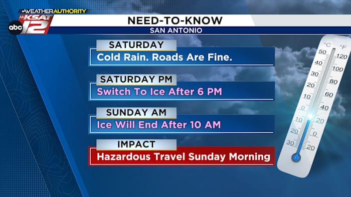
EARLY SATURDAY: Rain and even a few storms, falling temperatures
SATURDAY AFTERNOON: Cold rain in SA, switchover to ice in Hill Country
6PM SATURDAY-EARLY SUNDAY: Ice possible in San Antonio, travel discouraged
FORECAST
TODAY
Patchy drizzle and shower activity will be possible through the rest of today. Temperatures will peak near 70°.
TONIGHT – COLD RAIN, FEW STORMS
A strong cold front will sweep through the area around midnight. Showers and storms will arrive with the front and a strong storm or two can’t be ruled out. Some localized heavy rainfall is also possible. Gusty winds and a rapid drop in temperatures directly follow the front. By Saturday morning, San Antonio’s temperatures will fall into the 40s, with wind chill values in the 20s.
SATURDAY – COLD RAIN FOR SAN ANTONIO, ICE BEGINS FOR HILL COUNTRY
Saturday’s Forecast (Copyright KSAT-12 2026 – All Rights Reserved)
Any heavy rain will push east by early Saturday, but light showers will remain around the area into the afternoon. Meanwhile, temperatures will continue to fall, dropping to freezing in the Hill Country by late afternoon. Light freezing rain will be possible there. For San Antonio, it’ll stay a cold rain until sunset.
HILL COUNTRY: Rain will switch to ice Saturday morning
SAN ANTONIO: Rain will switch to ice Saturday night (Copyright 2026 by KSAT – All rights reserved.)
SATURDAY NIGHT & EARLY SUNDAY – ICE POSSIBLE FOR EVERYONE
Temperatures in San Antonio will drop to or below freezing after sunset Saturday. At this time, a heavier band of precipitation is forecast to move across the area. Freezing rain is expected and some accumulation is possible. Bridges and overpasses will likely become dangerous and should be avoided overnight Saturday and early Sunday. The Hill Country could see heavier amounts of ice, leading to moderate impacts such as isolated power outages.
Ice impacts will be greatest in the Hill Country (Copyright 2026 by KSAT – All rights reserved.)
VERY COLD MONDAY AND TUESDAY MORNINGS
Skies are forecast to clear late on Sunday. This will allow for temperatures to plummet Sunday night and into Monday morning. Currently, we are expecting temperatures in the teens and 20s. Wind chill values may be in the single digits by Monday morning. You’ll want to cover any exposed pipes, drip your faucets, and prepare for bitter cold. Tuesday morning will also see lows in the teens and 20s.
The latest extended forecast from Your Weather Authority (Copyright 2026 by KSAT – All rights reserved.)Daily Forecast
KSAT meteorologists keep you on top of the ever-changing South Texas weather.
QUICK WEATHER LINKS
Copyright 2026 by KSAT – All rights reserved.