
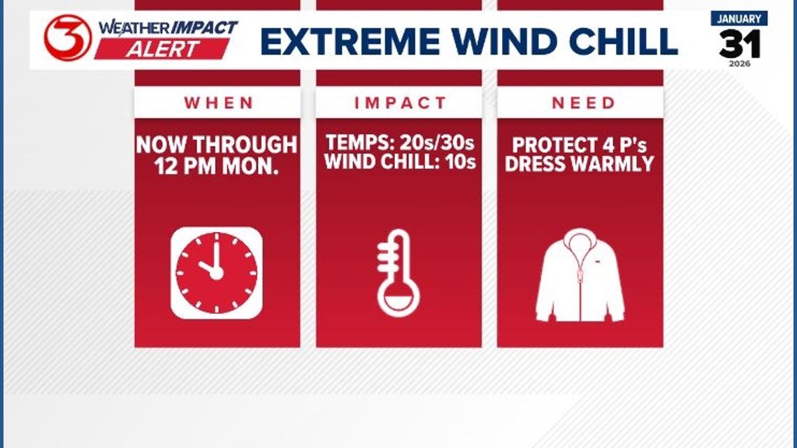
Weather Impact Alert for Dangerous Wind Chills in South Texas. Lows fall into the 20s and wind chills in the teens for the Coastal Bend morning.
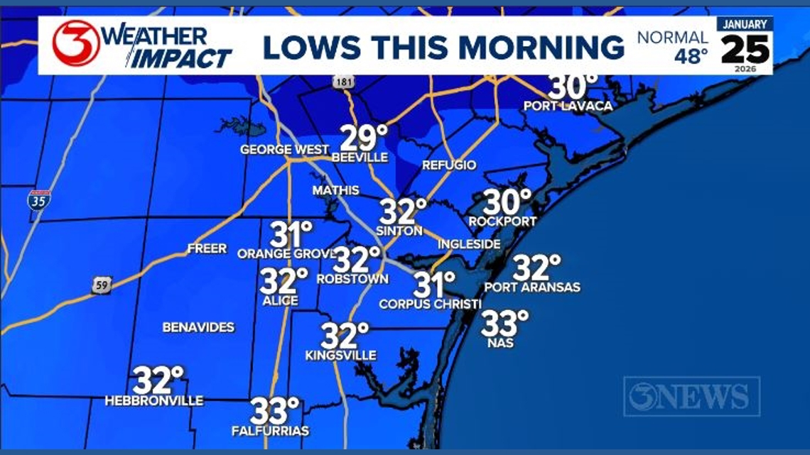
CORPUS CHRISTI, Texas — Corpus Christi did fall below freezing for about six hours early Sunday morning. There was some freezing rain at the time temperatures were below freezing. We had isolated areas with light ice accumulation this morning. All airports hit 32 degrees or colder, except Falfurrias and Flour Bluff. The rain has moved out of the area, and freezing rain is no longer a threat.

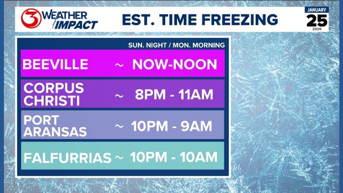
Beeville has stayed at or below 32 degrees all day, and another 18 hours is likely. Temperatures Sunday night into Monday morning are expected to fall into the low and mid-20s in the Coastal Bend. This is pipe-bursting cold. Our rule-of-thumb for freezes and wrapping pipes is either (1) air temperatures of 21-28°F for 4+ hours or (2) air temperatures of 20°F or below.

The good news is that there is no precipitation tonight. Road conditions will be fine; however, it is possible that a puddle freezes in your neighborhood. Drive with caution, but bridges will be fine tomorrow, even though it will be colder, because there will not be any rain tonight. Now, areas north of I-10 will likely continue to see issues from the wintry mix they saw this weekend.

High pressure is building to our north, and that will continue to send arctic air down the plains. This is why the National Weather Service has issued an Extreme Cold Warning tonight through noon on Monday.
The wind will be out of the north-northwest at 8-18 mph, resulting in wind chills at least 10 degrees colder than the air temperature tonight.

RELATED: School closures/delays in the Coastal Bend-area due to winter storm
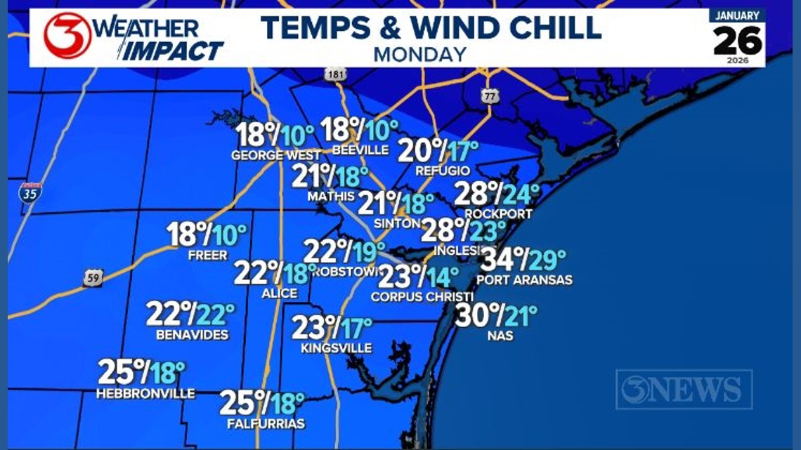
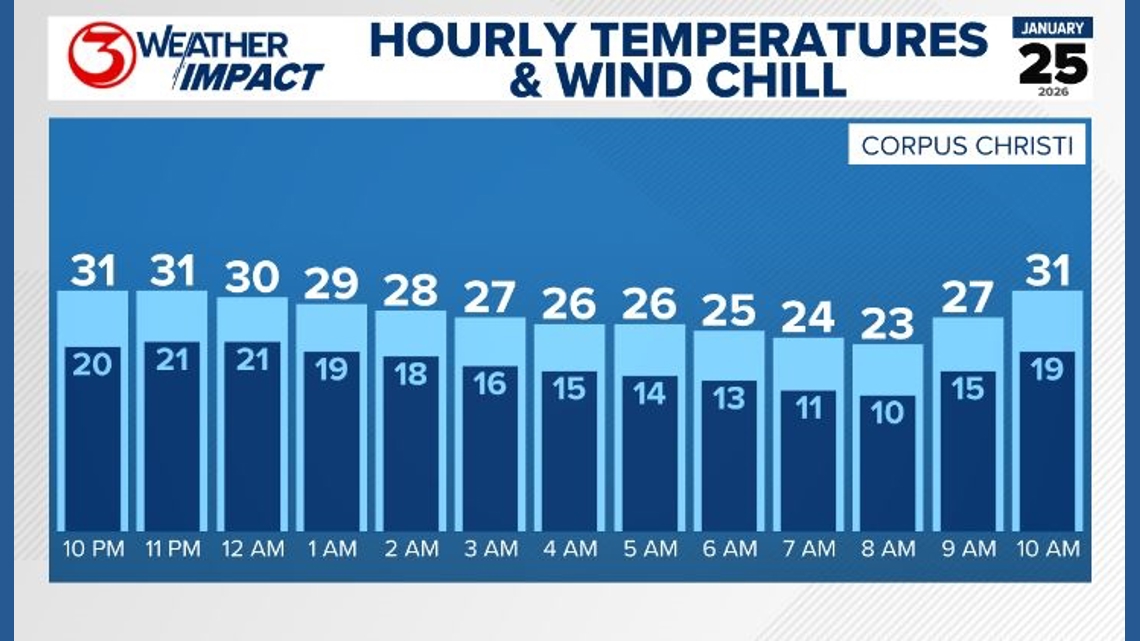
It’s possible the air temperature will reach the teens in Bee and Live Oak Counties around 7 AM on Monday morning. A record low will be possible in Corpus Christi if we reach 23 degrees.
Temperatures will warm back above freezing on Sunday afternoon, but it will still be very cold with wind chills in the 20s and 30s all day. The previous record is 23°F, set in 1897. The record low on Tuesday morning was also set in 1897 at 22 degrees, so that may be challenged as well.
Tuesday morning will be similar to Monday, except we are expecting lighter winds. This may allow radiational cooling to take the temperatures way down into the 20s once again.
If you haven’t finished preparing your home, you still have time before we see a hard freezing Sunday night.
• Drain and wrap exterior pipes, and cover exterior faucets. Drain sprinkler systems and check your pool equipment, too.
• Ensure pets and livestock have adequate warmth and shelter, or bring them inside if at all possible.
• Cover sensitive vegetation and bring potted plants inside.
• Drip indoor faucets during freezing temperatures. Do not drip outdoor faucets.
• Open cabinetry with plumbing inside to allow warm air to circulate around the pipes.
• Make sure you leave your heat on at least 55°F, even if you won’t be home.
Stay safe, and stay warm.
TROPICS: The Atlantic Hurricane Season ended on November 30, 2025. Year-round, you can find updated info on the tropics over on our tropical page.
If you missed the 2025 Hurricane Special or want to see it again, you can always watch it on our streaming service, 3NEWS+. It’s free to download on your smart tv, Roku, or Firestick. It’s also on YouTube.
RELATED: What is a 3NEWS Weather Impact Alert