
LUBBOCK, Texas (KCBD) – Lubbock, and much of the area, made it above freezing this afternoon. For Lubbock, it was the end of four full days of freezing temperatures (at or below 32°F). While it is one of the City’s longer periods, it was no where near the record. See the table below for the longest. Warmer and dry weather highlight our forecast the rest of the week.
96 Consecutive Hours
Lubbock (measured at the airport) dropped to 32° at 12:25 PM Friday. The temperature finally climbed above 32° today (Tuesday) at 12:35 PM. The longest stretch at/below 32°F in Lubbock’s record is 8 days (207 consecutive hours) in December of 1983.
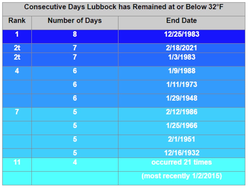 8 days, 207 hours in the longest period in Lubbock’s record (dating from January 1911) at or below 32°.(KCBD First Alert)
Patchy Ice Tonight
First, though, another very cold night. With temperatures dropping below freezing not long after sunset, the slush and water that remains will quickly refreeze.
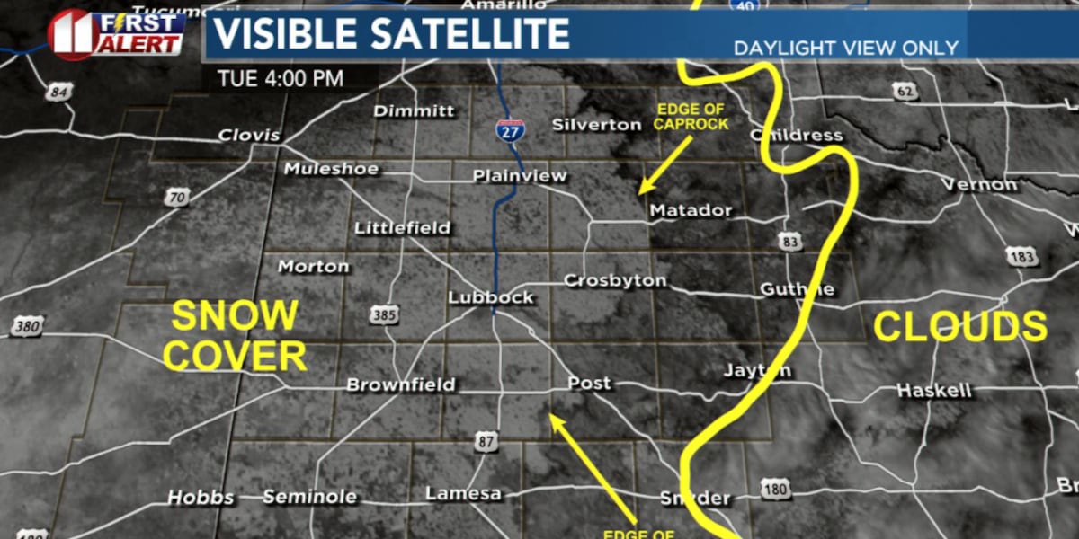
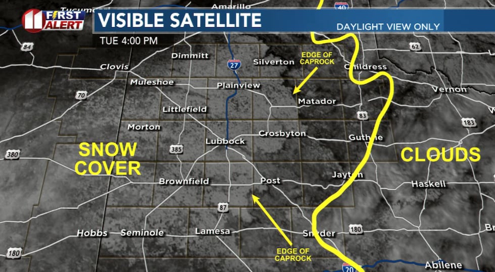 The darkest areas in the image is bare ground. The shades of grey left of the yellow line is snow cover.(KCBD First Alert)
In these areas, hazardous road conditions are likely past sunrise tomorrow, Wednesday. Under a clear sky, and with a light wind, areas of freezing fog may develop tonight.
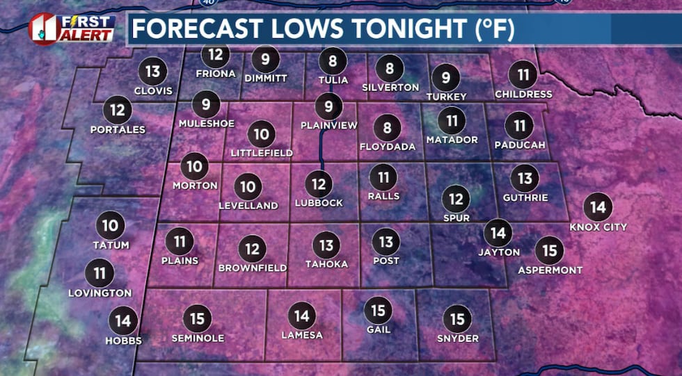 Another very cold night for the KCBD area. Moisture and slush that remains will result in icy areas tonight and Wednesday morning.(KCBD First Alert)
Warming Begins
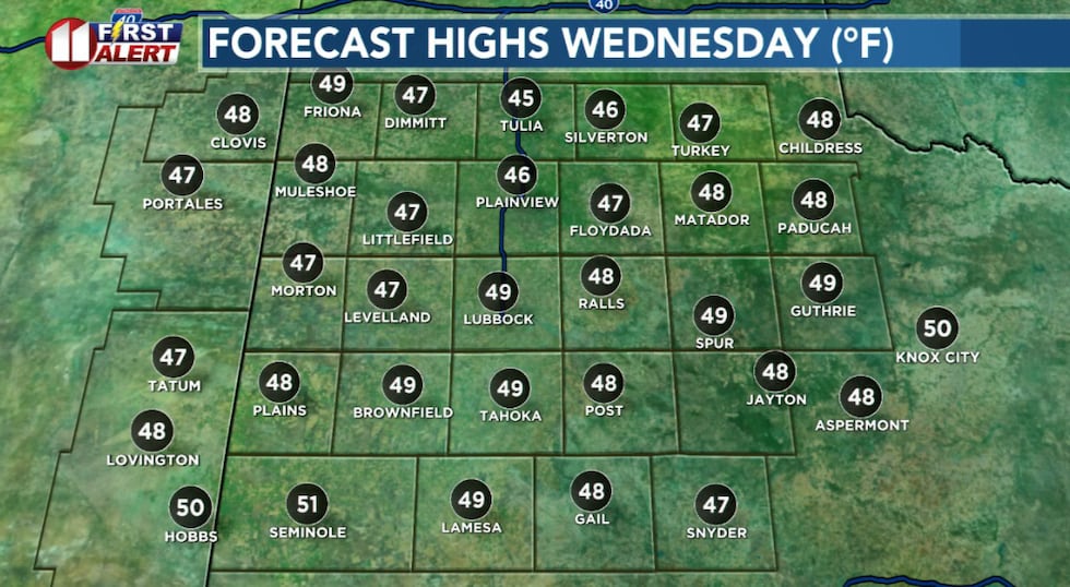
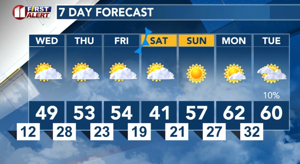
Wednesday brings mostly sunny skies and our first significant warming. Highs will reach the 40s in most areas. Where several inches of snow remains on the ground temperatures may not quite make it past 40. Where there is no snow or significant snow on the ground, temperatures may climb above 50 degrees.
 More sunshine and a slightly warmer afternoon.(KCBD First Alert)
I expect more sunshine than today. With a light west then southwest wind, it should be a somewhat pleasant afternoon to be outside.
Late Week
Clouds will increase Wednesday night, but it won’t be as cold.
Thursday and Friday will bring more sunshine, though there may be a bit of a breeze each day. Temperatures will peak a little below average for the end of January.
Weekend Outlook
The weekend stays dry and mostly sunny. Saturday will be cooler following a cold front, but Sunday temperatures quickly bounce back to nearly average for the first of February.
 Dry and warmer weather ahead!(KCBD First Alert)
Enjoy the dry pattern and warming trend this week. No rain or snow currently is in sight, and temperatures are on an upward trend heading into next week. As always, we encourage you to watch for later forecasts and possible updates.
On This Date
On this date in 2001, a strong upper level low pressure system moved into the Southern Rockies from the west while cold air spread into West Texas from the north. Precipitation began as freezing rain early and by late afternoon resulted in a heavy glaze on outside surfaces.
The freezing rain changed to snow over the northwestern South Plains, with between four and eight inches of snow on top of a quarter inch of ice. The freezing rain continued across the rest of the South and Rolling Plains into the following morning. Between a quarter to an inch of ice glaze accumulated on exposed surfaces. The precipitation finally changed to snow before it ended with one to three inches accumulating on top of the heavy glaze. Some brief power outages were reported as heavy ice brought down power poles, power lines, and trees.
(Source: National Weather Service, Lubbock)
Copyright 2026 KCBD. All rights reserved.