
LUBBOCK, Texas (KCBD) – A weak cold front tomorrow will drop our high temperatures slightly before a warm up gets under way. Late week high temperatures will be the warmest here since the start of the year.
Tonight
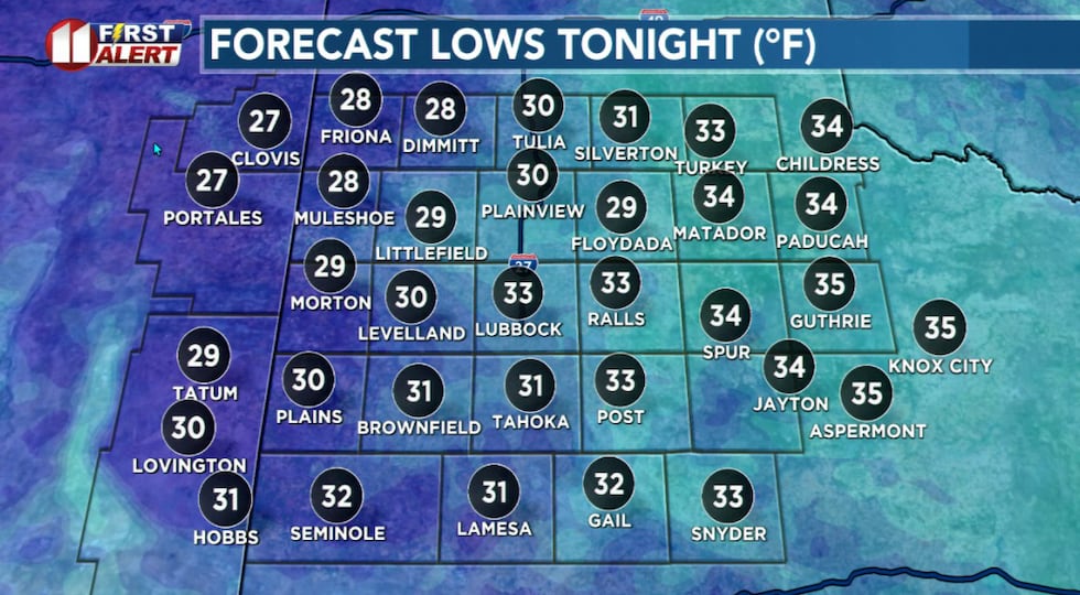
Cloud cover will increase late tonight, bring a slight chance for patchy drizzle early Wednesday morning. No wintry showers are expected, though air temperatures may briefly dip to near or just below freezing in the northwestern viewing area.
 A little colder tonight.(KCBD First Alert)
A typical low this time of year around Lubbock is 29°. I expect a light wind, less than 10 mph, mostly from the southeast.
Wednesday
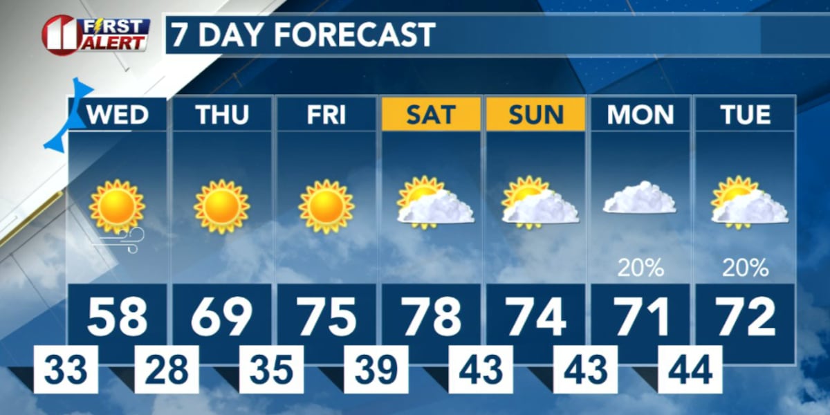
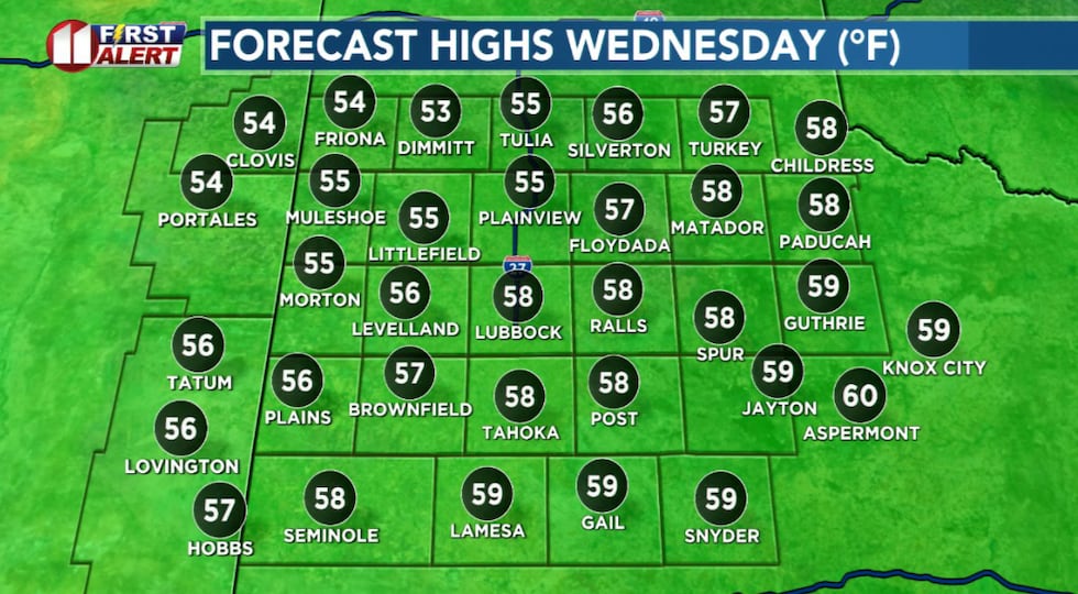
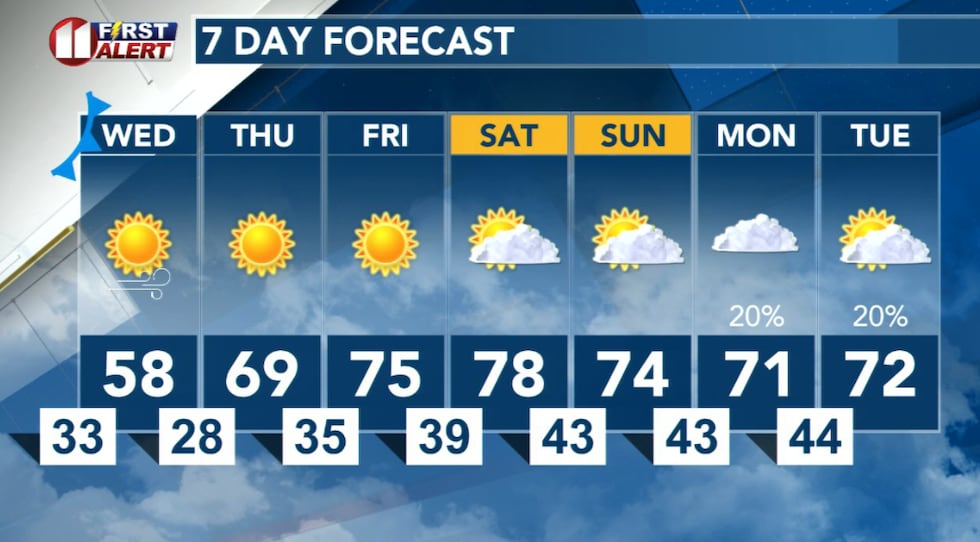
The cold front mentioned previously will pass north to south through the area before noon tomorrow. Winds will become breezy, switching to northerly with speeds increasing to around 15 to 25 mph. Gusts around 35 mph are likely.
 A little cooler Wednesday with highs near average for the date!(KCBD First Alert)
The clouds which may support the drizzle mentioned are expected to clear with a sunny afternoon. Though cooler, highs from the mid-50s to near 60 degrees are pretty much average for early February.
The daytime cooldown will be followed by a somewhat colder night. Thursday morning low temperatures at or below freezing are expected for the entire KCBD/FOX34 viewing area.
The Warm Up
The warming trend begins Thursday. Sunny skies and a westerly breezes will help propel temperatures into the upper 60s Thursday and above 70 degrees Friday.
 A slight cool down before a warm.(KCBD First Alert)
Friday may be the nicest of the two days as I expect a light wind.
Saturday will be the warmest day of the extended period, with highs in the mid- to upper 70s. Temperatures may peak near 80 degrees at spots east of the Caprock.
The Rain Chance
Cloud cover will increase Sunday, dropping temperatures just a bit.
A slight chance of rain returns to the area Sunday night, with the best chance Monday and Monday night. At the moment, the potential for measurable rainfall is low and total amounts light. Still days away, however, so changes are possible.
 The next best chance of rain, still a slight chance, is early next week.(KCBD First Alert)
Enjoy the sunny and warm stretch through Saturday, then watch for that chance of rain Sunday night into Monday.
On This Date
On this date in 1964, though impacts were minimal impacts on the South Plains, one of the worst snowstorms in Panhandle history dumped 18 to 26 inches of snow on portions of the TX Panhandle (from the 3rd through the 5th). The storm blanketed parts of New Mexico, Colorado, Kansas, and the Oklahoma Panhandle. Although not as significant, 5.6 inches was measured farther south in
Plainview, 5 inches at Crosbyton, and a mere 1 inch at Lubbock. Winds in the Panhandle reached 30-35 mph creating blizzard conditions that produced drifts up to 10 feet high in places! At one point on the 6th, all highways leading to Amarillo were closed and many small towns, farms and ranches became isolated from travel for three days. Four persons died during the storm; one in Stinnett from exposure and three near Amarillo, one from a heart attack, another from carbon monoxide poisoning, and one after a man backed his pickup truck into the path of an oncoming train in blinding snow.
(Source: National Weather Service, Lubbock)
Copyright 2026 KCBD. All rights reserved.