
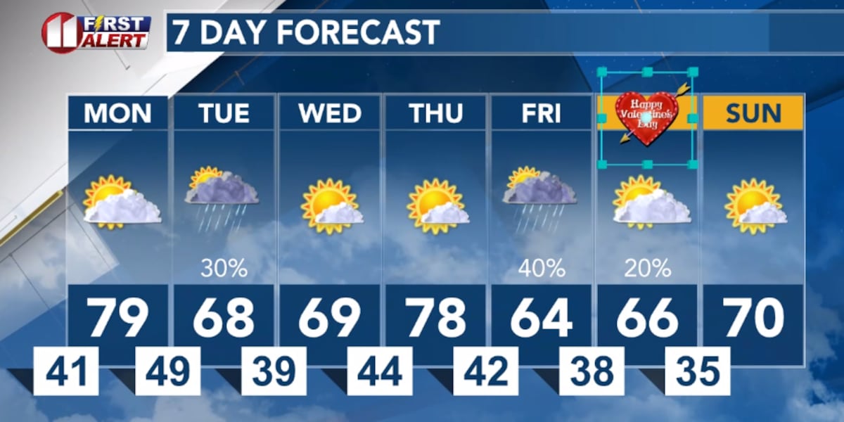
LUBBOCK, Texas (KCBD) – The South Plains will start the week as it ended last week, with well-above average temperatures. A slight shift in the weather pattern will bring a chance of rain Tuesday and again late in the week.
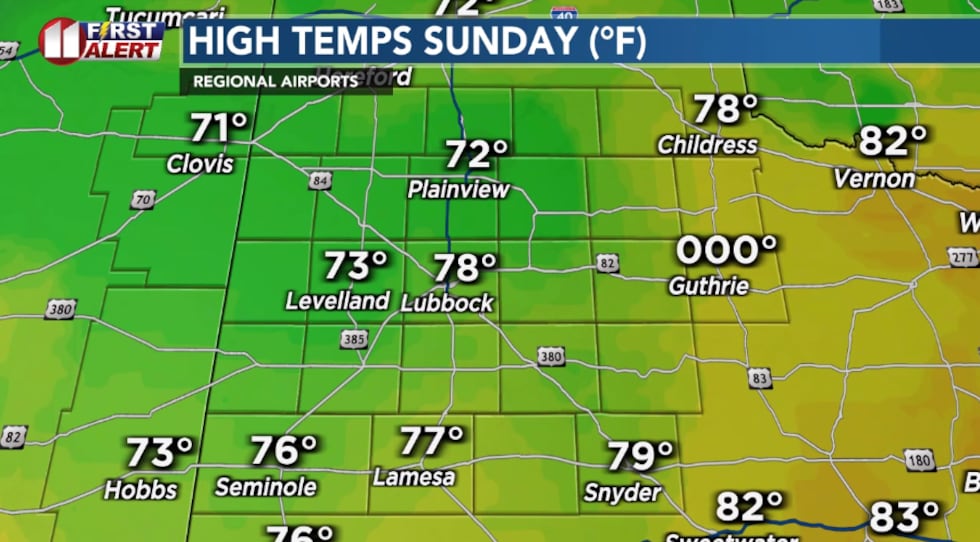 Peak temperatures recorded Sunday afternoon at regional airports.(KCBD First Alert Weather)
Chilly Tonight
Tonight will be mostly clear, winds will remain light, and it will get chilly.
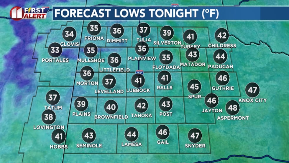 Mostly fair and a little colder tonight. Most areas will be about 10 degrees colder than Sunday morning.(KCBD First Alert Weather)
That said, however, morning lows will end up 10 to 15 degrees above average for the second week of February.
Warm Monday
Monday afternoon will be very warm with a partly sunny sky. The wind will become more of an issue Monday afternoon. Light northwesterly winds in the morning will shift to southwesterly by afternoon and increase to around 10 to 20 mph. Gusts from around 20 to 30 mph are likely as surface low pressure develops over southeastern Colorado.
 The dry, breezy, and very warm weather will create an elevated grassland fire danger Monday afternoon.(KCBD First Alert)
The combination of the breezy winds and upper-level high pressure overhead will contribute to temperatures even warmer than Sunday. Highs around 15 to as much as 20 degrees are expected. While well-above average, highs will fall short of the daily record highs.
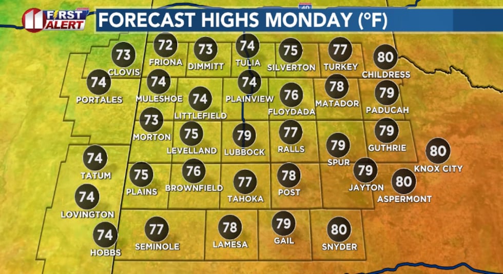 Well-above average high temperatures return Monday.(KCBD First Alert Weather)
Monday night will turn mostly cloudy with lows around 50 degrees – again, well above average.
Rain Tuesday
The first significant weather change arrives Tuesday as moisture from the Gulf of Mexico moves into the region. Expect mostly cloudy skies with a slight chance of showers in the morning, with an increasing chance in the afternoon as a cold front moves through. The rain chance will continue into the evening.
The area with the best chance of measurable rainfall is the southern KCBD/FOX34 viewing area. That said, amounts are expected to be very light. Some spots may pick up a few hundredths of an inch of rain.
The clouds, showers, and cold front, will result in a noticeably cooler afternoon.
Winds will shift from west ahead of the front to north behind the front during the afternoon.
Dry Again
Wednesday reverts to a dry pattern with mostly sunny skies and highs around ten degrees above average. This may be one of our coolest days of the week.
Warm Again
Thursday will be warmer again with mostly sunny skies and highs around 15 degrees above average as an upper-level ridge strengthens. A slight chance of showers, however, develops Thursday evening ahead of the next system.
Wet Pattern
Rain chances increase as the weekend approaches. Friday will be cooler with mostly cloudy skies and scattered showers likely. Highs will take a notable drop as another cold front swings through by early Friday morning.
 Warmer to start the week, then cooler with a slight chance of light rain Tuesday. Cooler again with a better chance of rain late in the week.(KCBD First Alert Weather)
Currently, Friday night appears most likely to be the wettest period.
Valentine’s Day
Some rain showers may linger into Saturday morning, with clearing anticipated by afternoon. Temperatures will be similar to Friday, peaking about five degrees above average.
On This Date
On this date in 2001: Rare for early February, severe thunderstorms produced damaging winds and large hail early in the afternoon across portions of the northern and central South Plains. At least a dozen trees were either snapped or uprooted eight miles north of Olton from winds estimated at 70 mph. Winds also damaged a roof and destroyed a radio antenna at a nearby home. Power lines were blown down in Plainview and hail as large as golf balls fell in Tulia with penny size hail reported in Lubbock and Farwell.
(Source: National Weather Service, Lubbock)
Copyright 2026 KCBD. All rights reserved.