
By Shaun Boyd
History Colorado
Maps hold a special place in my heart.
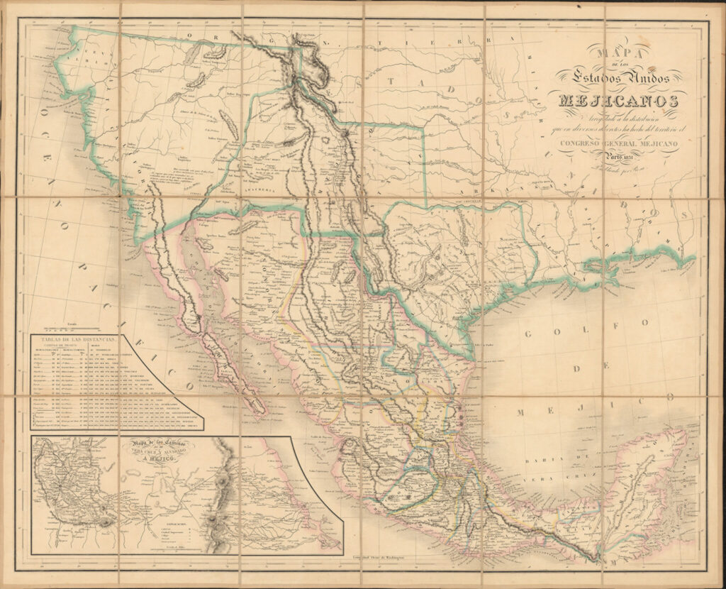
Luckily, I’m one of the curators entrusted with History Colorado’s map collection, and one of my favorites came to the museum sometime between 1915 and 1930. Donated by James F. Willard, a University of Colorado history professor, the map tells the story of negotiations over the border between the U.S. and Mexico following the Mexican-American war and the Treaty of Guadalupe Hidalgo that ended the conflict.
A mistake on this and previous versions of the map misinformed U.S. officials during negotiations with Mexico over the $10 million Gadsden Purchase less than a decade later. It’s a story of human error, and a lesson about the trouble with mapping vast and inaccessible swaths of inhospitable landscape. It’s a moment that reveals the twists and turns of history along a contentious and somewhat arbitrary boundary, and fortunately for map lovers like me, it’s all right there for everyone to see.
![]()
With the ponderous and curious title, Mapa de los Estados Unidos Mejicanos Arreglado a la Distribución que en Diversos Decretos ha Hecho del Territorio El Congreso General Mejicano or Map of the United States of Mexico Adjusted to the Distribution that the Mexican General Congress has made of the Territory in Various Decrees, the map was printed in Paris in 1851. It was the second edition of a map first published by Jean Frederic Rosa in 1837 right after the Republic of Texas was established. The Rosa family were creating them for the Mexican government and other Latin American interests, and bringing the maps to the European market. Rosa’s map was one of three used to locate El Paso and define the U.S.-Mexico border. It’s considered exceptionally rare in map expert circles.
Rosa’s 1837 version copied an earlier 1826 map by Henry Tanner that was based on the work of several explorers including Zebulon Pike. In the 1826 map and later editions, Tanner erroneously moved the location of El Paso further north on the map (it had been correct in the first edition), which doesn’t seem like a big deal, but it would prove to be quite problematic for the U.S.
The 1848 Treaty of Guadalupe Hidalgo ended the Mexican-American War, and the agreement forced Mexico to cede 55 percent of Mexico’s territory, adding millions of acres of land to the United States, including parts of what became Colorado, Utah, California, Nevada, New Mexico, Arizona, Kansas, Oklahoma and Wyoming. The treaty also set the conditions under which the US-Mexico border was taking its shape.
Negotiations between U.S. and Mexican officials over the border’s location used yet another version published by John Disturnell in 1847 (the second map in the series). That map also had the location of El Paso wrong, and since the border was based on a line west of El Paso, that meant that the border itself was in the wrong spot. So all three maps (Tanner, Disturnell and Rosa) had El Paso too far north.
The California Gold Rush in 1849 brought thousands of settlers into this territory just a year later. This land was already the home of Indigenous peoples and former residents of Mexico, who suddenly found themselves residents of the U.S. when the border crossed them.
By 1851, as U.S. investors started looking to build a railroad to connect California via a southern route and link the newly bi-coastal nation, they realized that the best place to put train tracks was, according to their maps, in Mexico. But the mistaken placement of El Paso meant that the US would have to renegotiate and ultimately purchase land from Mexico to make the route possible. The Gadsden Purchase of 1853 created the border that’s so fraught with controversy today. It’s one of the most guarded and politically contested parts of the country, and as it turns out, it might not have needed to be part of the U.S. at all.
Shaun Boyd is History Colorado’s Curator of Archives, Politics, Government. She has worked in Colorado libraries and museums since 1995. Her primary interests are Women’s History, Early Colorado History, and the Progressive Era, as well as maps, ghost stories, and cemeteries.
 Downtown El Paso, Texas on Jan. 19, 2025. (AP Photo/Andres Leighton)