
It’s been an extremely dry fall across Texas, especially in our part of the state. Since Sept. 8, San Antonio has recorded a minuscule 0.01 inch of rainfall, while Austin has gone 45 consecutive days without any measurable rainfall, the city’s second-longest dry streak in the past 10 years.
Things haven’t been much better in East Texas or North Texas. The Dallas-Fort Worth area has recorded 0.66 inch of rain over the past 45 days, more than four inches below the climate-normal. Meanwhile, Houston is more than seven inches below average over the same period.
Long story short: We need more rain. Thankfully, rain chances are about to jump higher than they’ve been in more than six weeks. It’s not all good news, though. This storm system also could bring isolated hail, damaging winds and flooding to many parts of the state. Here’s a breakdown of what to expect.
Thursday night
First of all, besides a few isolated showers along the coast, we don’t really have any chance of rain throughout Texas on Wednesday. Much of Thursday will be dry, too, but a few thunderstorms will start to move into West Texas by Thursday night along with a low pressure system over the desert Southwest starts its approach.
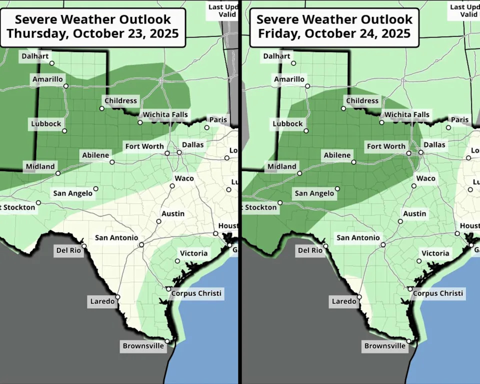
Shown is the severe weather outlook for Thursday, left, and Friday from the National Weather Service’s Storm Prediction Center. (Storm Prediction Center)
By Thursday night, the National Weather Service’s Storm Prediction Center has a portion of West Texas, from Midland-Odessa, north to Lubbock and Amarillo, under a level 1 of 5 risk of severe thunderstorms. That means that while most storms will stay under severe weather thresholds, a few isolated storms could produce hail an inch to 1.5-inches in diameter, along with 60-70 mph wind gusts.
The risk of severe thunderstorms will mainly start after sunset and continue overnight. A few storms may make it to the DFW area by early Friday, but other cities to the south, like San Antonio and Austin, will stay dry.
Friday storms and flooding
The system of low atmospheric pressure out west will move closer Friday, ramping up the rain activity across Texas. During the afternoon and evening, scattered strong storms are expected to develop. Midland, Lubbock, Abilene, and the DFW area are under a level 1 of 5 risk of severe storms. Dallas’ best chance of hail and/or damaging winds will occur between 6 and 11 p.m.
As the night progresses, storms are expected to push south and eastward, toward Austin and San Antonio. The risk of large hail will be quite low, but heavy downpours will result in an enhanced flood threat for much of the state.
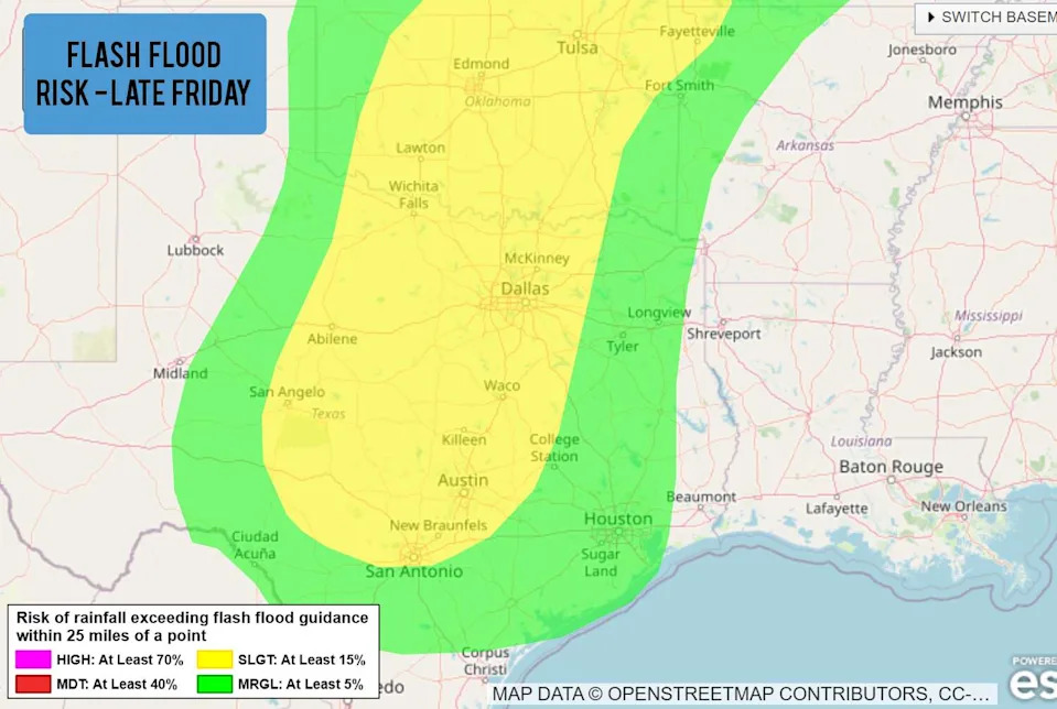
Shown is the excessive rainfall outlook across Texas from Friday evening though Saturday morning. Flash flooding will be possible, according to the National Weather Service’s Weather Prediction Center. (NOAA)
From Friday evening through early Saturday morning, a large area including San Antonio, Austin, the Hill Country, Waco and DFW are under a level 2 of 4 risk of excessive rainfall. That means the area has at least a 15% chance of flash flooding occurring within 25 miles of any point.
While a 15% chance of flooding may not sound entirely too threatening, it represents a real weather risk and something that should not be taken lightly.
For San Antonio specifically, a few isolated scattered storms are possible Friday afternoon and evening, but the threat of widespread thunderstorms and flooding is not likely to begin until after 8-9 p.m. Rain chances will jump to 60-80% in the overnight hours.
On Saturday, the threat of flooding will shift eastward. Cities such as Houston, Beaumont and Lufkin will be under a level 2 of 4 risk of excessive rainfall, and some lingering heavy rainfall will stay possible along the Interstate 35 corridor. By Sunday, most of the rain will have moved out of the state.
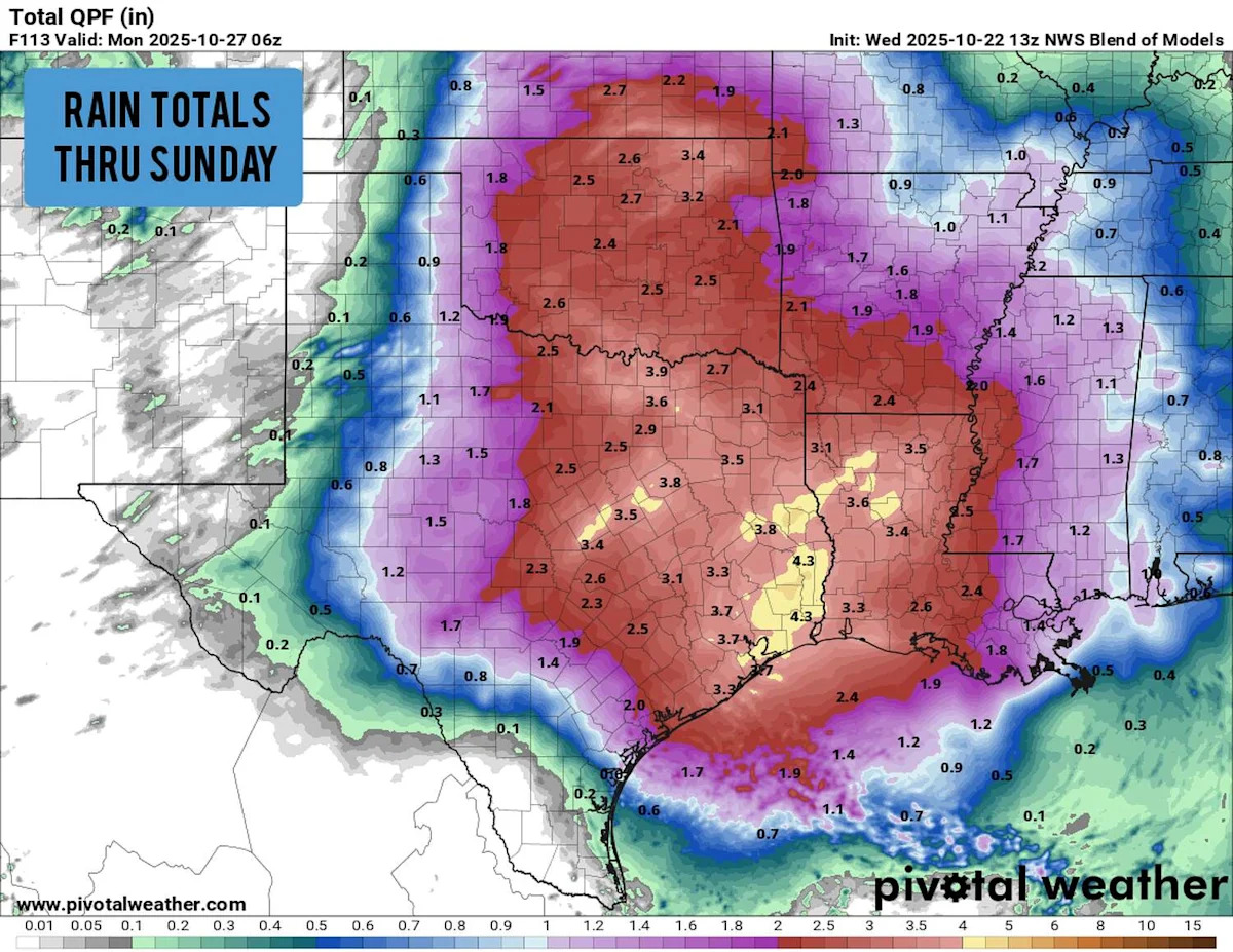
How much rain will fall?
The San Antonio metro area is most likely to see between an inch and 1.5 inches of rain, with most of the rain occurring between 11 p.m. Friday and 9 a.m. Saturday, according to the National Blend of Models. Isolated higher totals of more than 3 inches are possible, especially in the Hill Country.
Rainfall totals will be higher as you push north and east. A wide swath from Waco to Dallas to Houston could receive 2 to 4 inches. Isolated totals of more than 6 inches of rain could cause major flooding for some. Stay with expressnews.com/san-antonio-weather for updated forecasts.
This article originally published at Severe storms, flooding risk aims at Texas by end of the week. Here’s a breakdown..