
Much of northern Texas will be under a flood watch starting Friday evening, from Temple to Sherman.
The watch, issued by the National Weather Service’s Fort Worth office, warns of excessive runoff leading to flooding in rivers, creeks, streams and other low-lying locations. There is also a risk of flooding in urban areas with poor drainage.
Related

The watch will be in effect from Friday evening through Saturday afternoon. No immediate action was recommended by the weather service, but residents should be aware during the watch period for flood warnings.
D-FW Weather Wise
Throughout the entire watch period, most areas are expected to get 2-3 inches of rain, with up to 5 inches possible.
As of Thursday morning, the weather service was predicting the heaviest downpour for Denton and Montague counties, as well as smaller portions of Cooke and Wise counties. Further south, similarly heavy rainfall was forecast for Waco and the surrounding counties.
Related

These estimates could change, the weather service said, depending on how quickly the storm system moves through the region overnight Friday.
Check the graphic below from the weather service to see how much rain is expected to fall in your area.
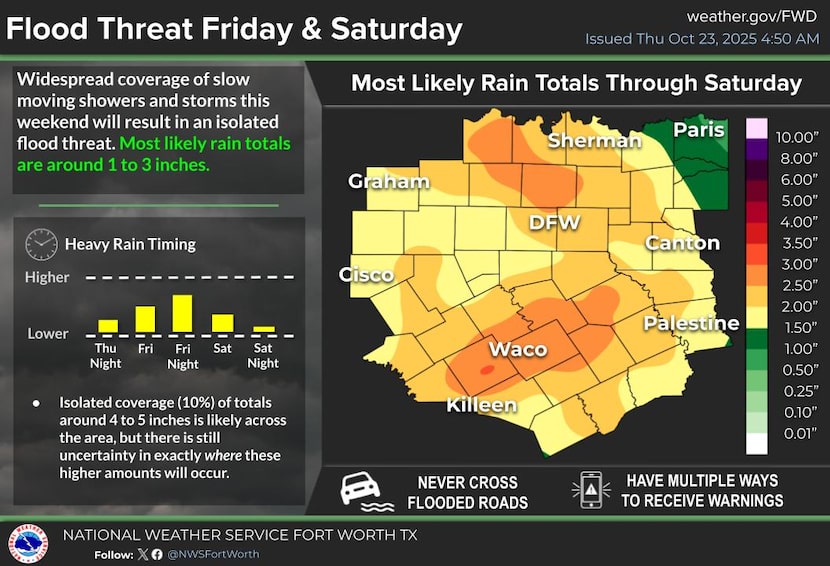
Graphic of expected rainfall totals for Friday, Oct. 24 and Saturday, Oct. 25.
Courtesy of National Weather Service