
A shift in the weather pattern across Texas is happening this week and into the weekend. Projected rainfall totals appear to be substantial, with several inches expected across the state.
Pivotal
The last measurable rainfall in Central Texas fell on Valentine’s Day, marking an 18-day stretch of record heat, extremely dry weather, active wildfires, and rising pollen levels.
Now, the pattern is finally beginning to shift. A series of atmospheric disturbances will bring increasing rain chances to Central Texas starting Wednesday, with daily opportunities for showers and storms lasting through next week. Some forecast models even suggest widespread totals of 2 to 3 inches of rainfall, with isolated spots approaching 4 inches.
Article continues below this ad
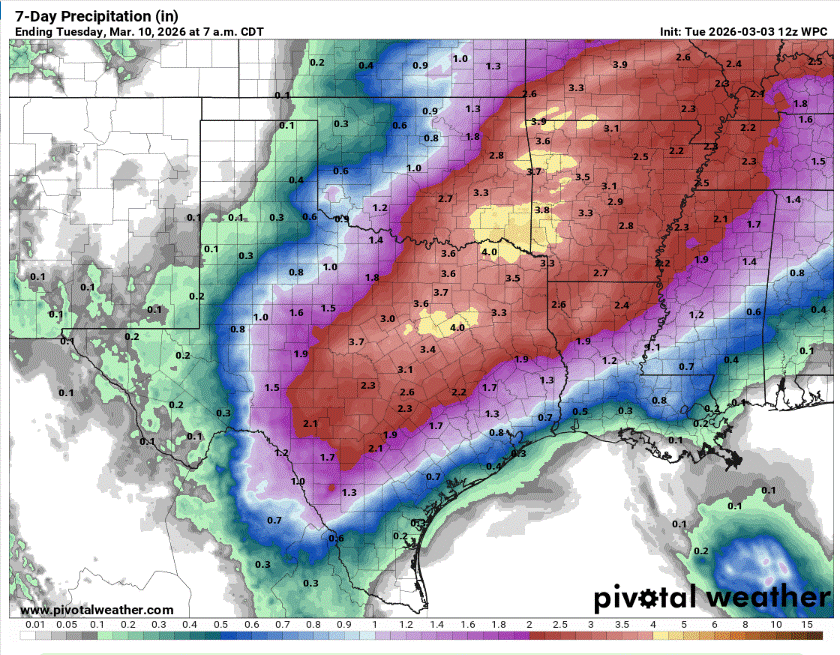
The first heavy rainfall of March will arrive midweek and last through next week with the possibility of up to 3 inches of rain in Central Texas.
Pivotal
That would be welcome news. So far this year, cumulative rainfall totals are running about 3 inches below normal, and that doesn’t include the more than 10-inch deficit from normal carried over from 2025.
Shifting weather pattern
We’ve entered meteorological spring, and March is typically a transition month from winter’s chill to spring’s vibrant greens. That seasonal shift often means warmer temperatures and wetter weather.
Article continues below this ad
The broad system of high atmospheric pressure that dominated last week’s weather in Austin is sliding southeast, allowing the jet stream to dip farther south and push a cold front into North Texas on Wednesday. Meanwhile, a strong trough of low pressure diving out of the Pacific Northwest will dig south, eventually breaking away from the main atmospheric flow and meandering across Southern California. As it does, it will send multiple impulses of energy into Texas before moving overhead by late next week, helping to fuel our rain chances through next week.
An active weather pattern will set up across Texas with rain chances in Austin every day for the next several days.
National Weather Service
Wednesday forecast
The first atmospheric disturbance will move into the central Plains on Wednesday, accompanied by a cold front. That front is expected to stall just north of our area near Waco, causing greater concern for strong to severe thunderstorms. The National Weather Service’s Storm Prediction Center has placed that region under a level 2 out of 5 risk for scattered severe thunderstorms.
Article continues below this ad
Severe storms are possible on Wednesday for areas across North Texas. The biggest threat with any storm will be hail and damaging winds.
Storm Prediction Center
Southerly winds will continue to deliver a steady stream of atmospheric moisture to Austin, leading to overcast skies and drizzle in the morning. By the afternoon, scattered showers and a few thunderstorms will be possible. While the threat for strong storms is lower in Central Texas, it is not zero.
Our area is under the lowest risk level for severe weather through Wednesday, with the main threats being hail and heavy downpours. Daily temperatures will remain above average, with morning temps in the middle to upper 60s and afternoon temps in the lower to mid-80s.
Article continues below this ad
Thursday forecast
Unseasonable warmth and humidity will continue throughout the week. Dew point temperatures, which can indicate atmospheric moisture levels, will remain at or above the 90th percentile, keeping overnight temperatures mild and the air feeling soupy, the National Weather Service said.
Wednesday’s frontal boundary will pull to the north, taking the rain and storm chances with it. Thursday appears to be drier, but with some atmospheric instability and above-normal temperatures, isolated thunderstorms will be possible in the late afternoon.
Weekend forecast
The second storm system responsible for our weekend rain will move into the Intermountain West and then go in two different directions.
Article continues below this ad
“Models remain consistent in the trough (of low pressure) separating into two primary lobes of energy, with a shortwave (disturbance) continuing to advance into the Central Plains and a cut-off low dropping southwest towards the Baja California,” meteorologists at the National Weather Service said in their forecast on Tuesday.
Another cold front will move into Texas on Friday afternoon but will stall across our region on Saturday. Meanwhile, the lagging cutoff low to our west will establish an extended plume of moisture from the eastern Pacific into Texas, with the subtropical jet providing opportunities for spokes of energy to rotate around the cutoff low and track over the state.
Another cold front surges into Texas by Saturday with ongoing rain and storm chances through the weekend.
Weather Prediction Center
This is a favorable setup for periods of showers and thunderstorms from Friday through early next week.
Article continues below this ad
“The latest model blend continues to show about a 50-75% chance for at least 1 inch of rainfall across most of our area this weekend, with the potential for multiple inches in some locations,” the NWS stated. “Deep moisture should be in ample supply, so heavier downpours could be supported.”
As for severe thunderstorms, there will be moderate instability, but thick cloud cover and the potential for heavy rain should temper any widespread severe weather across Central Texas.