
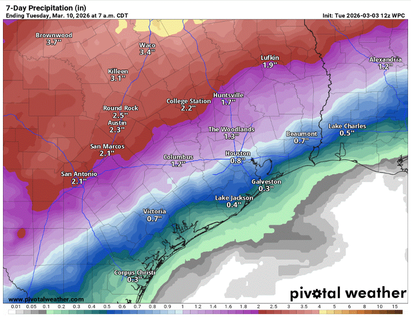
An unsettled weather pattern is expected to take hold and linger through the middle of next week, bringing chances of daily thunderstorms, some of which could turn strong to severe, with pockets of locally heavy rainfall.
The front will retreat back north as a warm front on Thursday, as a stronger upper-level low pressure system moves over the Great Basin and the Rocky Mountains.
In Central Texas, we’ll wake up to overcast skies Thursday, along with light showers and drizzle. These showers might continue through lunchtime before the weather dries up a bit, allowing temperatures to warm into the middle to upper 80s with gusty south winds.
The northern branch of the system will send a dry line — the boundary between dry and humid air masses — into West Texas and the Hill Country on Friday. With sufficient atmospheric instability in place, the threat of strong to severe thunderstorms will arise on Friday. The main issue will be large hail, damaging winds and pockets of heavy rainfall.
A cold front will dip south through the state on Saturday and then stall across Central Texas. The forcing and lift along the frontal boundary will keep storm chances around through the weekend.
Then, as impulses of energy rotate around the closed low pressure system near Baja California, a steady stream of air moisture will flow into Texas. Rounds of showers and thunderstorms will continue through the middle of next week as the system of low pressure gradually moves over Texas.
“However, it must be noted that closed lows near Baja (California) can be fickle with respect to the timing of opening up and moving over our area,” forecasters at the National Weather Service said. “Moderate instability and shear may allow for a few strong to severe storms, though heavier rains are expected to be the main impact.”
The overall cloudy, rainy, and stormy pattern will result in cooler, but still above-average temperatures early next week with highs in the 70s on Sunday and only near 80 on Monday and Tuesday.