
It’s been a busy day in the weather center this morning as we watch a powerful cell move off the coast. We have a flash flood advisory for Galveston until 10:15 am.
Tracking storms today (Copyright 2025 by KPRC Click2Houston – All rights reserved.)
Not to mention, Daylight Saving Time started today, meaning we lost an hour of sleep. Looking at the bright side, it’s the weekend, so you can sneak in an extra nap or two, especially with rain in the forecast.
Later sunrise and sunset!
Thanks to our yesterday’s front our temperatures are back to average, at least for the next few days before we hit the 80s mid-week.
Planning your forecast (Copyright 2025 by KPRC Click2Houston – All rights reserved.)
But we are still watching the chance for rain as we get this afternoon into dinner!
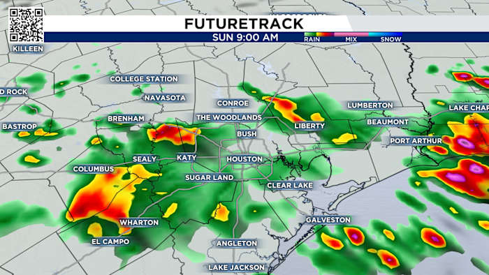
Noon: Watching and tracking rain and the chance for thunderstorms just south of I-10.
Futuretrack this afternoon (Copyright 2025 by KPRC Click2Houston – All rights reserved.)
4 pm: Spotty showers for the majority of the area.
Tracking widespread to isolated scattered showers (Copyright 2025 by KPRC Click2Houston – All rights reserved.)
6 pm: We’ll track light rain for areas to the north near I-45.
tracking light rain for areas to the north (Copyright 2025 by KPRC Click2Houston – All rights reserved.)
Watch for heavy downpours that could lead to ponding and lightning when storms pass. Especially in areas north where more than 3 inches of rain fell Saturday night.
Check out storm reports here: Check out where the heaviest rain fell in Houston, some storms dropping nearly 4″ or rain and counting!
Next cold front that moves through is Wednesday:
If you are hoping for lower temperatures, you get your wish Wednesday. This cold front will move through Houston. It will also bring a line of strong thunderstorms, possibly severe. After we get through this weekend, we’ll give you more details on timing and threats.
This front lowers temperatures for the rest of the week (Copyright 2026 by KPRC Click2Houston – All rights reserved.)Your Extended Forecast:
Monday and Tuesday’s rain chances are small. After Wednesday temperatures lower to the 70s with a couple of mornings in the 50s. Be safe this weekend.
10 Day Forecast (Copyright 2025 by KPRC Click2Houston – All rights reserved.)
Copyright 2026 by KPRC Click2Houston – All rights reserved.