
LUBBOCK, Texas (KCBD) – Strong winds will return tomorrow, with some of the strongest winds of the week expected.
Tuesday’s Wind
A 66 mph wind gust was measured at the Lubbock Airport early Tuesday evening. The strong wind was a result of widespread wind event driven by a low pressure area centered over southeastern Colorado, and the cooling effect of evaporating rain showers (virga) contributing to the downward speed of the wind.
Evening Storms
The storm threat this evening has ended for the KCBD/FOX34 viewing area. Storms, some severe, will continue east of the area. Those storms may produce damaging wind gusts greater than 70 mph and hail as large as baseballs. These storms are most likely in the orange highlight on the map below.
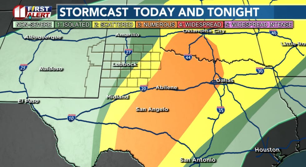 The threat of severe storms shifts east of the KCBD/FOX34 viewing area this Tuesday evening.(KCBD First Alert)
As severe weather season nears, we have a reminder for you. If you hear thunder, lightning is occurring near enough to strike your location. When thunder roars, go indoors. Even if indoors is a vehicle.
The remainder of the evening will be clear and breezy. The wind will gradually diminish overnight to about 10 to 20 mph.
 Chillier tonight with winds gradually diminishing to less than 20 mph.(KCBD First Alert)
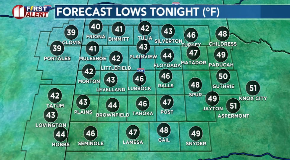
Lows will range from right around 40 degrees in the northwestern KCBD/FOX34 area to right around 50 degrees in the southeast.
Windy Wednesday
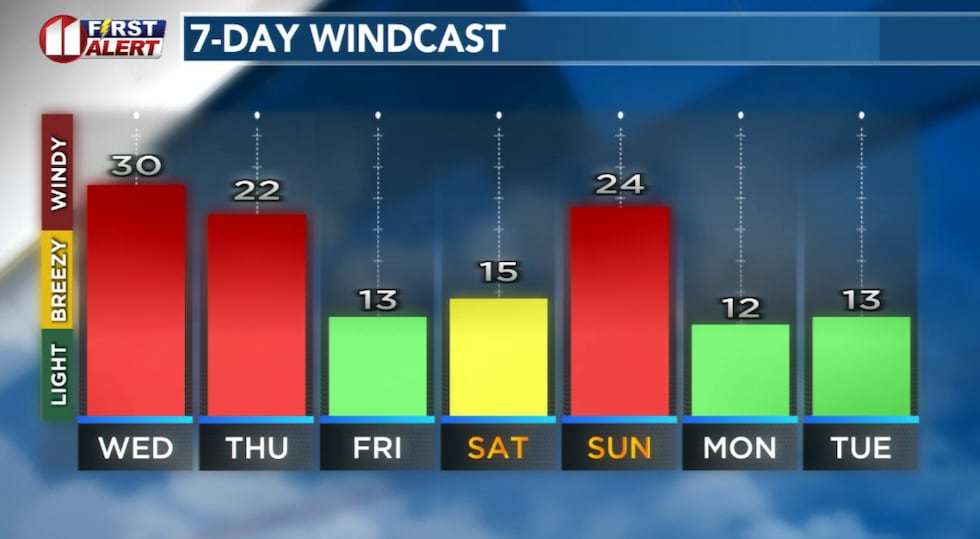
A Wind Advisory has already been issued by the National Weather Service for 9 AM to 7 PM CDT tomorrow. Wednesday will be the windiest of the week. That’s correct, even windier than today for much of the viewing area.
 Forecast peak sustained winds are shown in this graph. Peak gusts will exceed the values shown here.(KCBD First Alert)
The wind may impact your commute and outdoor plans.
Expect a sunny but dusty sky and very windy conditions throughout the day. North winds of 25 to 35 mph, with some gusts around 50 mph, are likely. At times, the sustained wind and gusts may even be stronger.
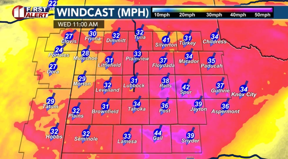 Wednesday is likely to be as windy, if not windier, than Tuesday.(KCBD First Alert)
Strong enough to make driving difficult, especially for high-profile vehicles like trucks and SUVs on east-west roadways, where the northerly wind will broadside your vehicle. In particular, in open areas outside the city.
Much Cooler
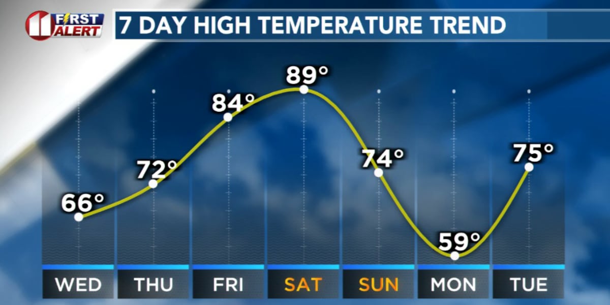
Temperatures will be much cooler, topping out in the 60s.
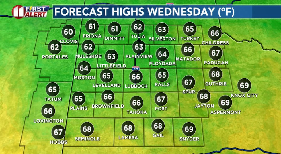 Much cooler and windy tomorrow. Low visibility in blowing dust likely.(KCBD First Alert)
The combination of strong winds and cooler air means it’s a good day to keep outdoor plans flexible. And of course, Wednesday is a NO BURN DAY.
After Wednesday’s windy day clears, conditions improve significantly. Thursday brings sunny skies and highs near 70 degrees with lighter winds. The warming trend continues Friday and Saturday, with highs climbing into the 80s and near 90 degrees by Saturday.
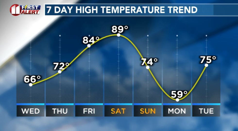 Much cooler tomorrow behind a cold front, then warming before another late in the weekend.(KCBD First Alert)
Saturday’s forecast high would be a record for the date. Lubbock’s current March 14 record high is 86°, on the date in 1972.
Another Cold Front
A cold front moves through late Sunday, bringing much cooler air and a mix of sun and clouds. Highs Monday will only reach the upper 50s before recovering back to the lower 70s by Tuesday.
 No rain is expected in the Lubbock area the next seven days.(KCBD First Alert)
On This Date
On this date in 1977, a significant region-wide wind and dust storm began on the morning of the 10th in the western Trans-Pecos before expanding northeast over the remainder of West Texas on the 11th. The storm finally subsided by the afternoon of the 12th. Low visibility, near zero at times, engulfed the region for many hours straight. In Ralls, two school buses collided with one minor injury. Fender benders and other minor auto accidents were common on the South Plains.
(Source: National Weather Service, Lubbock)
Copyright 2026 KCBD. All rights reserved.