
LUBBOCK, Texas (KCBD) – The strongest winds are behind us. As winds become light overnight under a clear sky, Lubbock-area temperatures will briefly dip to near freezing early Thursday morning. The cold won’t linger, however, as warmer afternoons – with a possible record high – are on the way.
Peak Gusts
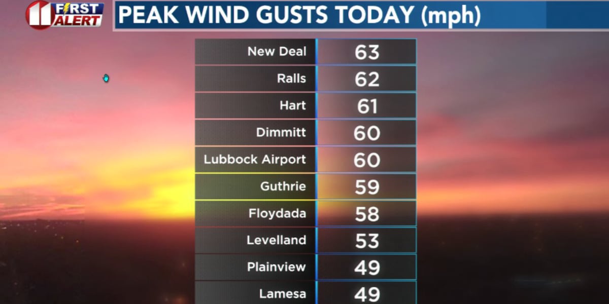
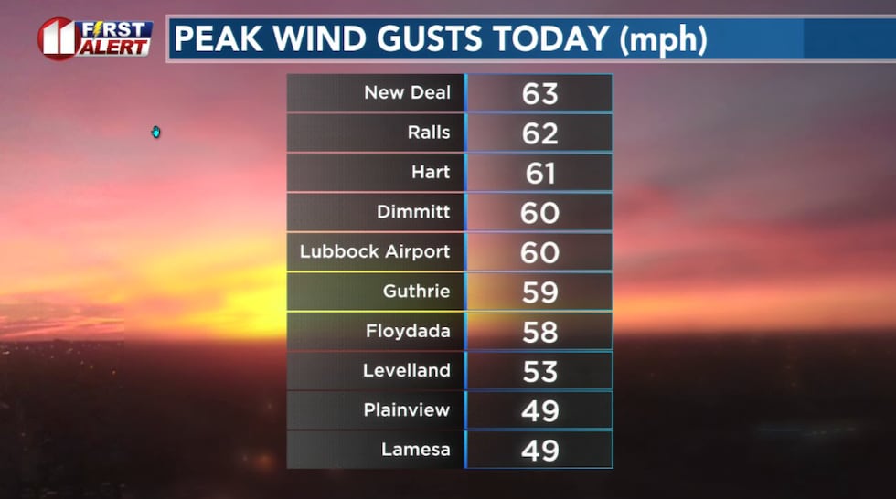
Today’s strong winds followed a strong cold front that moved south through the South Plains this morning. Peak wind gusts today ranged up to 61 mph. Even the Lubbock airport recorded a gust to 60 mph.
 Wind gusts of 40 to 50 mph were common across West Texas Wednesday. Some areas, however, recorded even stronger winds.(KCBD First Alert)
Gusts from around 40 to 50 mph were common across West Texas and eastern New Mexico.
Winds will continue to fade tonight, becoming light. The light wind and clear sky result in good radiational cooling. This will lead to one of our colder nights in quite some time.
A hard freeze is possible to the west and north of Lubbock early Thursday. If you have new vegetation that may be damaged by freezing temperatures you may want to take protective action this evening. At the very least, a good watering can help protect roots.
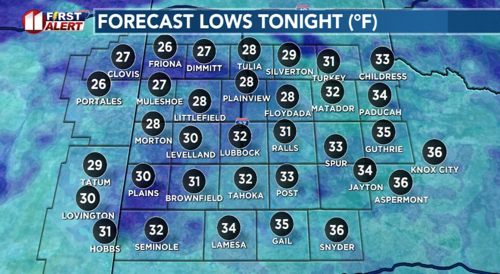 A freeze is expected over portions of the western and northern South Plains tonight.(KCBD First Alert)
A typical low this time of year for Lubbock is 37°. The record for the date, March 12, is 10° back in 1948.
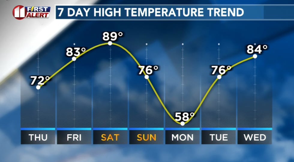
Temperature Turnaround
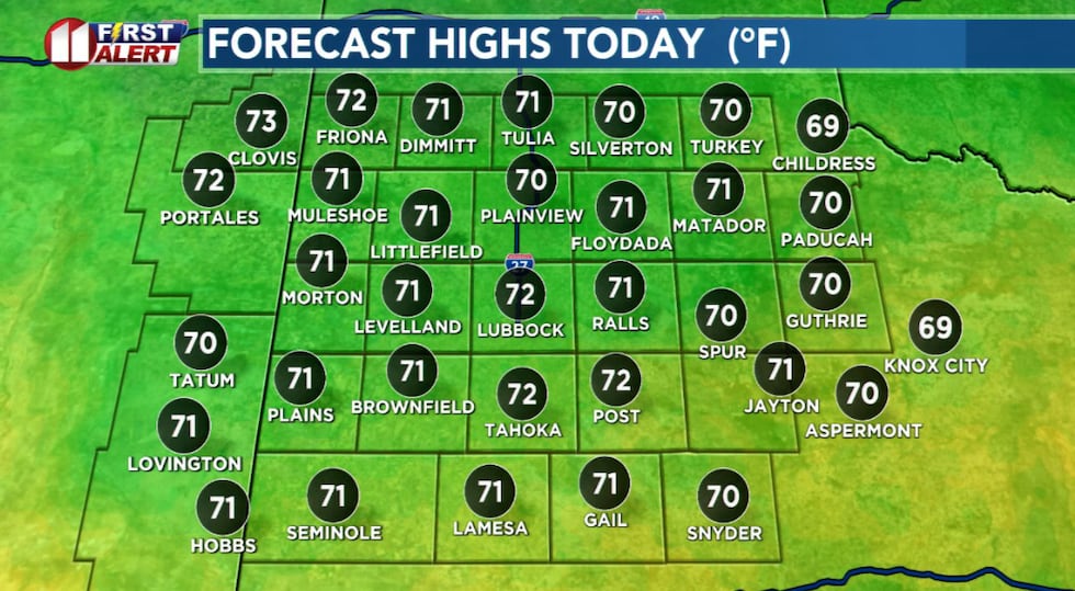
As noted, the cold will not last long. Temperatures will peak a little above average for mid-March Thursday, much above average Friday, with record highs likely Saturday.
 Warmer but again windy Thursday afternoon.(KCBD First Alert)
Days will be sunny and nights clear through Friday night, then partly cloudy Saturday afternoon into Sunday.
Lubbock’s record high for Saturday is 86°, recorded on the date (March 14) in 1972.
 Warming to a likely record high this weekend, before a significant but brief cool down early next week.(KCBD First Alert)
Then the next cold front moves in, currently expected late Sunday. Temperatures will again drop, with another freeze possible, behind the front.
The Winds
Thursday will be another windy day. There is, however, some good news. It won’t be as windy as the past two days. Still, some blowing dust is likely and it will be another NO BURN DAY due to an elevated grassland fire danger.
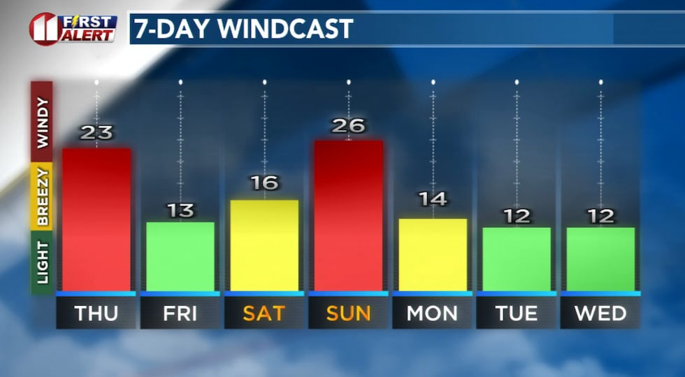 Forecast peak sustained winds are shown in this graph. Peak gusts will exceed the values shown here.(KCBD First Alert)
Strong winds are likely to accompany the next cold front, expected late Sunday. Another significant, but brief, drop in temperatures will follow the front. Lubbock again may experience freezing temperatures early Monday.
On This Date
On this date in 1990, a fast-moving line of strong thunderstorms caused sporadic wind damage across the South Plains early in the morning. The most substantial damage was to 15 vehicles that belonged to the city of Lubbock. Each had broken windows from wind-blown stones and other debris.
(Source: National Weather Service, Lubbock)
Copyright 2026 KCBD. All rights reserved.