
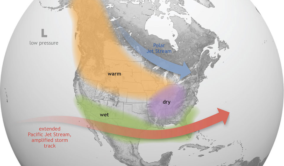
During El Niño, the Pacific jet stream stretches out and moves closer to Texas, resulting in more frequent cold fronts and a more active storm track across the southern United States.
Climate Prediction Center/National Oceanic and Atmospheric Administration
As of this week, La Niña is ending and Texas is on El Niño watch: But what does that really mean for Austin?
Let’s start by unpacking what exactly La Niña and El Niño are.
Article continues below this ad
What is La Niña and El Niño?
The warming and cooling of tropical waters in the eastern Pacific Ocean is a cyclical and naturally occurring phenomenon that involves shifts in trade winds and changes in sea-surface temperatures. Because this significant transfer of heat energy is happening in the world’s largest ocean, it can alter weather patterns around the world.
When the sea-surface temperatures in the eastern Pacific along the equator become warmer than normal, that’s called El Niño, and when they become cooler than normal, La Niña is in effect. When water temperatures are at their long-term average, that is called neutral phase.
“A transition from La Niña to (neutral) is expected in the next month,” according to the National Weather Service’s Climate Prediction Center on Thursday. Neutral phase has a 55% chance of lasting though spring and into July.
Article continues below this ad
But El Niño could emerge as early as this summer.
“In June-August 2026, El Niño is likely to emerge (62% chance) and persist through at least the end of 2026,” the Climate Prediction Center said.
The cooling of the equatorial waters of the eastern Pacific Ocean during La Niña, or the warming of the waters during El Niño, can affect atmospheric moisture. As a result it can cause shifts in the jet stream that could bring intense rainfall to some regions or drought to others.
National Oceanic and Atmospheric Administration/NASA
What does El Niño mean for Texas?
El Niño typically tends to mean wetter and cooler weather for Texas in the fall and winter. Both La Niña and El Niño can alter the path of the jet stream, a river of air that not only drives weather patterns from west to east, but also acts as a natural barrier between cooler polar air up north and warmer tropical air to the south.
Article continues below this ad
During El Niño, the jet stream can dip farther south and allow more storms and cold air to surge into Texas, which is how places like Austin can see more rainfall and less extreme heat during those times.
In fact, El Niño helped make 2015 the second-wettest year on record in Austin. That year included the deadly Memorial Day flooding in Central Texas and the October flooding that washed out Austin’s Onion Creek neighborhood. With 59.96 inches measured at Camp Mabry, Austin’s main weather observation site, 2015 fell just short of the 64.68 inches that fell in 1919.
On the other hand, La Niña, which was in effect during this past particularly dry and warm winter, can lead to rainfall deficits and record-high temperatures.
For a drought-stricken state like Texas and a rain-starved city like Austin, even the arrival of neutral conditions, as well as El Niño, could be welcome news.
Article continues below this ad
Drought data released Thursday from the U.S. Drought Monitor, a joint effort of the National Drought Mitigation Center, the U.S. Agriculture Department and the National Oceanic and Atmospheric Administration, indicate that drought across Texas has decreased only slightly. However, about 82% of the state is experiencing moderate to exceptional drought.
If Texas experiences just neutral conditions, without La Niña or El Niño, we could experience more seasonably average temperatures and rainfall. With much of Travis County in extreme drought, the U.S. Drought Monitor’s second-highest level of drought, and Austin rainfall about 2.4 inches below normal for the year to date, even climate-average rainfall amounts in April (2.42 inches), May (5.04 inches) and June (3.68 inches) can sound like a nice forecast.