
The past several weeks have brought remarkably warm weather to Southeast Texas – far warmer than it should be for this time of the year.
Last month, Houston recorded its second-warmest February of all-time, and the unusually warm weather has continued into March. Through the first two weeks of the month, Houston’s average high temperature has been 81 degrees – the city’s warmest start to March in more than 100 years.
However, don’t pack away the winter coats just yet. A strong cold front is expected to crash through Southeast Texas Sunday evening, bringing intense winds, rapidly falling temperatures, and even a chance of thunderstorms. Here’s an overview of what you can expect.
Sunday’s forecast
Before the cold front arrives, expect a warm and relatively quiet day across Southeast Texas. Mild and muggy weather is likely to persist through the morning, as temperatures hover in the mid-60s under mostly cloudy skies.
The elevated humidity levels could lead to patchy fog developing over parts of Southeast Texas, if winds are light enough, according to the National Weather Service.
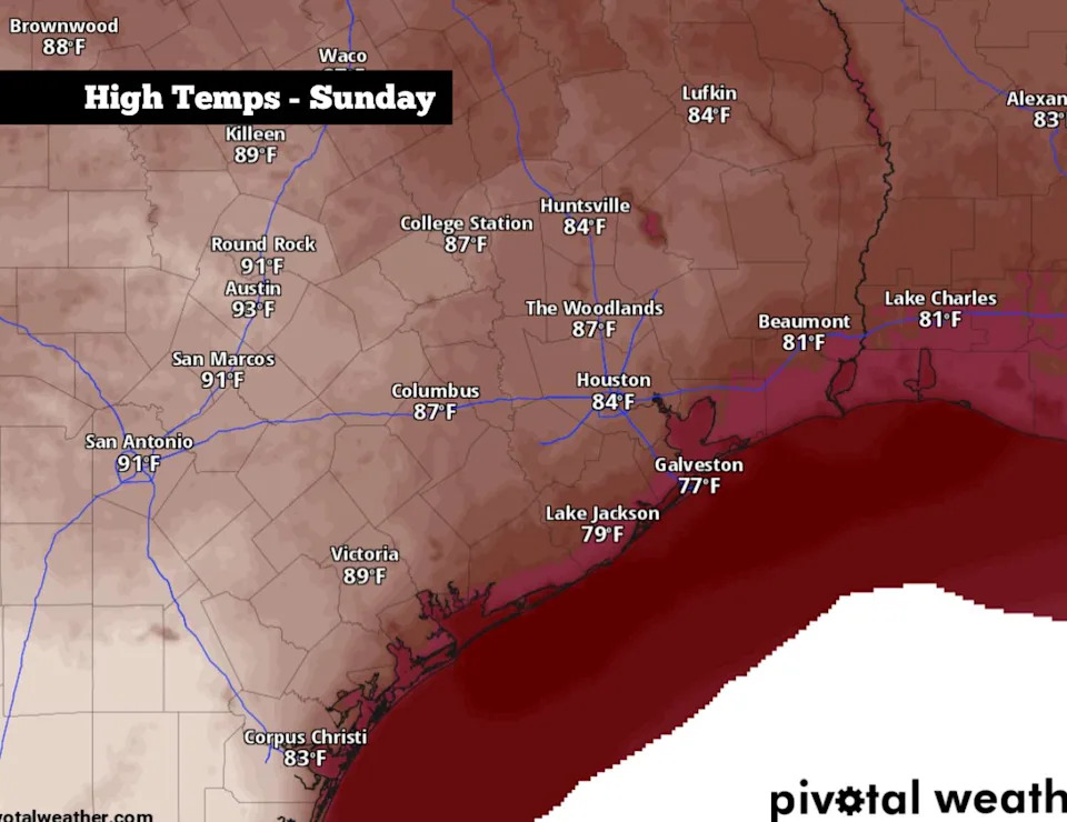
Shown are the expected peak afternoon temperatures across Southeast Texas on Sunday, before a cold front moves through the state. (Pivotal Weather)
Houston temperatures will rise steadily throughout the day, reaching the upper 70s by noon, before topping out in the middle to upper 80s in the afternoon – which would be about 10 degrees above average for mid-March. Winds will already be breezy throughout the day, moving in from the south at 15 to 20 mph.
“For those wanting to visit the beaches, make sure to verify the marine and beach flag conditions, given that winds and seas will be building and strong rip currents may develop,” the weather service warned on Saturday.
Cold front arrives
The cold front, which will push through North Texas by Sunday afternoon, will quickly dive south and arrive in the Houston metro area between 7 and 9 p.m.
For most of the state, the front will move though dry. However, the higher atmospheric moisture levels in Southeast Texas could result in a thin line of thunderstorms developing along the front as it moves through the region. Houston’s overall rain chances are about 30% to 50%, higher for those near and east of the Interstate 45 corridor, so not everyone will see rainfall.
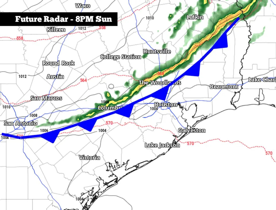
A thin line of storms could develop along a cold front surging into Texas on Sunday. It is expected to move through Southeast Texas between 7 p.m. and 9 p.m. (Pivotal Weather)
Because the front is moving fast – the weather service said it could go from the Brazos Valley to the coast in about 5 to 6 hours – any storms will move through very quickly, and rain is not expected to last any longer than 30 minutes. However, it should be noted that a few storms could be strong to severe, capable of damaging winds and hail.
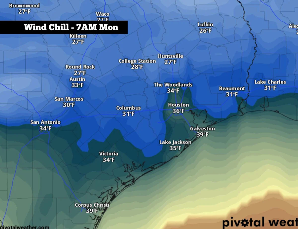
While storms are not a sure thing, plummeting temperatures are guaranteed. After the front moves through, Houston temperatures will drop quickly into the 50s by midnight. And by Monday morning, lows are expected to settle into the low to mid-40s – a 40-degree drop from Sunday’s high temperatures.
Winds will also be quite strong, leading to wind chill values falling into the 30s. Houston can expect sustained winds at 15 to 25 mph throughout the night, with periodic gusts as strong as 40 mph possible.
Monday’s forecast
Following the cold start on Monday, temperatures will stay below average throughout the day. Houston temps will hover in the 40s through the morning, likely rising into the mid- to upper 50s by the afternoon. Winds will also stay breezy, coming in at around 15 mph through the afternoon.
The coldest temperatures of the week are likely coming overnight Monday into Tuesday, as predawn temperatures are likely to fall to between 40 and 42 degrees in Houston. Areas to the north will be even colder, with morning temps likely in the upper 30s in Huntsville, College Station, and Conroe.
A steady warming trend is expected across Southeast Texas as we push into the rest of the week. Afternoon temps are likely to reach the mid-60s on Tuesday, followed by the mid-70s by Wednesday. Finally, temps in the 80s will make a return by Thursday and Friday.
This article originally published at Cold front Sunday night brings back winter chill to Houston. How low will temperatures go?.