
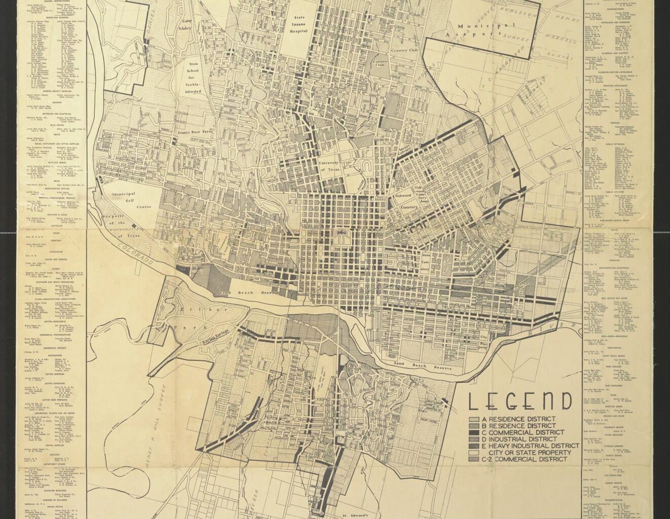
This 1939 Austin street map, issued by the Chamber of Commerce, helps define the land limits of the city before the post-World War II boom.
University of Texas at Arlington / Portal to Texas History
On Oct. 12, 2025, the San Francisco Chronicle, one of our siblings in the Hearst Newspapers family, published a fascinating article on the city’s 554 major streets.
Among the findings: About 40 percent of them were named after people, most of them men. Many others reflect famous or half-forgotten aspects of the city’s history.
Article continues below this ad
This wasn’t the first time that the Chronicle, founded in 1865, analyzed the streets of San Francisco.
On Feb. 5, 2021, the Chronicle examined the streets that were named after people who were morally suspect or worse.
Not sure we want to go there.
Could their October 2025 study, however, be duplicated in Austin?
Article continues below this ad
In terms of land size, San Francisco is much smaller. Despite its profound historical significance and its role as anchor for a population of 4.6 million people in its metro area, the city is compact at 47 square miles within its political borders.
Austin, on the other hand, weighing in with a smaller metro population of just 2.5 million, covers a land area of more than 300 square miles, or six times the size of Baghdad by the Bay. Not counting suburbs.
Austin contains within its political boundaries many thousands of distinct street names.
Article continues below this ad
What if, instead, we stayed inside the borders of historical Austin? Say those streets listed on a pre-World War II map of the city? That would represent something closer to the square miles of today’s San Francisco, which stopped growing in land size during the mid-20th century.
The 1939 Roster Austin Chamber of Commerce map is a good place to start. It stretches from Koenig Lane in the north to St. Edward’s University in the south; from Lake Austin in the west to Springdale Road in the east.
Helpfully — you’ll see why soon — that map includes the old Municipal Airport, now home to the Mueller neighborhood, with its rich cache of historical street names.
This column has already followed a few trails about Austin’s street names. We’ll revive those columns to form the basis for exploring what’s inside the boundaries of the 1939 map in the future.
Article continues below this ad
The following includes excerpts from a Sept. 3, 2024 “From the Archives” column. At least part of all these streets are on the Chamber of Commerce map.
Start at the very beginning
In 1839, at the direction of Texas President Mirabeau B. Lamar, frontiersman and planter Edwin Waller carved Austin out of the wilderness below the “Colorado Mountains” to the west. Master surveyor L.J. Pilie, who also worked on the plan for New Orleans, laid out a mile-square grid that remains the basis for our central business district. Another surveyor, William H. Sandusky, expanded on Pilie’s work by adding a garden district to the east.
The north-south streets were named after major Texas rivers. These roads were arranged — east to west — roughly in the order that these waterways appear on a map, from the Sabine River to the Rio Grande. They have remained mostly unchanged since the city’s birth. As Austin grew, however, additional streets were named after minor Texas streams, creeks and tributaries.
Article continues below this ad
Two north-south exceptions in the original grid: East and West avenues, which formed two boundaries of the walkable square-mile city. Today, West Avenue survives, while most of East Avenue, once one of the city’s most graceful boulevards, lies under the Great Wall of Interstate 35.
In 1839, the east-west streets were named for trees. This was a common practice in 19th-century American cities. Perhaps the names such as Pecan, Hickory and Live Oak were meant to take the place of the real trees that builders leveled during the 1830s. Shockingly, living trees were not planted along most downtown streets in a systematic way until the 1970s.
City leaders replaced the tree names with numbered streets on Sept. 21, 1886. Waller had actually preferred numbers for those east-west streets, as a July 11, 1839 letter to President Lamar proves. For a while, maps showed both their numerical and arboreal names.
Two more streets from the original grid deserve mention: Congress Avenue and Water Street. The first was named after the legislature of the Texas Republic, although the first capitol, a log structure tucked behind a defensive stockade, rose not on Congress but at West Eighth and Colorado streets. The second and fourth (the current one) capitol buildings, were placed on the hill originally designated as the grand processional way to Capitol Hill. (For a short while after the second capitol burned and the 1888 capitol was finished, a temporary capitol inside an office building stood on the southwestern corner of Congress and 11th Street. It was also home to the first University of Texas classes in 1883.)
Article continues below this ad
Water Street ran along the ridge of the bluff over the Colorado River where the village of Waterloo stood before Austin was founded. It became First Street, then Cesar Chavez Street. The Waterstreet Lofts on East Cesar Chavez preserve the name. Yet another street below Water, called ., survives only as an east-west street in East Austin.
Some major north-south arteries
Lamar Boulevard: Once part of the main road between Austin and Dallas, North Lamar was named for President Lamar. South Lamar was formerly called Oak Hill Road, Evergreen Road, Butler Road, State Highway 343 and the Old Fredericksburg Highway. Over the past decades, several Austin place names have been called into question because their namesakes were racists, enslavers or instigators of ethnic cleansing. Lamar was guilty on all three counts.
Guadalupe Street: Named for the Guadalupe River, itself named during the Alonso de León expedition in the 1680s as Nuestra Señora de Guadalupe to honor the Virgin Mary. When I came to town in 1984, many locals insisted on dropping the “e” at the end of the name. I’m hearing that less often these days.
Article continues below this ad
Burnet Road: The northwesterly road shares its name with the county northwest of Austin, which, according to Edward and Jean K. Callary’s magnificent book, “Texas Place Names,” was named for lawyer and politician David Gouverneur Burnet, president of the provisional government of the Texas Republic. Part of the road followed an old Indigenous trail to key passes in the Hill Country. (Added note: The president pronounced his name differently than do modern Texans when they refer to the road, county or town named after him.)
Mopac: Named for the Missouri-Pacific Railroad. The tracks in the middle of the freeway were originally laid out as the International-Great Northern Railroad. The Missouri-Pacific line merged with the Union Pacific Railroad in 1997. During the 1970s, the controversial Mopac project cut through some old neighborhoods, including the historic freedom colony of Clarksville, and was championed by Mayor Roy Butler.
Some major east-west arteries
Sixth Street: Once called Pecan Street, it is the sixth downtown street north of the Colorado River, at least as it crosses Congress. It once was the major road out of town to the east and rivaled Congress Avenue for commercial activity. While hospitality was part of its identity, it evolved into an entertainment district during the 1970s.
Article continues below this ad
Martin Luther King Jr. Boulevard: Formerly Magnolia Street and later 19th Street, it was named for the civil rights leader seven years after his death in 1968. The 1975 naming created quite a stir when business owners west of Interstate 35 did not approve of the change. A group called the West 19th Street Association fought the extension of the name past the Capitol complex and University of Texas campus to North Lamar Boulevard. They failed to make their case before an increasingly progressive City Council.
38th Street / 35th Street: This critical link between Mopac and Interstate 35 is an amalgam of two numbered streets, which can be confusing. Several streets in this area north of campus, such as 38th ½ Street bear a fraction in their names. Why? “I can’t find any document pointing to an answer,” Mike Miller, former city archivist, told the American-Statesman in 2018. “Nothing in old city codes. In looking at old maps and comparing to today, it looks like ½ numbers were used when a block or blocks bounded by numbered streets was resubdivided and a new street was made.”
U.S. 290-Koenig Lane-Allandale Road-RM 2222: This tangle of names is exactly what city planners were trying to avoid when they ruled that any new streets should adopt the names of earlier streets along the same path. According to the essential “Voices of the Violet Crown” website, Koenig was named for Dr. Joseph Samuel Koenig (1885-1951), a chiropodist, insurance executive and real estate developer: “Dr. Koenig and his wife, Lera Lynn, owned property in at least four subdivisions that would become Koenig Lane — Koenig Place, Koenig Terrace, Murray Place and Northfield.”
Bee Cave Road: Yes, this road appears by name on the edge of the 1939 map! The curvy route from Austin through the hills to the town of Bee Cave, formerly known as Bee Caves, causes some concern. “Do not believe every road sign you read,” wrote Statesman columnist Jane Greig in 2015. “Bee Cave Road. No ‘s’ despite what some maps and businesses have in the phone book. Some indented stone areas referred to as the bee caves are in the vicinity, but the street name is singular.”
Article continues below this ad
Soon, we’ll go back into the archives, as promised, to look at the streets in the Mueller neighborhood, formerly the Municipal Airport, as well as other street-name material. After that, we’ll chip away at the rest of the streets that lie now within the boundaries of the 1939 map.
That’s almost 50 names explained so far. Don’t know if we’ll hit 554 like San Francisco, but we’ll have fun along the way.
Please send tips and questions to mbarnes@statesman.com
Article continues below this ad