

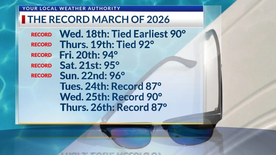
Few will forget the exceptional, record heat of March 2026. Sunday make our 5th record in a row with three more records coming this week. Today’s high was 96, which broke the record of 93 set in 2017. Here’s a summary of the records so far since Wednesday.
We FINALLY get a “cool” front, a brief interruption to our stretch of record days. Here’s your exclusive 9-Hour Forecast for Monday with your 9-Day Forecast below.

TONIGHT: The skies will be partly cloudy, and the winds will shift overnight as a “cool” front comes in. The winds will turn north and then NE at 10-35 mph. This will cause much stronger gusts on the west slopes of the mountains. The winds could also stir up a bit of a dusty haze in the night. The low will be 58.
FORECAST: Monday will start out with gusty morning winds with the “cool” front. The skies will be mostly sunny with a few clouds and cooler winds. With a high of 86, we will interrupt our stretch of record heat for March. The NE winds will turn SE in the afternoon and will range from 10-20 mph. Another big zone of high pressure builds up right over the Borderland. Tuesday will be sunny and 94. The SW winds will range from 10-20 mph. (Tuesday’s Record: 87 in 1988) Wednesday will become very, very hot with a high of 99 as high pressure reaches its maximum. (Wednesday’s Record: 90 in 2012) Thursday will be sunny and 98. (Thursday’s Record: 87 from 2025) On Friday, cooler gusts will usher in a cold front. Look for partly to mostly cloudy skies with a high of 76. The NE winds will range from 15-40 mph. Saturday will be partly to mostly cloudy with a high of 75.

Copyright 2026 Nexstar Media, Inc. All rights reserved. This material may not be published, broadcast, rewritten, or redistributed.
For the latest news, weather, sports, and streaming video, head to KTSM 9 News.