
Editor’s note: To view this story as it appeared in Community Impact’s March Lake Travis-Westlake print edition, click here.
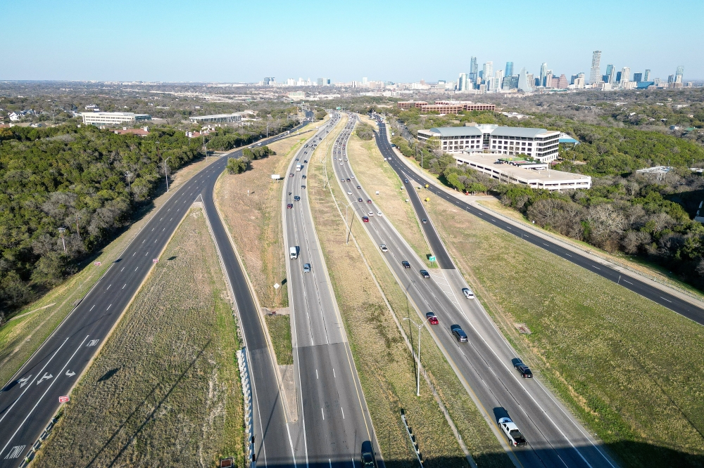
For over a decade, the Central Texas Regional Mobility Authority has spearheaded an $825 million project along 8.77 miles of MoPac South between Cesar Chavez Street and Slaughter Lane.
How we got here
Mobility Authority officials said MoPac South is consistently ranked among the most congested roadways in Texas. In 2013, the agency and the Texas Department of Transportation initiated an environmental study of the corridor to identify options to improve mobility and safety.
While the project has faced various delays in the years since, the Mobility Authority held six open houses before publishing the project’s draft environmental assessment Feb. 13.
“While there is much work to be done on gathering and responding to public comments, we look forward to fulfilling the community request for the Mobility Authority to sponsor this environmental study,” Mobility Authority Executive Director James Bass said.
The study utilizes the recommended build alternative 2C configuration that proposes building one to two express lanes in each direction between Cesar Chavez and Slaughter, despite some pushback from the community regarding its environmental and traffic impacts.
Five other configurations and a no-build alternative were studied, but the Mobility Authority said 2C reflects public feedback and is expected to reduce travel delays by 2045.

Breaking it down
The 2C configuration features northbound and southbound express lanes from Cesar Chavez to the Barton Skyway via an elevated, wishbone-shaped ramp, which Mobility Authority officials said will eliminate vehicle weaving and allow for multiple downtown exit options.
The configuration also includes two express lanes from Barton Skyway to Convict Hill Road, one express lane from Convict Hill Road to Slaughter Lane, and other improvements, such as a shared-use path connecting the Roberta Crenshaw Bridge over Lady Bird Lake to Slaughter Lane.
According to Mobility Authority documents, the agency has incorporated community input collected over the years into 2C’s design, including:
Adding a direct connection at US 290, a collector-distributor road from Barton Skyway to Loop 360, and a south-to-north U-turn at Barton SkywayLengthening the turn lane leading to the U-turn at Loop 360Adding more bike and pedestrian crossings on each side of the corridor, and widening or relocating shared-use pathsMobility Authority documents also state 2C considers emergency vehicle response times, noting current shoulder widths are too narrow for adequate response and could worsen as the region grows.
Put in perspective
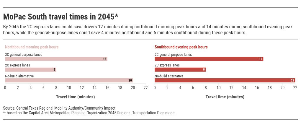
2C is also being evaluated against a no-build, or “do nothing” alternative.
According to the Mobility Authority, by 2045 the 2C express lanes would save drivers 12 minutes during northbound morning peak hours of 7-9 a.m. and 14 minutes during southbound evening peak hours of 4-6:30 p.m., compared to the no-build alternative. The general-purpose lanes would save drivers four minutes northbound and five minutes southbound.
Bobby Levinski, senior staff attorney with Save Our Springs Alliance, said construction generates a significant amount of traffic itself, and expanding road capacity only increases vehicle miles traveled.
“That’s the opposite direction I think a lot of people are trying to get the city to head, which is … trying to work towards traffic demand management solutions where we can have some alternatives to just highway expansion,” Levinski said. “I think a lot of people are asking, is it really worth it?”
The local impact
Some community members have raised concerns that the proposed plan could pose challenges for local businesses.
Cathy Hoover, CEO of the Westlake Chamber of Commerce, said the plan could impact traffic patterns for residents coming from the east and west parts of the corridor, making it increasingly difficult for businesses to attract and retain talent.
“Larger residential communities rely heavily on Bee Cave Road and Loop 360 for access to MoPac and downtown Austin,” Hoover said.
Paige Ellis, Austin City Council District 8 council member, also submitted a letter to the Mobility Authority last January that included a request for only one express lane to be built.
“There’s a lot of discussion around toll roads, particularly in southwest Austin, that are concerning to a lot of people,” Ellis said. “We certainly do not want to become a thoroughfare to bypass I-35.”
Stay tuned
The Mobility Authority’s virtual public hearing for the draft environmental assessment opened March 9 and will run through May 3. The agency also held an in-person public hearing March 24.
The agency worked with TxDOT and the Federal Highway Administration to consider a more in-depth environmental impact statement, which Levinski said is needed for a project of this scale.
“In all cases, TXDOT has consistently confirmed that an EA is the appropriate [National Environmental Policy Act] environmental study process for this project,” Mobility Authority officials said in an email.
According to the agency, once feedback is reviewed and considered for project adjustments, the final environmental assessment document will be submitted to TxDOT. If a finding of no significant impact is received, the Mobility Authority can then vote to move into the next phase of funding, design and construction.
Get involved
Community members can provide public comment on the draft environmental assessment through May 3 via the following:
Online at ph.mopacsouth.comBy mail to Central Texas Regional Mobility Authority, c/o MoPac South, 3300 N. IH-35, Suite 300, AustinIn a three-minute maximum voicemail at 512-387-5811