
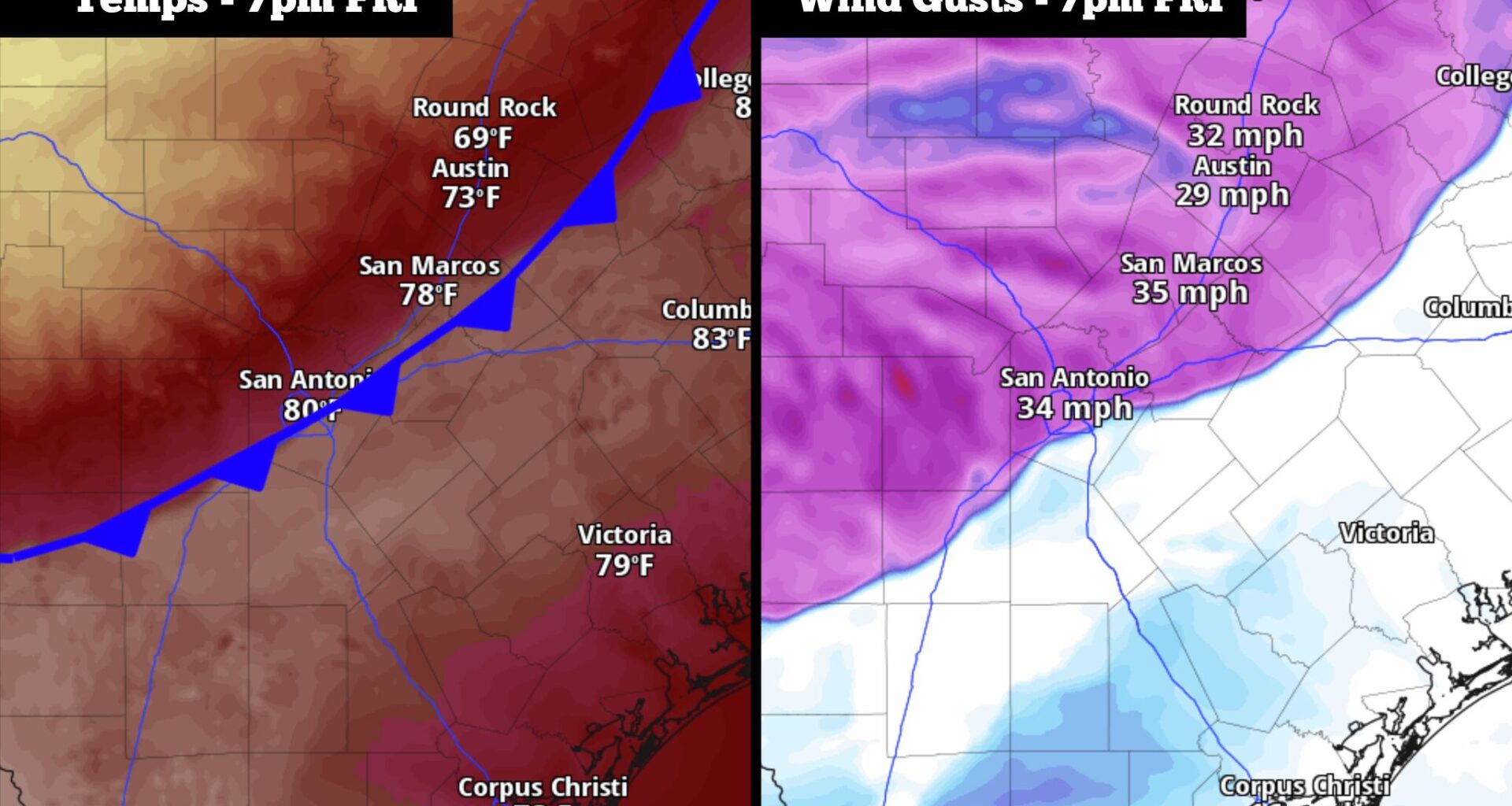
The cold front is expected to push through San Antonio by 6 to 7 p.m. Friday evening, dropping temperatures and bringing strong wind gusts.
Pivotal Weather
A cold front, which already moved through the Texas Panhandle overnight, will continue to surge south Friday into the rest of the state. This front is packing a punch, as parts of West Texas will see high temperatures in the 50s — that’s about 40 degrees colder than Thursday’s high temps.
As is often the case, the front will lose some of its strength by the time it reaches San Antonio. However, recent weather model data does show that the front might move in quicker and be a bit stronger than previously expected, bringing much cooler weather for Saturday. Here’s a breakdown of the current timeline.
Article continues below this ad
Friday’s timeline
Morning (5 to 11 a.m.): Friday will start similarly to the past several mornings across South Texas. Mostly cloudy skies are expected to develop across the region as temperatures hover in the mid-60s.
Skies will steadily clear up by late morning, resulting in warming temperatures in the mid-70s by 11 a.m. Also by this time, the incoming cold front will be moving into the far northwestern Hill Country, with the front edge still more than 100 miles from San Antonio.
Midday (11 a.m. to 4 p.m.): The cold front will continue to move through the Texas Hill Country, likely reaching Kerrville and Fredericksburg by 2 to 3 p.m.
Article continues below this ad
Shown are the expected high temperatures across South and Central Texas Friday afternoon.
Pivotal Weather
Meanwhile, San Antonio will see temps ramp up quickly under bright sunshine. The metro area will reach the lower 80s by 1 p.m., but then surge to the upper 80s to near 90 degrees by 4 p.m. If highs do hit 90 degrees, it would be the sixth time it’s happened this month and tie the most 90-degree days ever during March in San Antonio.
Evening (4 to 9 p.m.): The cold front is expected to arrive during this time, likely reaching downtown San Antonio by 6 to 7 p.m. Upon the front’s arrival, temperatures will likely drop by 15 degrees within an hour, and continue to fall into the 60s just after 8 p.m.
Article continues below this ad
The cold front will also bring strong winds from the north, sustained at around 20 mph through much of the evening. Periodic stronger gusts could reach 30 mph or higher. An isolated shower is not out of the question as the front arrives, but the majority of the region will stay dry.
Cooler overnight and Saturday
San Antonio temperatures will continue to fall steadily overnight, likely reaching the mid-50s by early Saturday. The Hill Country will be colder, with temps in the upper 40s from Kerrville to Fredericksburg. A few light showers or drizzle are possible as well.
Article continues below this ad
Northeast winds will continue throughout the day on Saturday, which will limit warming. San Antonio temperatures will likely hover in the upper 50s throughout the morning, eventually rising into the upper 60s to low 70s by the late afternoon — about 20 degrees cooler than Friday.
Saturday morning will likely feature mostly cloudy skies, but partly sunny skies are expected to return by the second half of the day. A cool evening in the 60s is expected, before falling back to the upper 50s overnight.
Warming back up
The cooler weather will be short-lived, as yet another warming trend is expected to close out the month. On Sunday, San Antonio temps will rise back into the mid-80s under mostly sunny skies. Then on Monday, expect highs in the upper 80s to near 90 degrees.
Article continues below this ad
Temperatures will stay consistent Tuesday and Wednesday, as temperatures rise into the upper 80s to lower 90s while morning lows warm back into the mid- to upper 60s. A slight chance of storms will enter the forecast by Wednesday evening and Thursday next week.