
San Antonio this year is experiencing one of its warmest months of March ever. To date, the city’s average high temp sits at 83.3 degrees, or about 10 degrees warmer than the climate-normal. The past week has been even warmer, with an average high of 90 degrees.
This weekend, South Texas is finally seeing some relief from the heat, courtesy of a cold front which swept through Friday evening. Behind the front, San Antonio will experience increased cloudiness and northeast winds throughout Saturday. As a result, we could see afternoon temperatures about 17 to 20 degrees cooler than Friday. More changes are coming next week, though. Here’s a look at what you can expect.
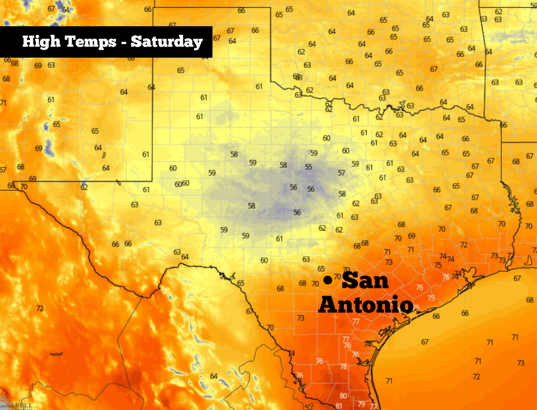
If you have any plans early Saturday, you may want to bring a jacket as temperatures will likely hover in the upper 50s to near 60 through 11 a.m. Winds will be breezy, too, coming in at around 15 mph some some gusts reaching more than 20 mph.
A few scattered showers and drizzle also will also be possible through the morning in some areas. However, rain chances in San Antonio will only be around 20%, and if you do see rain, it will stay very light. The Hill Country will have slightly higher rain chances, at around 30%.
By afternoon, some clearing is expected, which will allow temps to warm up steadily. San Antonio will likely be in the low to mid-60s at noon, reaching a high temperature near 70 degrees by the late afternoon. The Hill Country will be several degrees colder, with temps topping out between 63 and 66 degrees from Kerrville to Fredericksburg.
Saturday evening will be cool and comfortable. Temperatures will stay near 70 degrees through 6-7 p.m., falling back into the 60s by sunset. Overnight lows will fall back into the 50s.
The window for cooler weather will be remarkably brief, though. San Antonio, after starting Sunday in the 50s, will quickly warm back into the mid-80s by the afternoon, under mostly sunny skies. Temperatures will warm by several more degrees on Monday, reaching the upper 80s to near 90 degrees.
The warmest days of next week are expected Tuesday and Wednesday, as highs likely reach the low 90s and morning lows sit in the mid- to upper 60s.
The upper-level weather pattern is also expected to become more active, which could allow scattered thunderstorms to develop. San Antonio’s rain chances will only be around 20% Tuesday evening, but they’ll rise to 30% to 40% by Wednesday. A few storms could be strong to severe, so be sure to stay updated at expressnews.com/weather.
Weather models indicate that a weak cold front might move through the region by late Wednesday and into early Thursday. This likely won’t result in massive temperature changes, as afternoon highs would fall by only 5 degrees or so. Slight rain chances might also continue through the end of the week.