
FORECAST HIGHLIGHTS
FIRST ROUND OF STORMS LATE WEDNESDAY/EARLY THURSDAY: Broken line of storms, could impact San Antonio’s Thursday morning commute
EASTER FRONT: Times of rain, leading to a damp and cooler weekend
EASTER CAMPERS: Check back for updates to the forecast
FORECAST
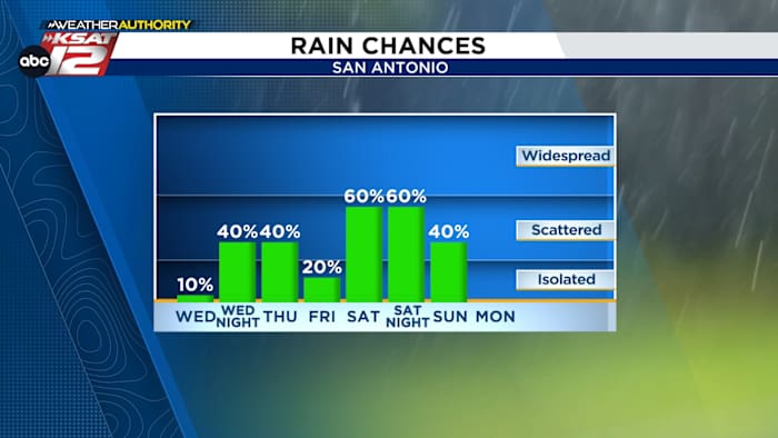
Things will continue to be warm and quiet until after sunset Wednesday. That’s when we’ll have our first opportunity for showers and storms. Here’s what you need to know:
WEDNESDAY NIGHT & THURSDAY MORNING STORMS
A broken line of showers and storms will push east out of West Texas Wednesday night. They’ll arrive to the Hill Country after sunset. As that happens, strong to severe storms are possible with quarter sized hail and gusty winds.
Tomorrow will be quiet and warm, but there’s a chance San Antonio will get glanced by storms Thursday morning (Copyright 2026 by KSAT – All rights reserved.)
As is often the case, the broken line of storms will weaken as it pushes toward San Antonio, arriving after midnight. Rainfall totals will be less than a half of an inch for most. All rain should push east of San Antonio by 10 am Thursday. IMPORTANT: The Thursday morning commute *could* be affected depending on how quickly the rain exits to the east. Plan now to deal with at least damp roads Thursday morning.
EASTER WEEKEND
Our next opportunity for much-needed rain comes at an inopportune time: Easter Weekend.
Easter weekend will feature times of rain. It’ll be warm Saturday, but much cooler Sunday (Copyright 2026 by KSAT – All rights reserved.)
The first half of Saturday will be warm, near-80°. But, a cold front will move toward South Texas Saturday afternoon. It will stir up showers and storms as it does. Saturday evening has the potential to be wet and windy, as the front passes by
In the wake of the front Saturday night, gusty winds, lingering rain, and cool temperatures will make for less-than-ideal camping conditions. Clouds will hold for most of Sunday, while light showers linger — potentially into the afternoon. While that’s not a guarantee, it’s best to have a back-up indoor option for any Easter egg hunts…just in case!
Regardless of how long rain sticks around, it’ll be much cooler Sunday! Highs will struggle to get out of the 60s. Plan those Easter outfits accordingly!
The latest forecast from Your Weather Authority (Copyright 2026 by KSAT – All rights reserved.)
RAINFALL POTENTIAL
At most, San Antonians will see up to an inch of rain COMBINED from Thursday morning and the weekend. It’s not much, but it’s something for our multi-year drought. The highest rain totals will be across North and Central Texas.
Most of the rain will fall in North and Central Texas, but San Antonio may see a total of up to an inch of rainfall. (Copyright 2026 by KSAT – All rights reserved.)Daily Forecast
KSAT meteorologists keep you on top of the ever-changing South Texas weather.
QUICK WEATHER LINKS
Copyright 2026 by KSAT – All rights reserved.