
Texas severe weather is ramping up as spring finally starts acting like spring.
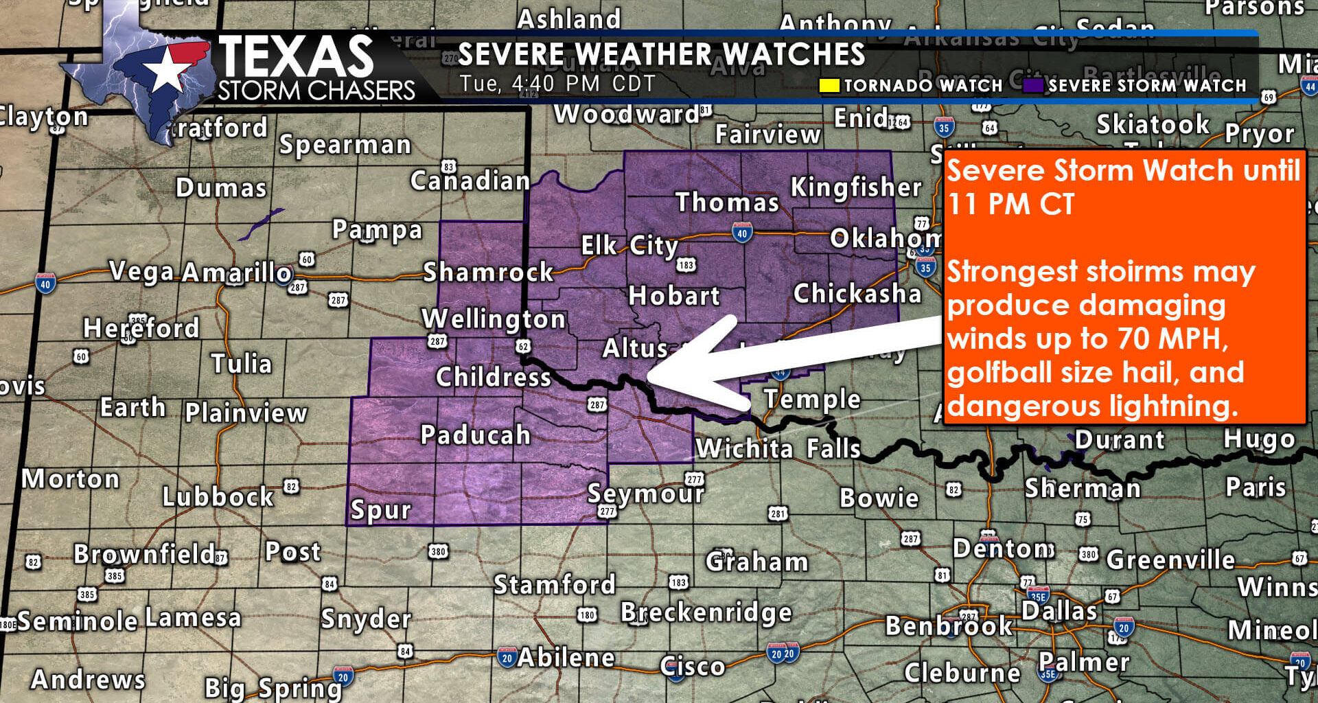
Storms are already developing across parts of Northwest Texas, the southeastern Texas Panhandle, and West Central Texas this evening. Some of the strongest storms may produce large hail, damaging wind gusts up to 70 mph, dangerous lightning, and blowing dust in the driest areas. A Severe Thunderstorm Watch remains in effect until 11 PM for parts of Northwest Texas and nearby areas.
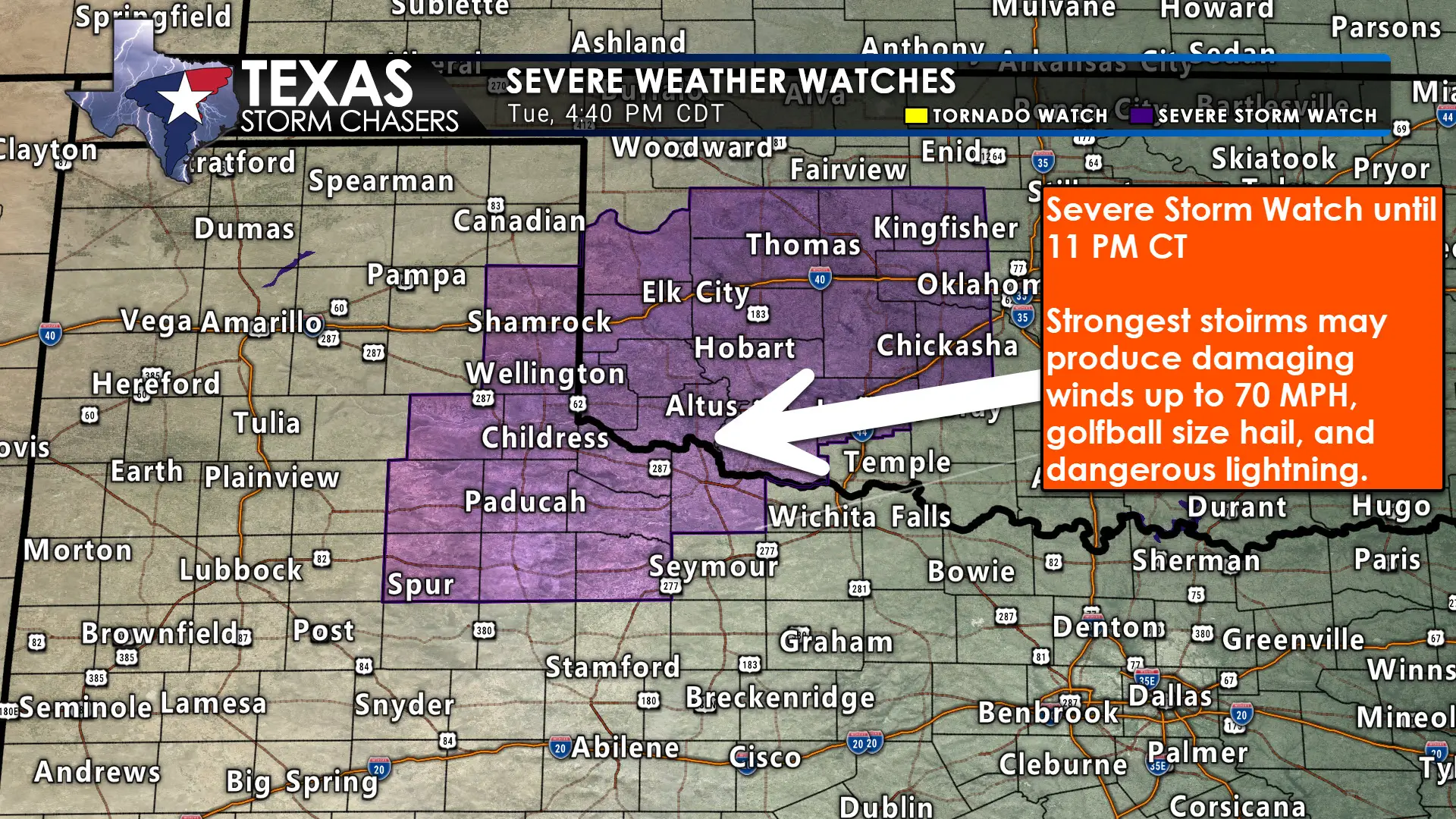
A Severe Thunderstorm Watch is in effect until 11 PM for parts of Northwest Texas, the southeastern Texas Panhandle, and West Central Texas.
The bigger concern arrives on Wednesday afternoon, Wednesday night, and into Thursday morning, when a more widespread round of storms is expected to develop across a large part of the state.
Main Severe Weather Threats
This setup still looks mainly like a hail and damaging wind event for Texas.
The tornado threat remains low, although an isolated tornado or two cannot be completely ruled out with any discrete storms Wednesday afternoon and evening, or along the leading edge of a line of storms Wednesday night. At this point, the more notable tornado threat appears to stay farther north into Oklahoma and southern Kansas rather than across most of Texas.
The primary threats across Texas will be:
Large hail
Damaging winds
Frequent lightning
Locally heavy rain
Areas Most at Risk
The highest severe weather risk is focused across Northwest Texas, where a Level 3 out of 5 risk has been introduced.
A broader severe weather risk also extends across parts of the Big Country, Concho Valley, western North Texas, North Texas, the Hill Country, and Central Texas as storms spread east and southeast with time.
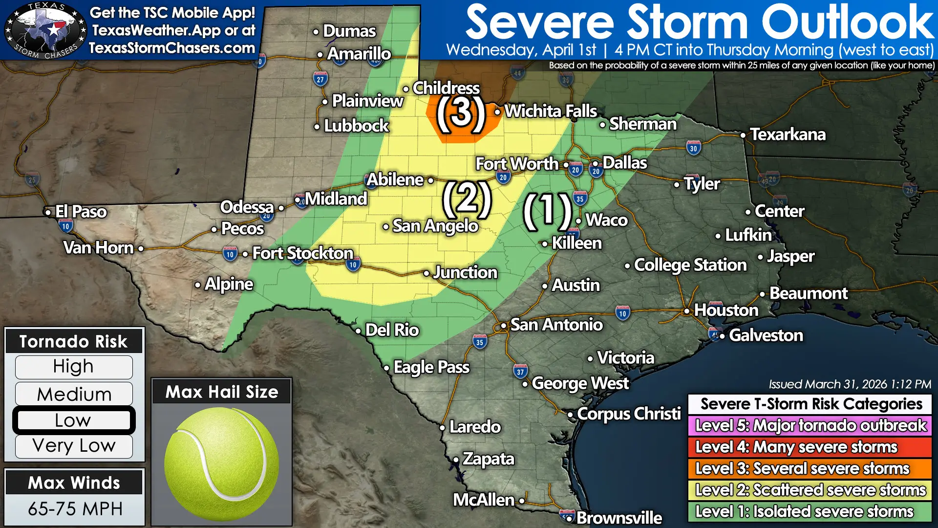
Severe weather outlook for Wednesday afternoon into Thursday morning across Texas, with the highest risk focused in Northwest Texas.
Storm Timing Across Texas
A few storms will continue this evening before activity settles down later tonight.
By Wednesday afternoon, generally after 3 to 4 PM, new storms are expected to develop across Northwest Texas, the Big Country, the Concho Valley, and western North Texas. Those storms should increase in coverage through the evening and then push east overnight.
As we move into Wednesday night and early Thursday morning, storms are expected to move into North Texas, Central Texas, the Hill Country, and possibly parts of South Central Texas. By Thursday morning, some storms may continue into the Brazos Valley, East Texas, the Coastal Plains, and possibly Southeast Texas.
Some storms could remain strong even after sunrise Thursday, especially if a line of storms is still producing strong winds. Hail will be most likely with more isolated storms Wednesday afternoon, but there is also some potential for renewed hail development late Wednesday night into early Thursday if additional storms form behind the main line.
Bottom Line
Texas is entering a more active stretch of spring weather, and this setup could lead to a long night across several parts of the state.
If you live in Northwest Texas, the Big Country, North Texas, Central Texas, or the Hill Country, now is the time to make sure you have multiple ways to receive warnings and stay weather aware tomorrow evening through Thursday morning.
We’ll be tracking storms live as they develop. You can watch the Texas Storm Chasers live stream on YouTube, follow along on the Texas Storm Chasers mobile app, or keep up with the latest forecast updates on our website and social media.