
We’ve got storms going on now in Texas, and we’re going to have a lot more weather to talk about Wednesday afternoon through Thursday morning. Current storms this evening include a severe storm near Guthrie with golf ball size hail and damaging winds over 70 mph possible, along with additional storms near Vernon that could still produce small hail and gusty winds. Activity should weaken later tonight, but the bigger setup is still ahead.
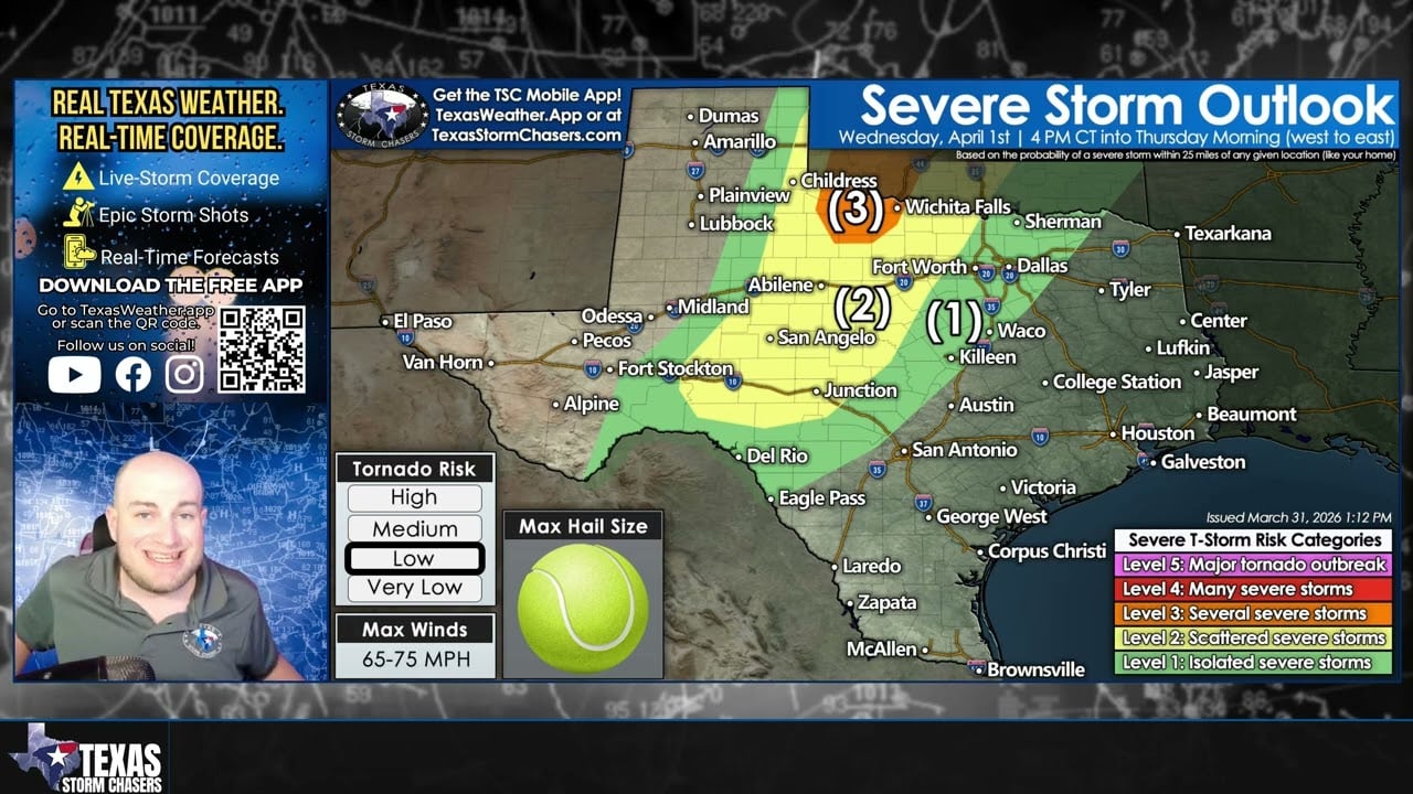
On Wednesday, we’re expecting scattered to several severe thunderstorms across the Concho Valley, Big Country, Northwest Texas, and nearby areas late in the afternoon into the evening. Some of those early, more isolated storms could produce:
• Very large hail up to tennis ball size
• Localized damaging winds
• A low tornado threat
Later Wednesday night into Thursday morning, storms should grow into a line and move east into:
• North Texas
• Central Texas
• Hill Country
• South Central Texas
• Eventually the Brazos Valley
As storms transition into more of a line, the main threat should become:
• Damaging straight-line winds of 60 to 70 mph, possibly 75 mph
• Hail
• Frequent lightning
• Heavy rain
• A brief spin-up tornado cannot be ruled out
Some storms may weaken as they move toward DFW and the I-35 corridor overnight, but stronger storms could hang on longer farther south across the Hill Country and parts of Central Texas into Thursday morning. There is also at least some chance storms could linger into Thursday afternoon farther east, though confidence in that is lower right now.
We’ll be live Wednesday evening into Thursday morning as storms move east across Texas.
Join this channel to get access to perks:
https://www.youtube.com/channel/UCoIfgmxArIATc2EpHD3W9EA/join
Download our FREE Weather App: https://texasweather.app/
Check out the links to our website & radar, live-saving tornado alert phone calls, photo gallery, donations/store, and other social media: https://www.Linktr.ee/texasstormchasers
#TexasWeather #SevereWeather #TexasStorms