
LUBBOCK, Texas (KCBD) – There is a lot of weather to cover today. From fog, to wind, to the first freeze of the season.
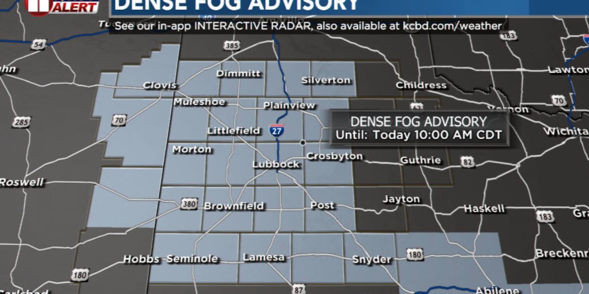
Most of our regional airports have at times reported low visibility in dense fog this morning. Areas of low visibility in fog, mist, and drizzle are possible through mid- to late morning on the Caprock. This includes the Lubbock and Plainview areas. The fog may persist through midday off the Caprock. This includes the Childress area.
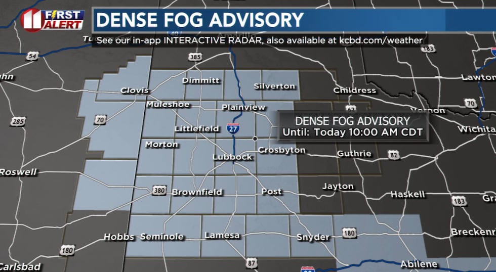 A DENSE FOG ADVISORY is in effect until 10 AM CDT today, Monday.(KCBD First Alert)
A DENSE FOG ADVISORY, issued by the National Weather Service, is scheduled to continue until 10 AM CDT (9AM MDT). Visibility of one-quarter mile or less in dense fog is possible across the South Plains, the Rolling Plains, and the southern Texas Panhandle.
Low visibility may make driving conditions hazardous. If driving, slow down, use your low-beam headlights (even during the day), and leave plenty of distance between vehicles. Allow extra travel time this morning and, as always, drive to conditions.
The fog is expected to dissipate from southwest to northeast across the Caprock late this morning. Low clouds may linger into the lunch hour in the Lubbock area. A quick warmup will follow as the clouds clear and sunshine returns.
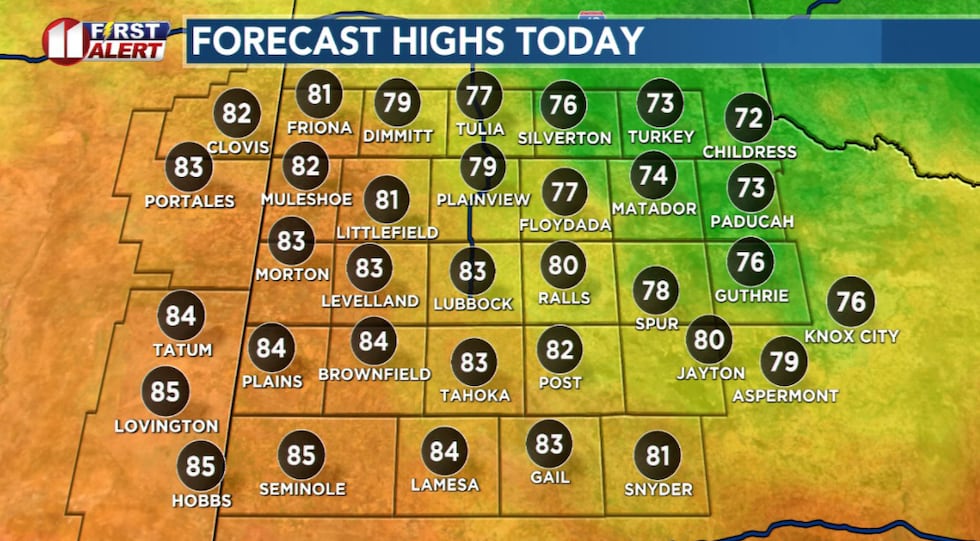 A wide range in high temperatures is expected this afternoon.(KCBD First Alert)
Low clouds may linger through the afternoon over the northeastern viewing area. This is likely to hold highs to the low to mid 70s in that area.
Before sunrise tomorrow, Tuesday, a strong cold front will move into the northern viewing area. It will quickly rush south across the entire area by mid-morning. There may be a few light rain showers, but the main weather will be a chilly wind.
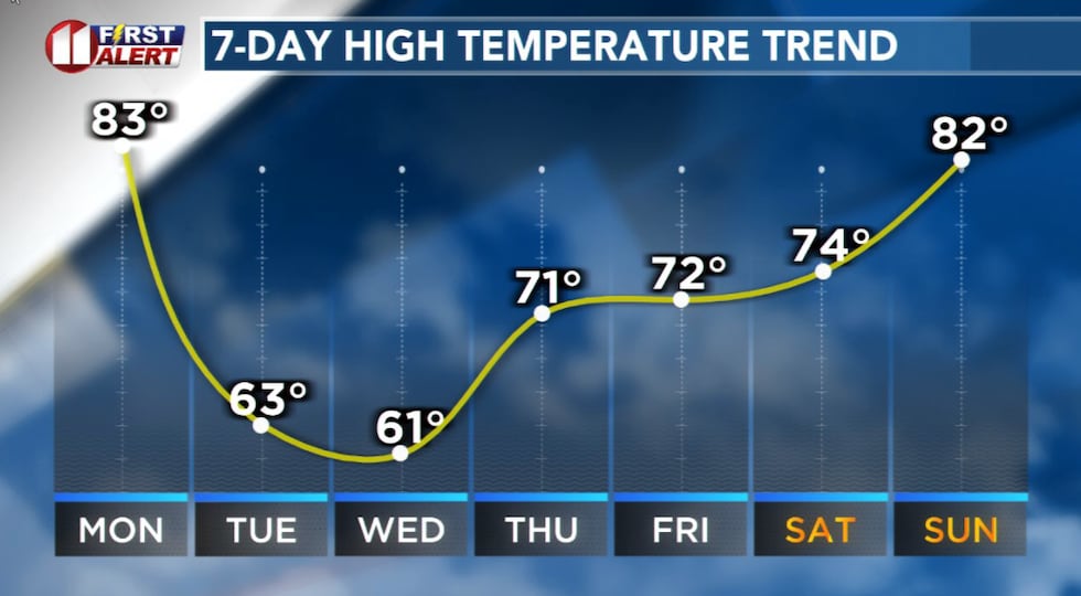 A strong cold front early Tuesday will be followed by much cooler afternoons Tuesday and Wednesday.(KCBD First Alert)
Behind the front the northerly wind is likely to be sustained from 20 to 30 mph with with gusts around 40 mph. The air itself will be much cooler, with highs Tuesday around 20 degrees cooler than today on the Caprock.
As the wind dies down under a clear sky, much of the northwestern viewing area will see its first freeze of the season early Wednesday. Currently, my forecast keeps the city of Lubbock above freezing Wednesday morning. However, Wednesday night into Thursday morning will be even colder. Even Lubbock may record its first freeze of Autumn.
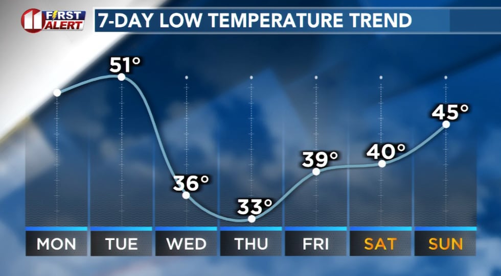 Lows in the 30s mid- to late week with a possible first freeze of the season for Lubbock Thursday morning.(KCBD First Alert)
Halloween weather is shaping up nicely. As of today I expect the day and evening to be dry with a light breeze. The morning will be chilly, the afternoon mild, the evening will get quite cool.
This weekend Daylight Saving Time ends. At 2 AM CDT Sunday, time FALLS BACK one hour to 1 AM CST. Both sunrise and sunset will appear to be an hour earlier than on Saturday.
 Lubbock received its First Freeze of the season this morning at 7:09 a.m.(KCBD Graphic)
Copyright 2025 KCBD. All rights reserved.