
The weather pattern across South Texas over the past few weeks has been stagnant to say the least. San Antonio recorded only 0.44 inch of rain during March and hadn’t recorded any rainfall over the past 20 days — a period that ties the longest stretch of dry weather in the city since last November.
That dry streak is likely to end soon, as San Antonio may have multiple chances for showers and thunderstorms over the next several days. The first chance will come early Thursday. Then, after a short break, even higher rain chances arrive over Easter weekend.
Before any rain chances come along, Wednesday will be another warm day across the region. Cloudy skies are expected early on, as morning temps are likely to hover in the upper 60s to near 70 degrees.
Wind speeds will turn quite gusty by the late afternoon, with some gusts as strong as 25-30 mph. Thunderstorms are expected to develop in West Texas, but San Antonio rain chances will stay low through the evening.
A cluster of showers and storms is expected to move into the Hill Country overnight and into early Thursday. Some storms could be strong to severe, with much of the Hill Country under a level 1 of 5 risk of isolated severe thunderstorms.
Some of this activity is expected to dip south into San Antonio Thursday morning, with the best chances coming between 6 a.m. and noon. However, this round of rainfall will be more of a glancing blow for San Antonio, with more widespread storms expected to stay farther north, from the Hill Country toward Austin. San Antonio rain chances, overall, will be around 40-50%.
A few isolated showers and storms might linger in the area Thursday afternoon and evening, but overall chances are expected to fall under 20%.
Higher rain chances are expected in San Antonio over the holiday weekend, courtesy of a strong cold front expected to surge through San Antonio by Saturday afternoon.
The timing of the cold front is still a bit uncertain, but it will likely bring a line of storms through South Texas sometime between 10 a.m. and 4 p.m. A few storms could be strong, but widespread severe weather is not anticipated at this time.
Behind the front, scattered showers could continue across the region from Saturday evening into parts of Sunday. The greatest risk of rain on Easter Sunday will come in the morning, with decreased rain chances expected by the afternoon and evening.
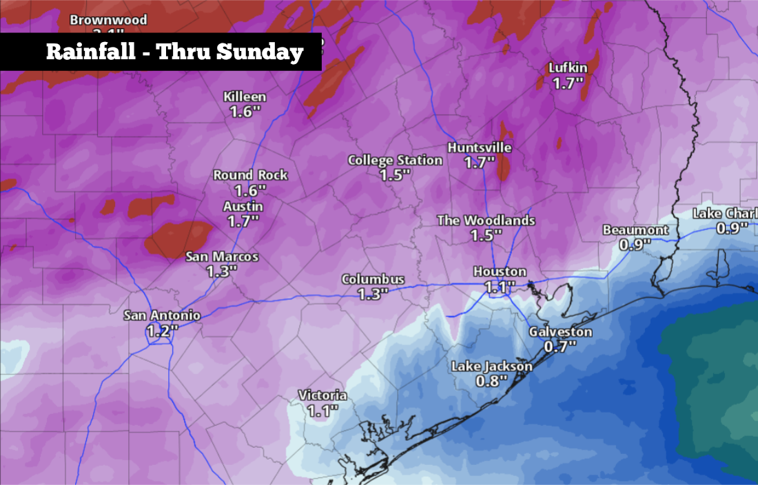
According to the National Blend of Models, rainfall totals between 0.75 inch and 1.5 inches is likely for the San Antonio area through Sunday. Higher rainfall totals are expected as you move to the north.
The cold front will also result in much cooler weather. On Easter, morning temperatures will start in the mid-50s, and they’ll likely only rise into the mid-60s by the afternoon — nearly 15 degrees below average for early April. Low temps will fall into the upper 40s to lower 50s by Sunday night.