
Saturday’s cold front will move through San Antonio by the early afternoon, bringing thunderstorms along with it.
Pivotal Weather
An especially active weather pattern is expected across South Texas in the next 48 hours, and it’s set to bring multiple rounds of rainfall to the San Antonio area. First, a cold front will slide through San Antonio by early Saturday afternoon, bringing potentially strong storms into the region, as well as colder temperatures and strong winds.
More rainfall is expected on Easter Sunday, which is likely to affect any outdoor plans for the holiday. How long will the wet weather last, and how much rain can be expected? Here’s what you can expect.
Article continues below this ad
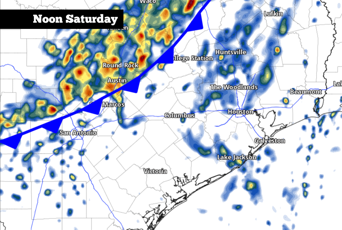
Saturday’s forecast
Relatively quiet weather is expected Saturday morning. A few isolated showers are possible, but most of South Texas will stay dry as temperatures hover in the lower 70s under mostly cloudy skies.
The cold front will dive through the Texas Hill Country during the mid- to late morning before arriving in the San Antonio metro area by the early afternoon, likely between noon and 2 p.m. As the front arrives, a broken line of showers and thunderstorms is expected to move into the region.
The National Weather Service’s Storm Prediction Center has issued a level 1 risk of isolated severe thunderstorms for parts of East Texas on Saturday.
Storm Prediction Center/Pivotal Weather
A few of the thunderstorms could be strong, capable of delivering small hail and gusty winds. An isolated storm could also produce larger hail, but the main severe threat is expected to stay east of San Antonio. The National Weather Service’s Storm Prediction Center has issued a level 1 of 5 risk of isolated severe thunderstorms across East and Southeast Texas, including areas around Victoria, Houston and Lufkin.
Article continues below this ad
By Saturday evening, rain chances will decrease, but the front will cause the weather to turn relatively chilly. San Antonio temperatures will likely be in the 60s by 4 p.m., before dropping into the 50s by sunset. Winds will also be strong, with some gusts reaching 25-30 mph.
Easter Sunday rain
Showers and weak storms are expected to move through South Texas on Easter Sunday.
Pivotal Weather
A weak system of low atmospheric pressure is expected to develop in northern Mexico by early Sunday, and this feature will allow rain to redevelop across the region, from the Rio Grande eastward to San Antonio.
Article continues below this ad
Scattered, off-and-on showers are likely for the San Antonio area on Easter morning, likely continuing into the middle of the day. Overall rain chances will be near 60%, so if you have any outdoor plans, such as Easter egg hunts, be sure to bring an umbrella along.
Bring a jacket, too, because temperatures will be well below average for early April. In San Antonio, morning temperatures are expected to hover in the 50s, only rising into the lower to mid-60s by Sunday afternoon. Winds will also stay breezy, coming in at around 15 mph throughout the day.
Shown are the potential cumulative rainfall totals across South Texas through Sunday.
Pivotal Weather
How much rain? Through Sunday, a half-inch to an inch of rainfall is likely in and around San Antonio, with isolated higher amounts possible. Heavier rainfall totals of an inch to 2 inches, are expected farther south, from Laredo eastward to Corpus Christi and the Rio Grande Valley.
Article continues below this ad
Temps stay cool
Cloudy skies and light, northerly winds are expected to persist into early next week, which will keep daytime temperatures in the upper 60s on Monday. An isolated shower is also impossible, but rain chances will drop to around 20%. Temps could rise slightly Tuesday, but they are still not expected to rise much higher than 70 degrees.
Temperatures will rise more substantially by the second half of the week. Expect daytime temps to peak in the mid- to upper 70s on Wednesday, likely pushing 80 degrees by Thursday.
Article continues below this ad