
LUBBOCK, Texas (KCBD) – Tuesday brings a chance of light rain, but our late-week into the weekend chance is looking much more significant. It’s worth paying attention to as the week unfolds. Here’s what’s coming our way.
Tonight
 Mostly cloudy and chilly Monday night.(KCBD First Alert)
Expect mild but chilly conditions tonight as clouds thicken over West Texas.
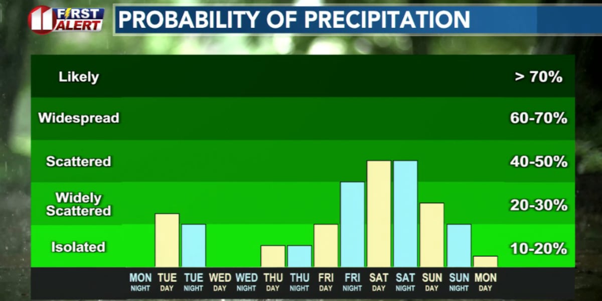
Light Rain Showers
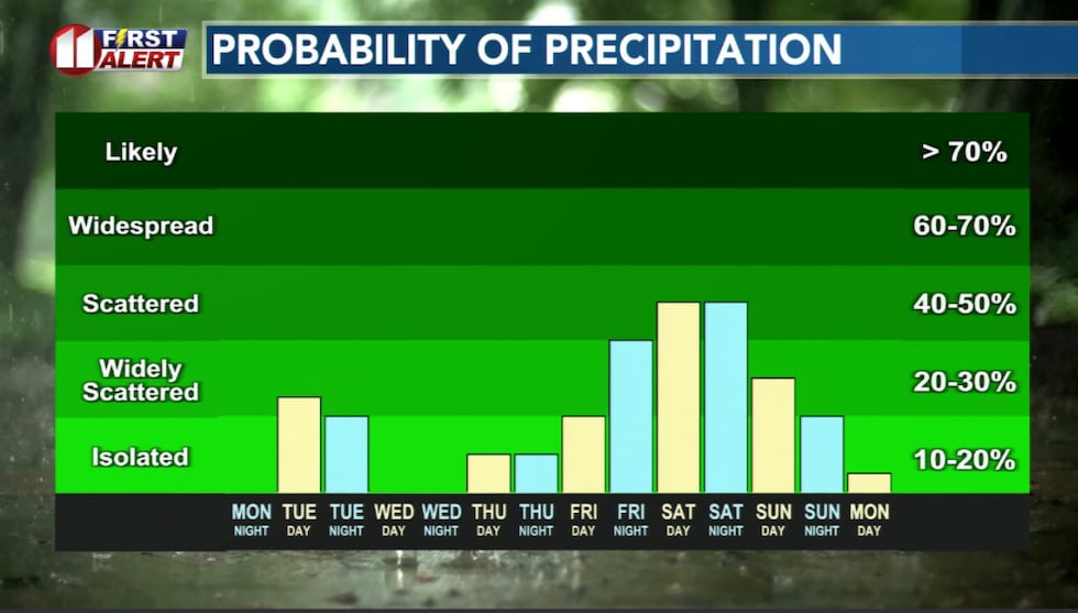
Tuesday a weak system will bring spotty light rain showers to portions of the area. This won’t be a washout. In fact, I expect many areas will remain dry. And where it does rain, most will be less than a tenth of an inch.
The greatest potential for measurable rainfall will be over the southwestern viewing area. A few isolated thundershowers are possible, again mainly over the southwestern viewing area, but severe weather is not expected.
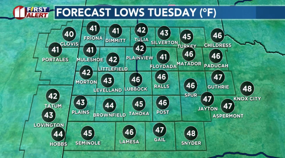
Temperatures will be cooler Tuesday due to the cloud cover and rain, with southerly winds picking up during the day.
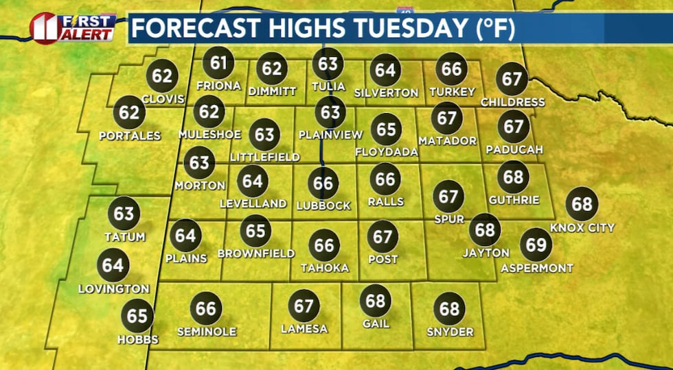 Spotty showers and a thicker cloud cover will hold temperatures to the 60s.(KCBD First Alert)
The rain will wrap up by Tuesday evening.
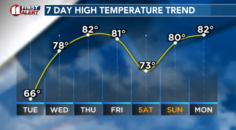
Warmer Afternoons
Wednesday will generally be sunny. After a chilly early morning, the afternoon will be much warmer. Once again, a southerly breeze of around 10 to 20 mph will pick up.
 Cool Tuesday, warmer late week.(KCBD First Alert)
Wednesday may be the best day for outdoor plans.
Storms Return
Late week weather may be quite active.
Starting Thursday evening and continuing through Friday evening, there will be a slight chance of rain showers and thunderstorms. These storms, if they develop, may produce damaging winds and large hail. At this time, and this may change, it appears overall coverage will be hit and miss.
 A slight chance of light rain Tuesday. Greater rain potential, and possibly severe storms, late this week.(KCBD First Alert)
Locally heavy rainfall is possible with any storms that do develop.
Stormy Weekend
With the approach of a stronger weather system Friday, storm and rain chances will increase heading into the weekend. Moisture will increase significantly, and the potential for multiple rounds of storms increases. If so, we may see heavy rainfall and localized flooding.
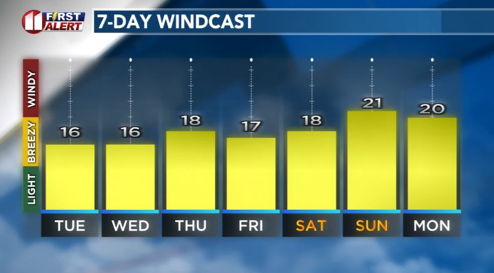 Forecast peak sustained winds are shown in this graph. Peak gusts will exceed the values shown here.(KCBD First Alert)
The main severe weather hazards are likely to be damaging wind gusts and large hail. Isolated tornadoes cannot be ruled out.
The main threat window, based on data available now, is Saturday and Saturday night. Given that West Texas is in a drought, heavy rainfall over a short period could lead to flash flooding, especially where storms train over the same areas.
Be Weather Aware
Keep an eye on our forecast this week, as there may be adjustments between now and the weekend. The timing and exact impacts could shift as we get closer, so stay tuned to First Alert Weather for the latest updates. Make sure you have a way to receive weather alerts on your phone, and don’t hesitate to take shelter if severe weather approaches.
 KCBD Rain Gauge Grand Prize(KCBD)
Copyright 2026 KCBD. All rights reserved.