
Future weather radar shows how Southeast Texas could look early Friday afternoon. Daytime heating will result in scattered to numerous downpours across the region.
Pivotal Weather
Storm chances will ramp up across Houston to end the work week, with Friday bringing the most widespread rain as a broader severe weather pattern begins to take shape across Texas.
HURRICANE SEASON: 2026’s first authoritative hurricane season forecast is out. Here’s what it means for Texas.
A storm system moving through the state will help trigger more widespread showers and thunderstorms Friday, especially during the afternoon. Scattered storms will linger into the weekend, and the evolving spring setup could bring a risk of stronger storms closer to Southeast Texas early next week.
Article continues below this ad
Houston storm chances peak Friday
Houston’s work week ends with the potential for numerous showers and thunderstorms.
Morning storms will most likely be between Interstate 10 and the coast before activity becomes more scattered and widespread during the afternoon. As temperatures climb to near 80 degrees, daytime heating will help fuel more storms — a typical spring setup that allows clouds to grow into showers and thunderstorms.
Not everyone will see rain, but more of the metro area will be affected than earlier in the week. Severe weather isn’t expected, though a few storms could bring brief gusty winds and heavy downpours that may slow the afternoon or evening commute. Activity should fade after sunset.
Article continues below this ad
Weekend outlook: Spotty storms
Storm chances linger into the weekend but Saturday could be the drier than Sunday. Because the influence of a weak ridge of high atmospheric pressure will remain, the highest chance of rain will be west of the Brazos River. Expect partly cloudy skies with highs near 80 degrees and only a slight chance for a stray shower or storm, especially south and west of Houston.
CLIMATE PATTERN: Super El Niño risk rises for 2026, new forecast shows. Here’s what it means for Texas
By Sunday, the weather becomes a bit more unsettled. Scattered showers and thunderstorms will be possible, popping up first during the afternoon and lasting through the early evening. While Sunday could see a few more storms than Saturday, the showers should remain hit-or-miss.
Article continues below this ad
Any downpour that moves over your neighborhood could produce heavy rainfall and briefly gusty winds. However, severe weather and flooding do not look likely across Southeast Texas.
Daily severe storm risk across Texas
A more active spring weather pattern is expected to take shape across the southern Plains beginning this weekend, possibly lasting into early next week.
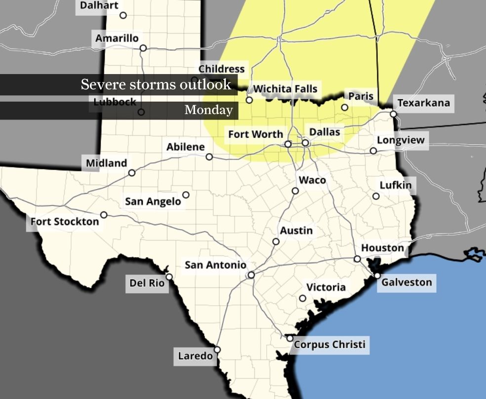
Storms developing across West Texas and the Panhandle on Saturday could strengthen as they move east, triggering risks for large hail and damaging winds. By Sunday and Monday, the risk of severe storms shifts to cities along the Interstate 35 corridor from San Antonio and Austin to the Dallas-Fort Worth area.
Article continues below this ad
This map shows where in Texas the risk of severe storms is possible Monday (in yellow), according to NOAA’s Storm Prediction Center.
NOAA’s Storm Prediction Center
Severe storms are possible Tuesday in Texas, mainly near and west of Austin to Dallas-Fort Worth, according to NOAA’s Storm Prediction Center outlook.
NOAA’s Storm Prediction Center
Texas is at risk for more strong and severe storms Wednesday, as shown by this outlook from NOAA’s Storm Prediction Center. Strong storms could reach as far south as the Interstate 10 corridor.
NOAA’s Storm Prediction Center
By Tuesday into Wednesday, a stronger system approaching from the west could bring a better chance for organized storms closer to Southeast Texas. While details remain uncertain this far out, the setup could support a few strong or severe storms, including the potential for damaging winds, hail and possibly an isolated tornado.
More clarity on timing and hazards will come into focus over the next few days.