
October’s reputation for extreme weather will continue across Central Texas this week as a powerful cold front moves through, sending temperatures across the state tumbling more than 30 degrees in just 24 hours.
Now, our attention turns to Tuesday’s strong fall front, which will bring an abrupt end to our unseasonably warm October weather and officially kicking off sweater weather season.
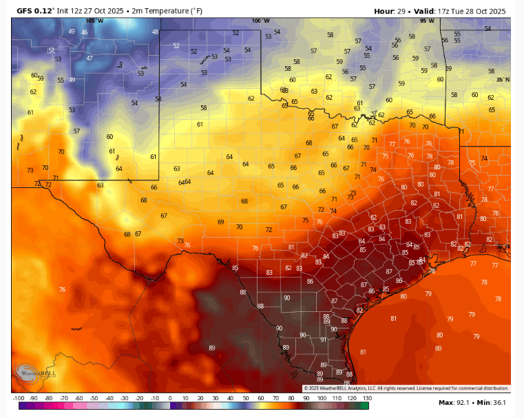
A strong upper-level system of low atmospheric pressure will swing southward over the Great Plains and the Mississippi River Valley on Tuesday, ushering in a strong cold front across the Lone Star State. The front will move through areas along the Rio Grande, the Edwards Plateau and the Texas Hill Country late Tuesday morning. It will cross the Interstate 35 corridor around midday, and exit the Coastal Plains in the evening.
Tuesday morning temperatures will be muggy, near 70 degrees, before afternoon highs approach 90 in Austin, which is about 10 to 15 degrees above the late-October average low of 57 and average high of 79.
The front will be mostly dry, with only a slim 20% chance of rain, especially east of Interstate 35. Partly cloudy skies and blustery north winds will accompany the front, along with a steady drop in temperatures during the late afternoon and evening.
Cooler air will rush in behind the strong cold front Tuesday night, bringing a dramatic shift to our Central Texas weather. By daybreak Wednesday, temperatures are expected to drop into the 40s and 50s, with afternoon highs only reaching the mid- to upper 60s.
Thursday and Friday will be sunny and, with clear skies each night allowing a good amount of radiational cooling, we’re expecting a big swing in temperatures from day to night. Both mornings will see widespread temperatures in the 40s around daybreak and afternoon highs in the 70s. This will be some of the coldest air we’ve felt since early April.
However, the front won’t just bring cooler air. Gusty north winds will continue through Wednesday, and with extremely low humidity levels, conditions will become favorable for wildfire spread. The National Weather Service has issued a fire weather watch, meaning critical fire weather conditions are expected. Outdoor burning is strongly discouraged, and everyone is urged to use caution with any activities that could spark a fire.