
CORPUS CHRISTI, Tx — Hey there Coastal Bend!
WHAT YOU NEED TO KNOW
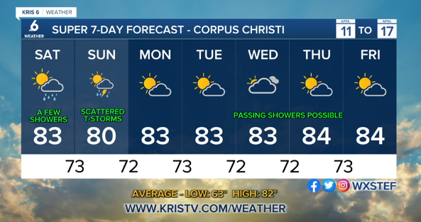
A few showers possible overnight and for SaturdayThunderstorm chances increase into SundayIf the storms get going a few could be strong to severe (we’re in a level 1 out of 5 risk currently)Stable daytime highs in the low 80s with high humidity
As we get ready to head into the weekend we’re seeing plentiful moisture that has moved into our region from the gulf. Thanks to this we’ve been seeing some isolated and scattered showers around the past couple of days, and it’s expected to continue as we’re heading into the weekend! Overall the pattern looks pretty similar with most of the day coming in dry and a few “rain lottery” winners with the brief showers that develop. Going into Sunday we start to see another chance for some of these to become thunderstorms, with the SPC putting the entire region under a level 1 out of 5 (Marginal) threat of the storms growing to severe limits, so something to keep in mind if you’re making plans.
However, still keep in mind that the pattern will still be for isolated development. Meaning even though the chance slightly increases, most of us will likely still come in dry or only see some minimal rainfall totals around ~0.20″ or less.
Temperature wise we’re looking fairly stable through the seven day forecast with daytime highs in the low to mid 80s and overnight lows in the lower 70s. The humidity we saw come back the past few days is also expected to remain with us daily through the forecast. As we head deeper into April now, we can expect this trend to become a little more common with slowly rising daytime highs and humidity values on the rise.
CORPUS CHRISTI FORECAST
Tonight: Mostly Cloudy, Isolated Showers possible
Temperature: 70F
Winds: SE 10-20 mph
Tomorrow: AM Isolated Showers, Mostly Cloudy Skies
Temperature: 82F
Winds: SE 15-20 mph, G 20-30 mph
Saturday night: Mostly Cloudy, Isolated Showers and T-Storms
Temperature: 71F
Winds: SE 10-20 mph
We hope you have a great weekend Coastal Bend!