
Plenty of atmospheric moisture streaming in from the south over the past few days has led to scattered showers and storms across Central and South Texas. However, rainfall totals have been quite light.
If you haven’t seen much rain yet, you’ll have another chance this weekend. Storm coverage will rise, and a few storms may also bring isolated large hail and flooding. The highest risk for severe weather will stay north and west of San Antonio, but isolated severe thunderstorms are still possible locally, especially by Sunday. Here’s a timeline of what you can expect.
Saturday morning: Relatively quiet weather is expected in San Antonio Saturday morning, but a few scattered showers (30% chance) are still possible. Temperatures will start in the upper 60s, but rise into the lower 70s by 10-11 a.m.
Saturday afternoon: San Antonio’s best chances of rain Saturday will occur between noon. and 6 p.m. However, storms will still be scattered, meaning that not everyone will see significant rainfall. This activity also will move quickly, so rain likely won’t last for more than 30 minutes at a time. Bring an umbrella along, but don’t cancel any outdoor plans, as large parts of the day will remain dry.
Saturday evening: Rain chances will decrease, leading to mostly dry weather in South Texas through Saturday night. Temperatures will hover in the 70s with gusty southeast winds at 15-20 mph.
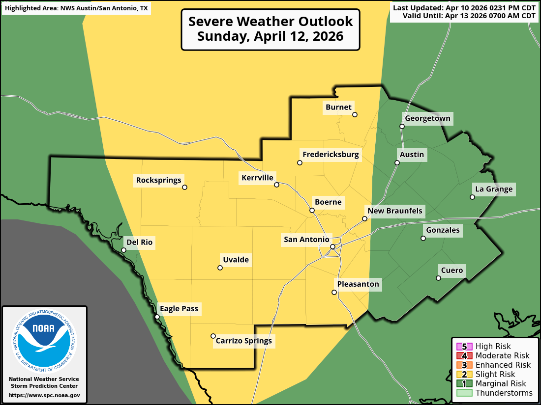
Sunday: The chance of strong to severe storms will rise on Sunday. First, a line of strong to severe thunderstorms is expected to push through parts of the Hill Country during the early morning, likely between 3 and 9 a.m. Most of this activity will stay northwest of San Antonio, but scattered showers and storms will stay possible through the morning.
Between 2 and 7 p.m. Sunday, South Texas will have its best chance of strong to severe thunderstorms, as overall rain chances will rise to around 60-70%.
The storms that do form could be quite strong, and the National Weather Service’s Storm Prediction Center has placed the region under a level 2 of 5 risk of severe weather. That means that a few storms will likely to produce large hail and damaging winds. The severe weather risk will be slightly higher to the north and west in places like San Angelo, Abilene and the Dallas-Fort Worth metroplex.
The areas that see the strongest storms also face an isolated flood threat. The National Weather Service has also placed the region under a Level 2 of 4 risk of excessive rainfall on Sunday.
Rain chances will decrease significantly by the start of next week. However, with atmospheric moisture levels staying high, an isolated shower or storm can’t be ruled out. Overall rain chances from Monday through Wednesday will be about 20% each day.
Temperatures will be on the warm side throughout the week. Expect temps to hit 83 degrees on Monday, before likely rising into the mid- to upper 80s by the end of the week. Mornings will be very mild, with temps falling to around 70 degrees next week. Expect especially humid weather during the week, too, especially on Monday and Tuesday.