
WATCH LIVE RADAR IN VIDEO ABOVEFORECAST HIGHLIGHTS
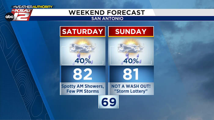
This weekend will not be a wash out. Rather, you should think of our rain chances as a “storm lottery.” Your chances stand at 40% both Saturday and Sunday. Here’s the latest…
SATURDAY NIGHT: Highest storm chance west of San Antonio
SUNDAY MORNING: Line of storms (weaker) may make it to San Antonio (40%)
SUNDAY AFTERNOON: A few storms (40%), otherwise warm. 80s
ANY HAIL? It’s possible Sunday, so we’ll be watching radar closely.
FORECASTWeekend (Copyright 2026 by KSAT – All rights reserved.)
SATURDAY
We’re starting the day with some spotty showers. As we get into the afternoon, lightning becomes possible. Overall rain coverage will be about 30-40%. Otherwise, warm and in the low-80s.
SATURDAY NIGHT
Saturday night’s futurecast (Copyright 2026 by KSAT – All rights reserved.)
Then, we’ll turn our attention to the west. Storms will develop in West Texas late Saturday. These will move east overnight. For those near Del Rio, Rocksprings, and the Hill Country this line could be strong or severe with hail and gusty winds possible overnight.
SUNDAY
Sunday’s forecast (Copyright 2026 by KSAT – All rights reserved.)
By sunrise Sunday, the storms will be much weaker as they approach San Antonio. In fact, they may fall apart completely. That being said, we’ll still carry a 40% chance for storms throughout the day Sunday. Otherwise, warm, and in the 80s.
RAINFALL
Higher totals will be west of San Antonio. For the most of us, we’ll likely see less than 0.25″.
Highest rainfall totals expected north and west of San Antonio. (Copyright 2026 by KSAT – All rights reserved.)
NEXT WEEK
Less active and warmer. By the start of Fiesta, it’ll be in the upper 80s.
The latest 7 day forecast from Your Weather Authority (Copyright 2026 by KSAT – All rights reserved.)Daily Forecast
KSAT meteorologists keep you on top of the ever-changing South Texas weather.
QUICK WEATHER LINKS
Copyright 2026 by KSAT – All rights reserved.