

AUSTIN, Texas — You may have heard the rumor: La Niña is coming to an end and El Niño is taking over and this global phenomenon has a surprisingly huge impact on our local weather here in Central Texas.
In fact, La Niña is largely to blame for our hot and dry weather the past few years. Starting in 2020, we have had nearly a constant streak of La Niña or ENSO-Neutral conditions, with the exception of an El Niño in 2023 and 2024. In that time, Central Texas has had worsening drought conditions and some of our hottest years on record.
But that could be changing soon. We are now in a neutral pattern borderlining on an El Niño. This is huge news since we need the hot and dry weather of March to finally lead to some April showers and cooler temperatures. And the news may get even better with what could be described as a “Super El Niño” possible later this year.
Before we break down what the “super” version is, let’s break down the actual meaning of El Niño and La Niña.
ENSO (El Niño Southern Oscillation) is the changing of temperature anomalies in the Central and Eastern Pacific tropical temperatures.
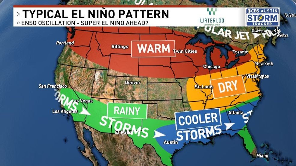
La Niña, which is what we’ve been stuck with for the majority of the past 5-6 years, is when that area of water is slightly cooler than average. This provides a rainy and cool winter for the Pacific Northwest, but we are usually stuck behind a ridge of high pressure, which usually keeps us hot and dry for prolonged periods of time – where have we heard that before??
El Niño usually does the exact opposite. Instead of a hot and dry winter and spring, it might be cooler and rainier. The tropical jet that provides the Pacific northwest with rain chances during La Niña instead shifts farther south down into our neck of the woods for much more frequent rain chances, which in turn will keep our temperatures down.
ALSO | City of Austin needs almost $84M to repair aging bridges, according to new memo
You may have heard the rumor: La Niña is coming to an end and El Niño is taking over and this global phenomenon has a surprisingly huge impact on our local weather here in Central Texas. (Graphic: CBS Austin)
Could this mean our drought’s days are numbered? It’s possible.
2015 was one of the strongest El Niños on record, and it was our second rainiest year on record. Just southeast of Austin that year, Onion Creek flooded on Halloween, killing three people. 1919 was Austin’s rainiest year on record, which was also another very strong El Niño – as was 1900, 2004, and 1991. These were some of the wettest years on record for Austin.
However, 2023 through 2024 was a very strong El Niño and we were still below average in rainfall. 2007 was one of the strongest La Niñas on record, yet it was an incredibly rainy year, the 11th rainiest year.
El Niño years tend to lead to rainier years for Texas, but it isn’t an absolute guarantee. Strong areas of high pressure can develop anytime of the year, leading to less rain chances and higher temperatures.
We’ve gotten new forecasts for this upcoming hurricane season, with many agencies forecasting below average activity. Strong El Niños are also known for producing quieter hurricane seasons by producing widespread wind shear. This keeps the Atlantic quiet, especially any activity in the gulf. Anything that does develop typically gets pushed out into the open waters of the Atlantic.
A “Super El Niño” is just a much stronger El Niño; anything warmer than 2C in the Pacific waters. A powerful El Niño can produce global issues with some places getting significant floods while others have worsening drought conditions. Australia, Southeast Asia, and Africa usually see dry and hot weather in the midst of El Niños. In Texas, however, this could mean more cooler temperatures and rainy weather throughout this year, and boy, we sure do need it.