
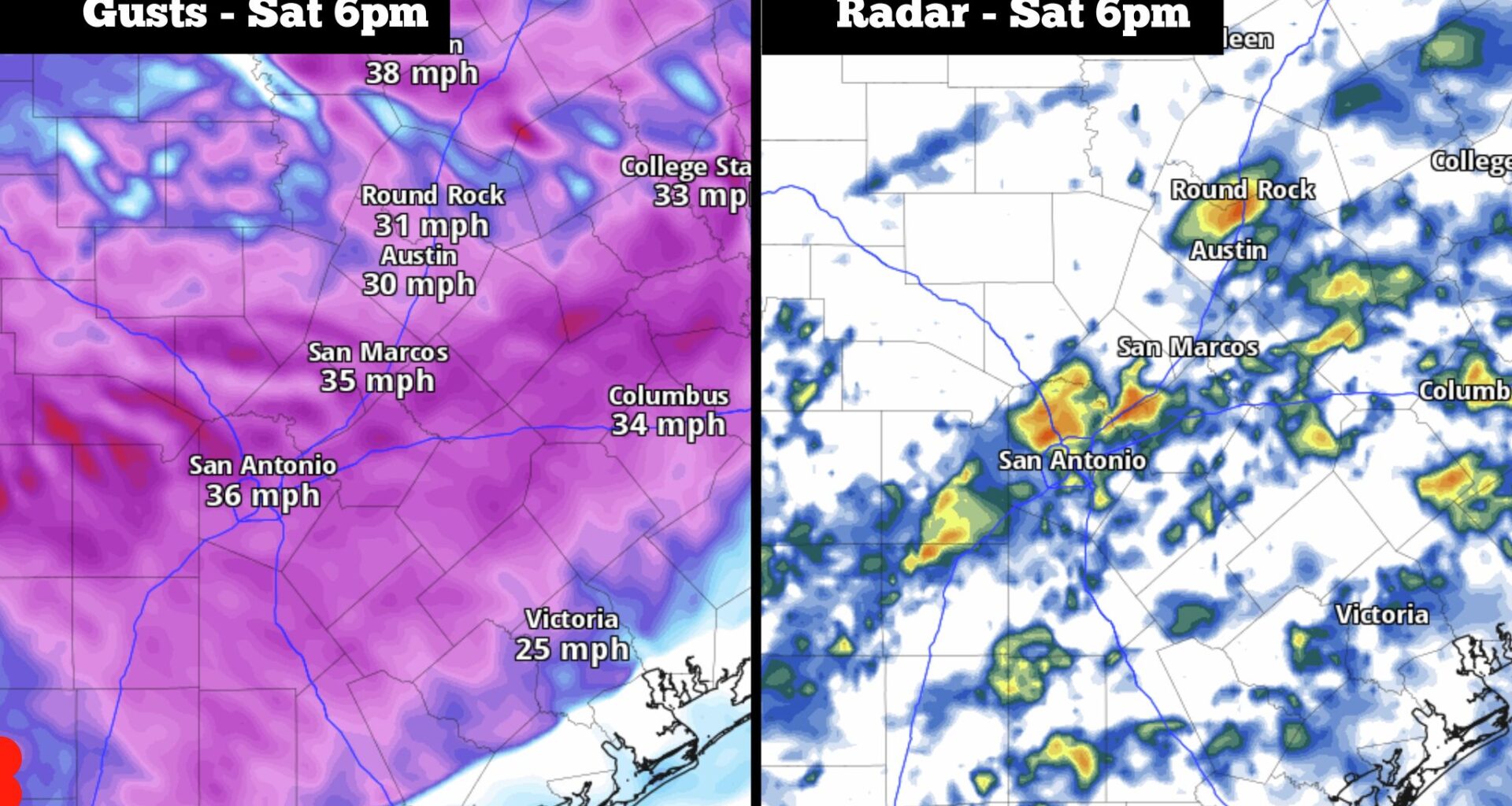
Shown are potential wind gusts and the future weather radar for South-Central Texas at 6 p.m Saturday. Gusts would reach 35 mph or stronger as scattered showers and storms move over the region.
Pivotal Weather
After a record warm February and March across South Texas, April has followed suit with continued abnormally warm weather. So far this month, San Antonio’s average temperature has been nearly six degrees above average, and highs have reached at least 80 degrees for the past 10 consecutive days.

That’s all about to change, though, as a strong cold front will sweep through South Texas Saturday morning. Not only will it bring a drastic temperature shift, but the front will also result in strong wind speeds and high rain chances. If you’re attending outdoor Fiesta events Saturday evening, consider bringing a rain jacket and an umbrella.
Article continues below this ad
Saturday’s forecast
Early Saturday, the weather will actually feel very similar to what’s we’ve experienced in the past several days — temperatures will sit in the lower 70s with cloudy skies overhead through 9 a.m.
Shown are projected Texas temperatures as of 10 a.m. Saturday, as a cold front pushes through San Antonio.
WeatherBell
The cold front is expected to quickly move into the San Antonio metro area by around 10 a.m. At that point, winds will immediately shift direction from the north, sending colder air into the region. Temperatures will likely sit in the 60s through much of the afternoon, eventually falling into the upper 50s after 5 to 6 p.m.
Article continues below this ad
The cooler temps, combined with high winds, will make the weather feel almost winter-like. Expect sustained north winds at 15 to 20 mph throughout much of the day, with some gusts likely exceeding 30 mph.
Rain chances: Initially, after the front moves through, rain chances will be relatively low, with only a 20-30% chance of scattered showers and storms through 3 p.m. However, chances will increase by the second half of the day. Between 6 p.m. and midnight, overall rain chances will reach 60%.
Thankfully, severe thunderstorms are unlikely, meaning that large hail and damaging winds are not expected to occur. However, off-and-on light to moderate rainfall is expected late into Saturday night.
Article continues below this ad
Sunday and Monday
Sunday morning will be chilly, as temperatures in the lower to mid-50s will be accompanied by northerly winds blowing at 15 to 20 mph. A few rain showers will be possible early on, but drier weather is likely to prevail by the middle of the day. Rain chances after 9 a.m. will be only around 20%.
Temperatures will rise steadily throughout the day, reaching the mid-60s by noon, before topping out in the lower 70s — which would be about 10 degrees below average for mid- to late April. Skies are expected to be mostly cloudy, but a few peeks at sunshine through the clouds will be possible during the afternoon.
Rain chances will return again on Monday, as a weak system of low atmospheric pressure brings scattered showers into South Texas. The best chance of rain will occur during the morning and afternoon, but a few showers could linger into the evening, possibly affecting those attending the Texas Cavaliers River Parade in downtown San Antonio.
Article continues below this ad
With showers and overcast skies over the region, Monday temperatures will stay especially cool, with afternoon temps likely sitting in the mid- to upper 60s.
Warming back up
A few scattered rain showers might linger into Tuesday, with about a 30% chance of more rainfall for San Antonio. Temperatures will start to rebound closer to normal levels, reaching the mid-70s by the late afternoon.
Article continues below this ad
By Wednesday and Thursday, temperatures will continue their upward trend, reaching the mid-80s each day. A few scattered thunderstorms are also possible by the end of the week.