
Storms are expected to move into Houston and Southeast Texas late Saturday and overnight, bringing a round of heavy rainfall before an associated cold front produces a sharp drop in temperatures by Sunday. While severe weather isn’t expected, a few storms may produce brief downpours and gusty winds, with localized flooding possible in spots.
Morning: Saturday starts warm and muggy with mostly cloudy skies. A few showers or thunderstorms might develop well north of Houston, but most of the metro area will stay dry through late morning as temperatures climb through the 70s.
Afternoon: Most of Southeast Texas remains rain-free through the afternoon despite the approaching front. Highs reach the mid-80s, with increasing clouds and humidity setting the stage for storms later in the day.
Evening: Rain chances begin to edge up between 6 and 8 p.m. as scattered showers approach. Storms will be limited at first, but the weather will continue to be more unsettled. The High-Resolution Rapid Refresh forecast model shows showers developing north of Houston in the Brazos Valley and in East Texas around this time.
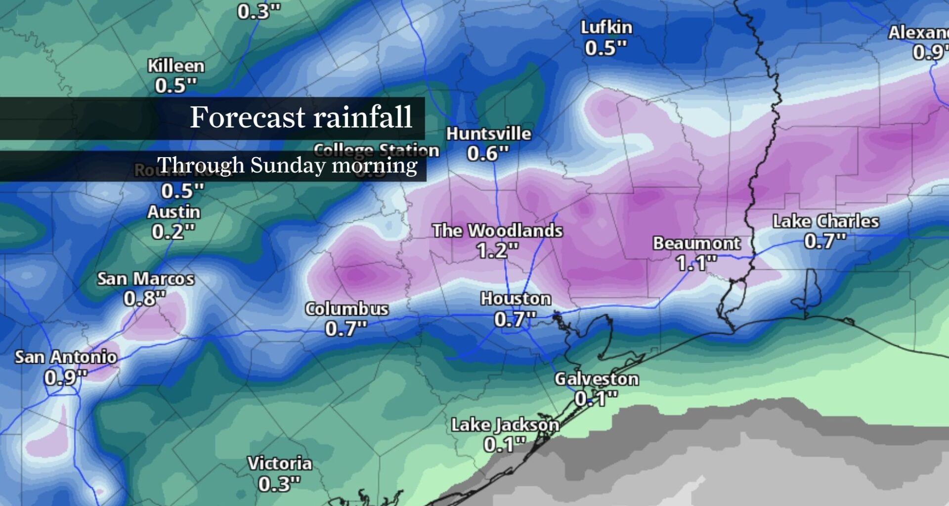
Late night into early Sunday: The main round of storms arrives overnight, with a narrow line moving across the region between about 10 p.m. and 4 a.m. This will be the period with the highest likelihood of rain. A few storms might produce gusty winds and brief heavy downpours. Localized flooding is the primary concern overnight, especially in low-lying spots or paved areas with poor drainage. Most locations will pick up between a half-inch and 1.5 inches of rain, with higher totals possible north of Interstate 10.
The High-Resolution Rapid Refresh forecast model again shows a heavy band of storms stretched across Southeast Texas, affecting areas from the upper Rio Grande Valley, San Antonio, Houston and Beaumont around this time.
By Sunday morning, the front will be east of the area, and weather will begin to improve. A few lingering showers might persist early, especially closer to the coast, but skies should gradually clear through the day. Highs will only reach the upper 60s to low 70s.
Breezy weather is expected behind the front, particularly along the coast, before winds ease Sunday night. Overnight lows will drop into the mid-50s to low 60s.
The cooler pattern continues into Monday with peak daytime temperatures again in the upper 60s to low 70s, but this break from unseasonable heat will be short-lived. Southerly winds return late Monday, allowing temperatures and humidity to build again through midweek, along with periodic rain chances.