
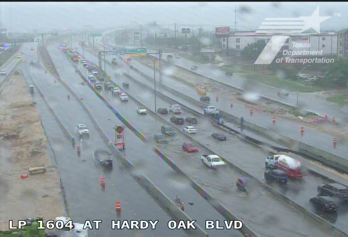
Flooding reported along Loop 1604, TxDOT cameras show.
Courtesy of TxDOT
Did you remember your umbrella? Thunderstorms will continue to plague San Antonio on Monday, April 20, according to the National Weather Service (NWS). Forecasters say showers are also likely to develop over South-Central Texas today.

“Some locally heavy pockets of rain are possible but for the most part, a steady soaking rain is expected,” the agency said in a post on X.
Article continues below this ad
Just before 2 p.m., NWS issued a Flash Flood Warning for the San Antonio area. An hour later, the flood warning was extended to 6 p.m. It was then extended once again to 9 p.m.
“This is a dangerous and life-threatening situation. Do not attempt to travel unless you are fleeing an area subject to flooding or under an evacuation order,” an emergency alert sent to cell phones read.
Radar showed heavy rain moving into the Hill Country around 8:45 a.m. The system was heading over the Interstate 35 corridor, the NWS said on social media. Minimal lightning has been reported, unlike the previous few days. However, temperatures are in the 50s, and wind gusts could be as high as 20 mph, making it feel more frigid.
12PM Update: Continued beneficial rains. Not overly heavy, but a steady rain that can soak into soils more efficiently. pic.twitter.com/2A8aOqpdpp
— NWS Austin/San Antonio (@NWSSanAntonio) April 20, 2026
The following towns are at a level one out of four risk for locally heavy rainfall, according to the NWS: San Antonio, Boerne, Pleasonton, Uvalde, New Braunfels, Gonzales, and Cuero. This means they are expected to see rain amounts from a quarter to 1.50 inches, with isolated areas seeing three inches. There’s a level one risk for flooding in the region.
Article continues below this ad
The gloomy conditions come as the city’s annual Fiesta celebration is underway. At least one event, the Air Force Day at the Alamo, has been canceled with no rescheduled date as a result.
The National Weather Service says isolated thunderstorms and rain showers are likely throughout Monday, April 20, 2026, in San Antonio, Texas.
Courtesy of the National Weather Service
Residents are being encouraged to review their safety plans, stay aware of changing conditions if spending time outdoors, and enable multiple ways to receive weather warnings. The precipitation chance sinks to 70 percent after sunset. Storms may return between 1 a.m. and 4 a.m., per the NWS.
Article continues below this ad
Those who are missing their short sleeves won’t have to wait long. Tuesday, April 21, will kick off a trend of warmer days, according to the NWS. Don’t forget to wear shoes you aren’t afraid to ruin, though, because there’s still an 80 percent chance of rain.
Is the Texas Cavaliers River Parade still happening?
Rain or shine, organizers said the 81st Texas Cavaliers River Parade would take place Monday, April 20, 2026. However just before 5:30 p.m., organizers shared an update on the parade.
The Texas Cavaliers shared the following statement:
“It is with deep disappointment that the Texas Cavaliers announce the cancellation of the 81st Annual River Parade. Out of an abundance of caution, the City of San Antonio has issued a cancellation order, and we must respect this decision,” the Texas Cavaliers wrote on Facebook. “The safety and well-being of our participants, guests, volunteers, and the broader community remains our highest priority.”
Article continues below this ad
Road closures in San Antonio area
The Bexar County Sheriff’s Office shared road closures due to flooding. Here are the following streets to avoid: Menger Drive in both directions and Fredericksburg Road in both directions.
Poss Road is also closed due to flooding, according to the City of Leon Valley.
The Texas Department of Transportation also stated the roadway on Bracken at FM 2252 is closed until water levels recede and the roadway is safe for travel.
North East Independent School District says to expect bus delays
The Northeast Independent School District (NEISD) says that parents, guardians, and students should expect bus delays this afternoon. Due to the heavy rainfall, drivers will travel their routes with extra caution to ensure student safety, a message from the district read.
Article continues below this ad
“With some areas of the District experiencing rising water, some of our drivers will be rerouting in instances where there are low water crossings,” NEISD said in a post. “As the afternoon progresses, we will likely be a little later than usual at some of the Middle School and High School campuses, but our intention is to ensure every bus reaches every campus and every stop along its route.”