
LUBBOCK, Texas (KCBD) – Some mixed news about our weather heading into the weekend. After a brief break from the wind on Friday, hot, dry, and windy weather returns this weekend. Critical wildfire conditions are expected, especially Sunday, with elevated fire danger continuing through at least Tuesday.
Quiet Night
Weather tonight into early Friday will be quiet and mild. Winds will decrease through the evening as a weather system moves off to the northeast. The afternoon and evening clouds will gradually thin and move east with generally a clear sky by sunrise.
 Lows from near average in the northwest to nearly 10 degrees above southeast.(KCBD First Alert)
Though it will get chilly over the northwestern viewing area, lows there will be about average for late April. At the opposite corner of our area, lows will come in about ten degrees above average.
Pleasant Day
Friday offers some relief from the recent windy periods. Winds will be noticeably lighter. Sunshine will be more plentiful.
 Temperatures Friday will peak around eight degrees above average for the date.(KCBD First Alert)
While in generally it won’t be as warm as Thursday, I expect highs around eight or nine degrees above average, so still warm. Overall, pleasant outdoor weather through the evening.
Heating Up
Saturday brings back the heat and a bit of a breeze. Winds will increase in the afternoon to around 10 to 20 mph with gusts near 30 mph likely. Temperatures will climb back into the 80s and 90s.
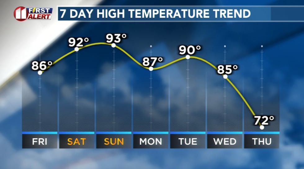 Very warm to hot afternoons through early next week.(KCBD First Alert)
Humidity will drop into the single digits to lower teens.
The combination of heat, low humidity, and wind, will create an elevated wildfire danger across the region. Saturday is a NO BURN DAY. Outdoor burning should be postponed.
Critical Wildfire Danger
Sunday will be the most critical day when it comes to the wildfire danger for the area.
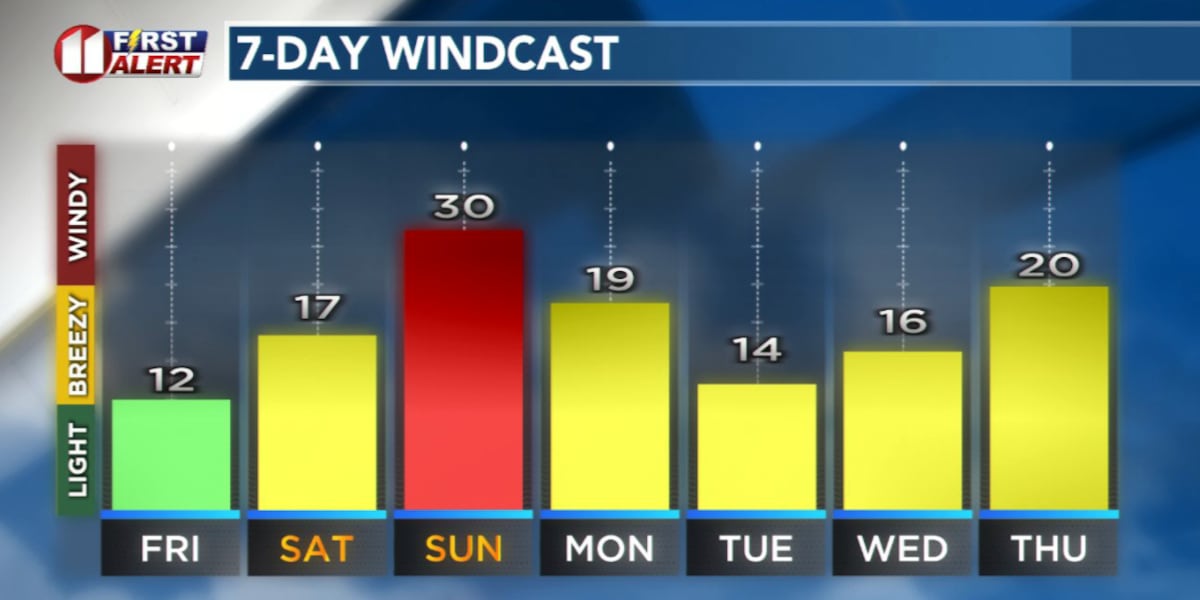
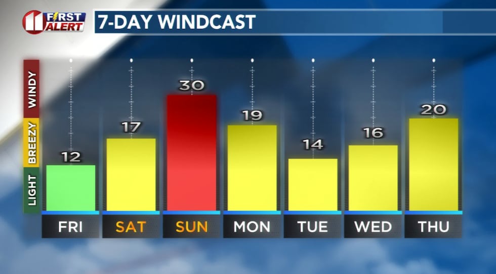 Forecast peak sustained winds are shown in this graph. Peak gusts will exceed the values shown here.(KCBD First Alert)
We expect the wind to ramp up during the morning and then a very windy afternoon and early evening. Temperatures will edge up, generally peaking in the 90s. Humidity will plummet to single digits. These conditions will produce critical wildfire weather. Sunday is also a NO BURN DAY.
Additionally, blowing dust is possible Sunday afternoon into early evening, which could reduce visibility on roadways, creating hazardous driving conditions.
Not a Drop
Friday through Monday will be bone dry with no rain in sight. This lack of moisture, combined with the conditions previously mentioned, creates a near perfect recipe for rapid fire spread. Any fire that starts could spread quickly and become difficult to control.
 Not a drop of rain is expected through at least early next week.(KCBD First Alert)
Secure any outdoor items which could blow away or ignite. Stay alert to local weather conditions. Keep your phone charged.
Possible Change
A cold front may bring some relief mid- to late next week. That includes, possibly, a slight chance of rain and several cooler days.
On This Date
On this date in 1980, an intense upper level low resulted in several strong storms from the
northern TX Panhandle south to the Permian Basin. On the South Plains, nearly four inches of rain fell in less than one hour in Tahoka causing flash flooding. Some cars were stranded under some of the HWY 87 overpasses requiring high-water rescues. Water was reported in some residences.
(Source: National Weather Service, Lubbock)
Copyright 2026 KCBD. All rights reserved.