
Above-normal temperatures are favored through the end of April across central and southern Texas, according to NOAA’s Climate Prediction Center. While the trend leans warmer, we don’t yet have a strong signal that extreme or sustained early-summer heat will take hold over the next couple of weeks.
NOAA’s Climate Prediction Center / Pivotal Weather
Houston is getting a taste of summer, but it’s not the real thing just yet.
After a mostly quiet and warm Thursday, the forecast into Friday and the weekend looks more like a summer preview than a full seasonal shift.
THIS WEEKEND ONLY: Hurricane supplies are tax-free in Texas this weekend only. Here’s what to buy now.
Article continues below this ad
Temperatures are trending upward, humidity is creeping in and rain chances are becoming more scattered — a combination that might feel familiar in a few more weeks, but it isn’t fully locked in yet.
Temperatures climb toward 90
Peak daytime temperatures will continue to rise through the end of the week, approaching the 90-degree mark by Saturday. That’s a noticeable shift toward early-summer warmth, especially for April, and it will come with a gradual increase in humidity.
Even so, this doesn’t appear to be a sustained heat wave. The pattern still shows some variability, suggesting Houston is in more of a transition phase rather than a full seasonal change.
Article continues below this ad
Spotty storms continue, with a low-end risk Friday
Rain chances drop off after Thursday, but they won’t disappear entirely. Each day through the weekend carries at least a small chance for a stray afternoon or early evening storm, driven mainly by daytime heating.
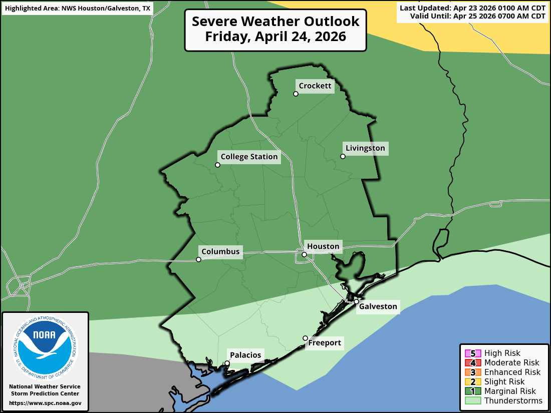
The severe weather outlook for Friday in Southeast Texas includes a risk for isolated thunderstorms capable of producing damaging wind and possibly hail, according to NOAA’s Storm Prediction Center.
NOAA’s Storm Prediction Center
Friday stands out a bit more. The National Weather Service’s Storm Prediction Center has placed areas generally along and north of Interstate 10 under a low-end level 1 of 5 risk for severe weather. Isolated to scattered storms are expected to develop during the afternoon and could persist into the evening.
SEVERE LEVELS EXPLAINED: How to understand storm risk levels in Houston weather forecasts.
Article continues below this ad
The threat of severe weather is conditional — meaning many storms could struggle to organize — but any storm that can sustain an updraft could briefly become strong. The main concerns would be damaging wind gusts and hail, especially in stronger storm cells.
Outside of that, storm activity should remain limited. Most neighborhoods will stay dry, while a few could see short-lived downpours, lightning and gusty winds.
Long-range outlook keeps Houston warmer
Looking ahead, broader weather patterns suggest Houston could remain near normal or slightly warmer than normal into early May, even as below-average temperatures settle across much of the central and eastern United States.
Article continues below this ad
Forecast confidence decreases in the eight-day to 14-day range, particularly when it comes to rainfall. So far, we don’t have a strong signal for a prolonged stretch of extreme heat or a completely dry pattern.
For now, the takeaway is straightforward: Summer is knocking on the door, but it hasn’t fully moved in. Expect warm, increasingly humid days with just enough storm chances to remind you that spring isn’t quite done.