
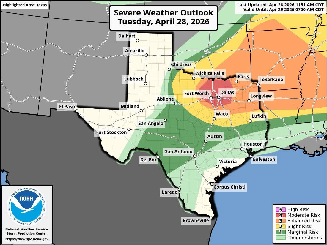
The Storm Prediction Center’s severe weather outlook for Tuesday shows a Level 4 of 5 risk of severe storms for parts of North-Central Texas, with a Level 3 risk extending into Northeast Texas.
Pivotal Weather
An active weather pattern is setting up across Texas, as a cold front moving into North Texas interacts with high levels of atmospheric moisture. Along the front, scattered strong to severe storms are expected to develop Tuesday afternoon, with large hail, damaging winds and tornadoes expected to be potential threats.
As the front continues to the south on Wednesday, the severe weather shift will shift to portions of Central and South Texas, including Austin and San Antonio. Here’s an overview of what to expect in Texas over the next 48 hours.
Tuesday severe weather
Thunderstorms along the Red River were soaking far North Texas Tuesday morning and, by the middle of the day, more storms are expected to develop. These storms will move east-southeast, likely affecting parts of the Dallas-Fort Worth metroplex as well as East Texas by the late afternoon and evening.
Article continues below this ad
The National Weather Service’s Storm Prediction Center has upgraded parts of North Texas to a rare level 4 of 5 risk for severe weather, which includes the Dallas-Fort Worth metroplex and areas northward to Sherman and Denison. A level 3 risk of severe storms extends eastward to include Tyler, Longview, and Texarkana. The highest chances for storms in the metroplex are expected between 4 and 8 p.m.
The potential future radar model for 6 p.m. Tuesday shows a cluster of strong to severe storms rolling through the Dallas-Fort Worth metroplex.
Pivotal Weather
The atmosphere across this region is expected to grow extremely unstable by the afternoon. Because of that, the weather agency notes that the strongest supercells could produce “very large to giant hail”, measuring 2 to 4 inches in diameter. A few isolated tornadoes could arise in this region, especially during the early evening.
As storms continue south after sunset, they are expected to weaken. Still, a level 2 of 5 risk for severe weather has been assigned to an area stretching from Waco eastward to Lufkin, as a few storms might produce large hail between 9 p.m. and 2 a.m.
Article continues below this ad
An even lower severe weather risk — level 1 of 5 — is in place Tuesday for South and Central Texas, including Austin, San Antonio, and the Hill Country. Here, an isolated severe storm could develop during the late afternoon or evening, but overall coverage will be very low. San Antonio’s storm chances will be under 20% through Tuesday evening.
Wednesday storms shift south
As the cold front shifts to the south on Wednesday, so will the higher storm chances. Weather models suggest that a cluster of storms may develop across the Texas Hill Country Wednesday morning, moving east to the Interstate 35 corridor by the middle of the day.
From left, the potential future radar model for 11 a.m. Wednesday shows a cluster of thunderstorms moving toward the Interstate 35 corridor. A low-end level 1 of 5 risk of severe weather is in place.
Pivotal Weather/Storm Prediction Center
Currently, a low-end level 1 of 5 risk for severe weather is in place for the Hill Country, eastward to San Antonio, Austin, and even the Houston area. While the overall severe weather risk is lower than what North Texas is seeing on Tuesday, a few storms could still produce large hail and damaging winds.
Article continues below this ad
Parts of our region could be upgraded to a higher risk of severe storms as weather models become more precise with timing and exact positioning.
Not everyone will see rain. In San Antonio, overall storm chances are about 30-40%, with the highest chances occurring between 11 a.m. and 4 p.m. Rain chances will be a bit higher to the north, with a 50% chance of storms expected in Austin.
The cold front also will bring lower temperatures to San Antonio. After highs reach the 90s on Tuesday, afternoon temperatures will likely top out in the low to mid-80s on Wednesday. An even stronger cold front is expected to move through by Friday, bringing more chances of thunderstorms.