
As April wraps up and May begins, Texas is bracing for another significant storm system that will bring widespread rain and a sharp drop in temperatures heading into the weekend. The contrast across the state will be striking, with a temperature difference of up to 45 degrees from the Panhandle to the Rio Grande Valley.
This comes on the heels of an already active week of weather, as the first cold front sparked multiple rounds of severe storms across North and Central Texas. Five tornadoes were reported, including a powerful EF3 in Mineral Wells, just west of Fort Worth, with peak winds reaching 145 mph.
The second storm system will be broken up into several pieces. First, a broad upper-level trough of low atmospheric pressure and an associated cold front are stretching from the northern Great Plains through the upper Midwest and into the Northeast. Out west, another system is pushing east from California, with several atmospheric disturbances moving into the Lone Star State.
This setup will bring moderate to heavy rainfall to parts of Texas on Thursday and Friday, followed by a surge of colder air as high atmospheric pressure builds in for the weekend. Temperatures will run about 10 to 15 degrees below the climate-average, with some locations in the Texas Panhandle dropping into the 30s, or near freezing.
In fact, the weather could be cold enough for areas of frost to develop Saturday morning.
Just to our west in New Mexico, wintry weather is making a return. Snow is expected in the Sangre de Cristo Mountains, as well as the Johnson and Bartlett Mesas and around Raton Pass — less than two hours from the Texas border. Snow totals could range from 2 to 8 inches between 7,500 and 9,500 feet, with 8 to 14 inches possible above 9,500 feet.
Notably, this is all happening in the first few days of May, highlighting just how cool and unseasonable this air mass is for this time of year.
As high pressure settles in Saturday and Sunday, temperatures in Central Texas will rebound, peaking in the 60s and 70s.
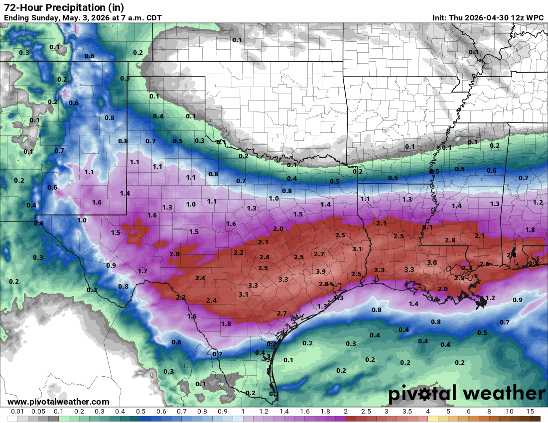
Rainfall over the next few days will be quite heavy, with the highest totals expected in a swath from near Del Rio through the Hill Country and Central Texas, extending into the Piney Woods of East Texas. Rainfall amounts will range from 2 to 3 inches, with isolated higher totals possible.