
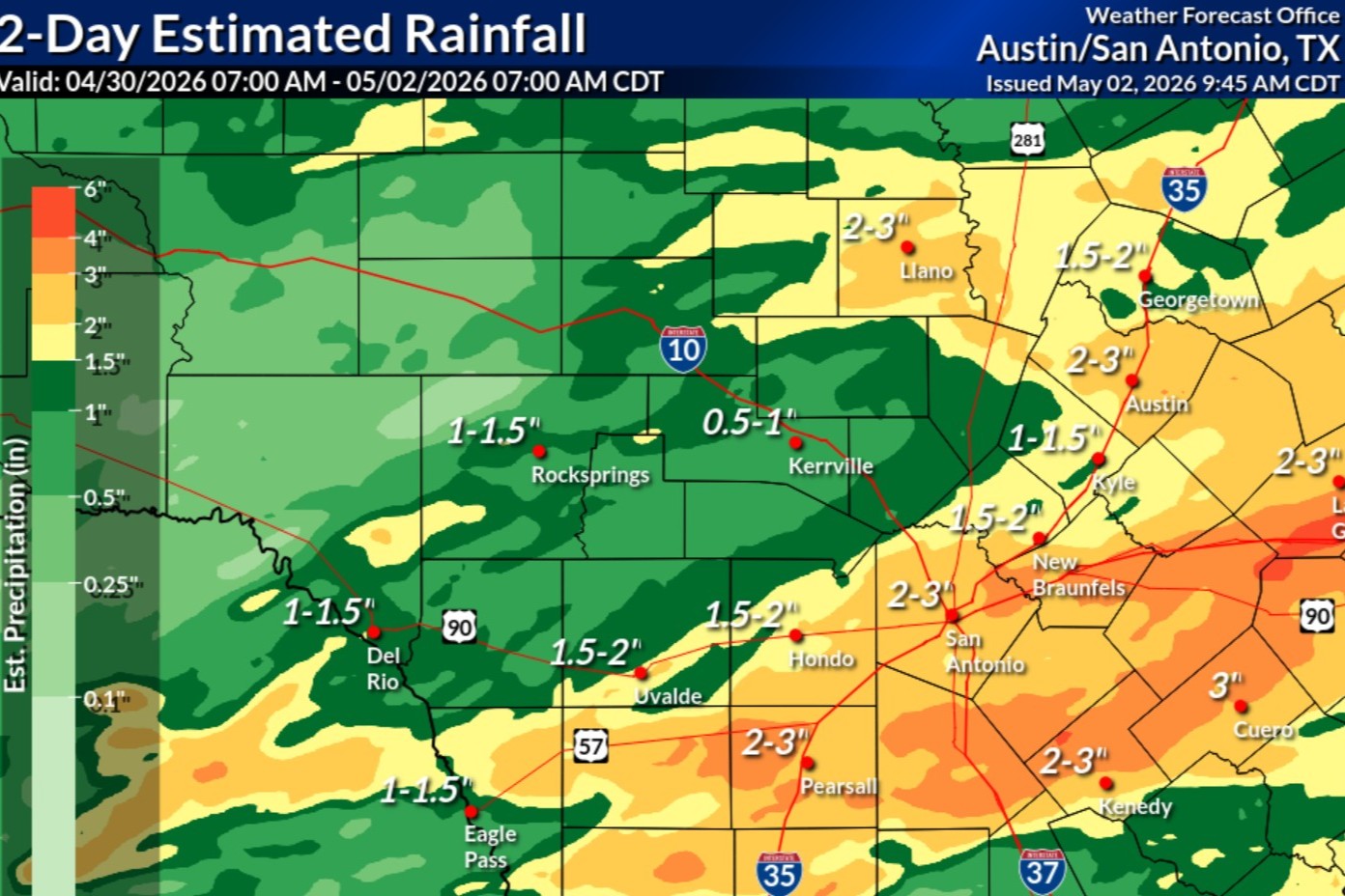
Shown above are rainfall totals recorded from 7 a.m. Thursday to 7 a.m. Saturday, according to the National Weather Service. The Austin area saw between 2 and 3 inches of rainfall over the 48-hour period.
National Weather Service
What a way to kick off what is typically Austin’s wettest month of the year. After a series of showers and storms Friday, Central Texas welcomed the return of sunshine Saturday and will see more blue skies Sunday.

Friday was the first day of May, and some spots across Central Texas picked up an impressive 1.5 to 2.5 inches of rain. That was enough to give May 2026 one of the top five wettest starts on record.
Article continues below this ad
To put that in perspective, that single day produced 1.58 inches at Camp Mabry, which is about 31% of Austin’s normal rainfall for the entire month. On average, May generates about 5.04 inches of rain there, so we’re already off to a soaking start.
May is, on average, Austin’s wettest month of the year with a normal monthly rainfall total of just over 5 inches. The second wettest month, on average, is October.
National Weather Service
And if history is any hint of what’s possible, some of Austin’s wettest Mays have produced truly remarkable rainfall totals, including:
17.59 inches in May 2015
12.75 inches in May 1929
12.57 inches in May 1914
Article continues below this ad
Could this be the beginning of another soggy May? Time will tell, but we’re certainly off to a wet start and the National Weather Service’s Climate Prediction Center is predicting a wetter May than normal.
The month of May looks to be settling into a wetter pattern than normal across Texas.
Climate Prediction Center
Sunday forecast
Austin on Sunday should continue to be sunny, as temperatures climb to near 80 degrees again. Warmer southerly winds at a light 5 mph will return in the afternoon. At night, skies turn partly cloudy but that will help keep temperatures above 60 degrees.
Article continues below this ad
“Sunday remains mostly sunny but trends slightly warmer, compared to (Saturday) afternoon as a southerly low-level flow returns with the surface
high pressure sliding towards the east,” the weather service said in a forecast bulletin Saturday.
Forecasters explained that the “southerly low-level flow” is bringing more atmospheric moisture into the Central Texas, thanks to a surface low pressure system off the Rockies over the central Plains.
“This would result in a steady warming trend across our region and an increase in humidity,” the weather service said.
After morning temperatures dipped into the 40s and 50s across Texas, they will warm up nicely on Sunday afternoon with highs in the middle and upper 70s.
Pivotal
May is a transition month
May in Austin traditionally has taken us from pleasant spring weather to the first taste of a hot, humid summer, all in just 31 days.
Article continues below this ad
Early in the month, temperatures are typically start out at 63 degrees in the morning and peak at 83 degrees in the afternoon. By the end of May, mornings, on average, stay warm in the 70s but get hotter in the afternoons, with temps as high as the 90s, signaling summer is right around the corner.
We also gain more daylight as the month goes on. Sunrise shifts earlier by about 20 minutes, from 6:47 a.m. in early May to 6:29 a.m. by late May, while sunset stretches later into the evening, moving from 8:08 p.m. to 8:27 p.m.
While we are leaning into a transition month, the first couple of days of May have been cooler than average, with morning lows in the 40s and 50s and then afternoon highs in the 70s.
Article continues below this ad
Our next storm system will bring a small chance for rain and thunderstorms by midweek.
Weather Prediction Center
As we head into the work week, temperatures will warm quickly, with highs reaching the 80s by Monday and nearing 90 on Tuesday.
After a sunny weekend, clouds will begin to return early next week, following a pattern of overnight cloud cover and afternoon sunshine. That trend continues until Wednesday, when clouds take over ahead of a dry line separating arid and humid air masses, and a cold front that will bring a small chance for thunderstorms during the afternoon.